Mountains & hills · Mid Wales
Hay Bluff
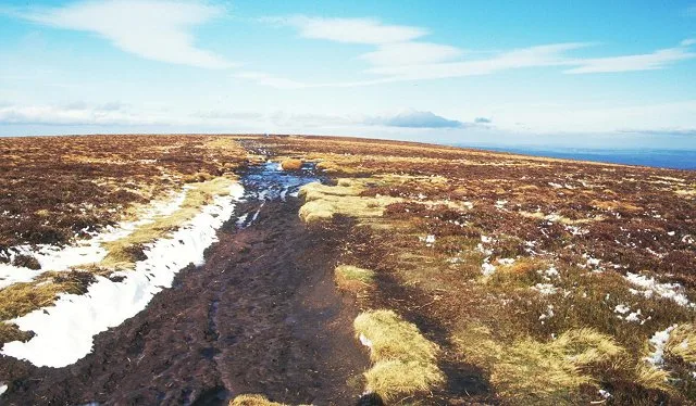
Hay Bluff — Named summit at 677 m.

Wikimedia Commons contributors — see linked file page for photographer and licence licence
Plan your visit
- Typical visit
- 3 h–8 h
- Best time of year
- Late spring – early autumn (May–Oct)
- Free entry
- Dog-friendly
About
Hay Bluff is a named summit in the United Kingdom. Wikidata describes it as: "Named summit at 677 m.". Coordinates: 52.0229°, -3.1027°.
Photo gallery
Protected designations
- Site of Special Scientific Interest: River Wye SSSI
Designations sourced from Natural England open data under OGL v3.
From the Wikipedia article
Hay Bluff (Welsh: Penybegwn) is a prominent hill at the northern tip of the Black Mountains, an extensive upland massif which straddles the border between south-east Wales and England. The mountain sits at the point where the main northeast-facing escarpment of the Black Mountains meets the northwest facing escarpment, the next peak to the west being Twmpa. The flat summit of Hay Bluff which is marked by a triangulation pillar at a height of 677 metres (2,221 ft) overlooks the middle Wye Valley and the book town of Hay-on-Wye. The hill is largely within the Welsh county of Powys though parts of its eastern flanks lie within the English county of Herefordshire. In 2024 a monolith similar to the one in Utah was found atop the hill. It is unknown who placed it there or for what purpose.
Excerpt from Wikipedia under CC BY-SA 4.0. See the source article linked in Sources below.
Background
Visiting
The Offa's Dyke national trail makes a steep ascent of the hill's northern slopes and then heads south eastwards along the broad ridge of the Black Mountain and the Hatterrall Ridge. A more gentle path to the summit follows the crest of the northwest-facing scarp, known as Ffynnon y Parc, from the road summit about 1 mile / 1.7 km to the southwest at Gospel Pass. There is also a clear, but unpaved path which passes along the edge of the escarpment to the east with good views over the countryside towards Hay-on-Wye. It leads to the trig point at the Black Hill (Herefordshire), and continues on to the south-east dropping down the stony knife-edge ridge towards Longtown. There is a small car…
Sourced from Wikipedia under CC BY-SA 4.0.
- Coordinates
- 52.0229, -3.1027
- District
- Powys
- Parish
- Llanigon
- Postcode
- HR3 5RJ
- Parliamentary constituency
- Brecon, Radnor and Cwm Tawe
Sources
- osm: n2323297665 (ODbL)
- wikipedia: Hay Bluff (CC BY-SA 4.0)
- commons: Hay Bluff. Black Mountains Hay-on-Wye - geograph.org.uk - 30553.jpg (CC BY-SA 4.0)
Other places nearby
Loading nearby places…
Nearby
 📷 4
📷 4Viewpoints · Mid Wales
Hay Bluff
Hay Bluff is a viewpoint in the United Kingdom.
 📷 5
📷 5Other places · Mid Wales
River Monnow
River Monnow in Wales Mid, United Kingdom.
 📷 3
📷 3Stone circles · Mid Wales
Pen-y-Beacon Stone Circle
Pen-y-Beacon Stone Circle — a stone circle in wales-mid, United Kingdom.
 📷 3
📷 3Mountains & hills · Mid Wales
Twyn Llech
Twyn Llech — Named summit at 703.639 m.
 📷 3
📷 3Natural landmarks · Mid Wales
Caeau Cwmcoynant
Caeau Cwmcoynant in Wales Mid, United Kingdom.
 📷 3
📷 3Natural landmarks · Mid Wales
Twyn Llech
Twyn Llech — mountain (703.6m) on the Welsh-English border in the UK.
More mountains in this region
 📷 3
📷 3Mountains & hills · Mid Wales
Black Hill
Black Hill — Named summit at 640 m.
 📷 3
📷 3Mountains & hills · Mid Wales
Black Mixen
Black Mixen — Named summit at 650 m.
 📷 5
📷 5Mountains & hills · Mid Wales
Cadair Idris
Cadair Idris — Named summit at 893 m.
 📷 3
📷 3Mountains & hills · Mid Wales
Caer Caradoc
Caer Caradoc — Named summit at 459 m.
Frequently asked questions
- Where is Hay Bluff?
- Hay Bluff is in Mid Wales, United Kingdom (postcode HR3 5RJ), in the parish of Llanigon.
- Is Hay Bluff a protected site?
- Yes — Hay Bluff is part of the River Wye SSSI Site of Special Scientific Interest.
- Is Hay Bluff free to visit?
- Yes, Hay Bluff is free to enter.
- How do I get to Hay Bluff?
- Drivers can navigate to postcode HR3 5RJ. It sits within the Brecon, Radnor and Cwm Tawe parliamentary constituency.