Towns & cities · South East England
Harrietsham
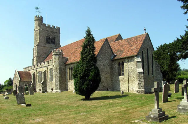
Harrietsham — village in Kent, England, UK.

Wikimedia Commons contributors — see linked file page for photographer and licence licence
Plan your visit
- Typical visit
- 3 h–6 h
- Nearest railway station
- Harrietsham · 0.2 km
- Free entry
- Family-friendly
- Dog-friendly
About
Harrietsham is a town, city, village or settlement in the United Kingdom. Recent population estimates put it at around 1,750 people. Address: ME17. Wikidata describes it as: "village in Kent, England, UK". Coordinates: 51.2433°, 0.6733°.
Photo gallery
Protected designations
- Area of Outstanding Natural Beauty: Kent Downs
Designations sourced from Natural England open data under OGL v3.
From the Wikipedia article
Harrietsham is a rural and industrial village and civil parish in the Maidstone District of Kent, England. According to the United Kingdom Census 2001, it had a population of 1,504, increasing to 2,113 at the 2011 Census. The parish is in the North Downs, 7 miles (10 km) east of Maidstone; it includes the settlements of Marley, Pollhill and Fairbourne.
Excerpt from Wikipedia under CC BY-SA 4.0. See the source article linked in Sources below.
Background
History
Harrietsham is noted in the Domesday Book. In mediaeval times, the manor of Harrietsham passed through a succession of families, including the Adam family of Essex. The manor subsequently passed from Stephen Adam to his sister Eve, wife of John Levett of Hollington, East Sussex. On Levett's death, his widow remarried Laurence Ashburnham, Gent., of Broomham, Sussex, ancestor of the Ashburnham baronets, bringing the manor of Harrietsham into the Ashburnham family. The village contains a number of listed buildings, the most important of which architecturally are Bell Farm House in East Street and the Saxon Church of St John the Baptist, which are both listed Grade I. The village also includes…
Sourced from Wikipedia under CC BY-SA 4.0.
- Coordinates
- 51.2433, 0.6733
- County
- Kent
- District
- Maidstone
- Parish
- Harrietsham
- Postcode
- ME17
- Parliamentary constituency
- Faversham and Mid Kent
- Population
- 1,750
- Nearest railway station
- Harrietsham — 0.2 km
- Official site
- www.neighbourhood.statistics.gov.uk
Sources
- wikidata: Q607701 (CC0)
- wikipedia: Harrietsham (CC BY-SA 4.0)
- commons: St John the Baptist, Harrietsham, Kent - geograph.org.uk - 328356.jpg (CC BY-SA 4.0)
Other places nearby
Loading nearby places…
Nearby
 Flagship📷 5
Farms (open to visitors) · South East England
Bell Farm House, Harrietsham
Bell Farm House, Harrietsham — a Grade I-listed farm in england-south-east, United Kingdom.
 📷 5
📷 5Historic churches · South East England
St John the Baptist's Church, Harrietsham
St John the Baptist's Church, Harrietsham — Grade I listed church in Harrietsham, Maidstone, Kent, England, UK.
 📷 5
📷 5Memorials & monuments · South East England
Brother Percival statue
Brother Percival statue — a memorial in england-south-east, United Kingdom.
 📷 5
📷 5Manor houses · South East England
Fairbourne Manor
Fairbourne Manor — Grade II listed building-listed manor in england-south-east, United Kingdom.
 📷 5
📷 5Manor houses · South East England
Harrietsham Manor
Harrietsham Manor — Grade II* listed building-listed manor in england-south-east, United Kingdom.
Campsites · South East England
Welsummer Camping
Welsummer Camping — a campsite in england south east.
More towns in this region
 Flagship📷 10
Towns & cities · South East England
Aldermaston
Aldermaston — village and civil parish in West Berkshire in England, UK.
 Flagship📷 10
Towns & cities · South East England
Aldingbourne
Aldingbourne — village and civil parish in Arun, West Sussex, UK.
 Flagship📷 10
Towns & cities · South East England
Aldington
Aldington — village and civil parish in the Ashford District of Kent, England.
 Flagship📷 10
Towns & cities · South East England
Aldworth
Aldworth — village and civil parish in the English county of Berkshire.
Frequently asked questions
- Where is Harrietsham?
- Harrietsham is in Kent, South-East England, United Kingdom (postcode ME17), in the parish of Harrietsham.
- Is Harrietsham a protected site?
- Yes — Harrietsham is part of the Kent Downs National Landscape (AONB).
- Is Harrietsham free to visit?
- Yes, Harrietsham is free to enter.
- How do I get to Harrietsham?
- The nearest railway station is Harrietsham, about 0.2 km away. Drivers can navigate to postcode ME17.