Towns & cities · Central Scotland
Gargunnock
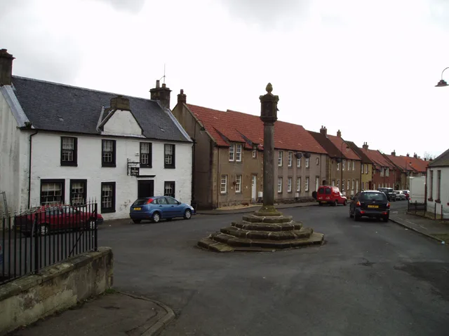
Gargunnock — village in Stirling, Scotland, UK.

Wikimedia Commons contributors — see linked file page for photographer and licence licence
Plan your visit
- Typical visit
- 3 h–6 h
- Nearest railway station
- Bridge of Allan · 8.6 km
- Free entry
- Family-friendly
- Dog-friendly
About
Gargunnock is a town, city, village or settlement in the United Kingdom. Recent population estimates put it at around 740 people. Wikidata describes it as: "village in Stirling, Scotland, UK". Coordinates: 56.1256°, -4.0849°.
Photo gallery
From the Wikipedia article
Gargunnock is a small village in the Stirling council area with an active community trust, seven miles (eleven kilometres) west of Stirling, in Scotland. The census population was 912. It is situated on the south edge of the Carse of Stirling, at the foot of the Gargunnock Hills, part of the Campsie Fells. Several small burns flow down from the Gargunnock Hills The last naturally suitable crossing point on the Forth before reaching Stirling Bridge is situated just outside Gargunnock. This, coupled with the land condition and drainage around the feet of the Gargunnock hills, made Gargunnock the ideal location to build a farming settlement. During the occupation of Scotland, the English posted a battalion in the Peel tower on the outskirts of the village to protect this important ferry. It is believed that William Wallace brought his army through Gargunnock (called Gargowans at the time), setting up fort on the Kier Hill, to take control of this part of the river in advance of the Battle of Stirling Bridge. Bonnie Prince Charlie is also said to have passed through the village on his travels.
Excerpt from Wikipedia under CC BY-SA 4.0. See the source article linked in Sources below.
- Coordinates
- 56.1256, -4.0849
- District
- Stirling
- Postcode
- FK8 3BJ
- Parliamentary constituency
- Stirling and Strathallan
- Population
- 740
- Nearest railway station
- Bridge of Allan — 8.6 km
- Official site
- www.gargunnock.com
Sources
- wikidata: Q1013539 (CC0)
- wikipedia: Gargunnock (CC BY-SA 4.0)
- commons: Gargunnock Village.jpg (CC BY-SA 4.0)
Other places nearby
Loading nearby places…
Nearby
 📷 5
📷 5Historic bridges · Central Scotland
Old Bridge, Gargunnock
Old Bridge, Gargunnock — category C listed building-listed bridge in scotland-central, United Kingdom.
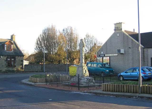
📷 3Memorials & monuments · Central Scotland
Gargunnock War Memorial
Gargunnock War Memorial — a memorial in scotland-central, United Kingdom.
📷 5Historic churches · Central Scotland
Parish Church, Gargunnock
Parish Church, Gargunnock — category B listed building-listed church in scotland-central, United Kingdom.
 📷 3
📷 3Historic houses · Central Scotland
Gargunnock House
Gargunnock House — house in Stirling, Scotland, UK.
 📷 4
📷 4Heritage railway stations · Scottish Highlands
Gargunnock railway station
Gargunnock railway station in Scotland Islands, United Kingdom.
Vineyards · Central Scotland
Leckie
Leckie — a UK vineyard in scotland central, producing English or Welsh wine from cool-climate grape varieties.
More towns in this region
 Flagship📷 3
Towns & cities · Central Scotland
Airth
Airth — village in Falkirk, Scotland, UK.
 Flagship📷 5
Towns & cities · Central Scotland
Avonbridge
Avonbridge — village in Falkirk, Scotland, UK.
 Flagship📷 3
Towns & cities · Central Scotland
Banknock
Banknock — village in Falkirk, Scotland, UK.
 Flagship📷 3
Towns & cities · Central Scotland
Dundee
Dundee — city in Scotland, UK.
Frequently asked questions
- Where is Gargunnock?
- Gargunnock is in central Scotland, United Kingdom (postcode FK8 3BJ).
- Is Gargunnock free to visit?
- Yes, Gargunnock is free to enter.
- How do I get to Gargunnock?
- Drivers can navigate to postcode FK8 3BJ. It sits within the Stirling and Strathallan parliamentary constituency.