Mountains & hills · North Wales
Gallt yr Ogof
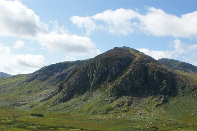
Gallt yr Ogof — Named summit at 763 m.

Wikimedia Commons contributors — see linked file page for photographer and licence licence
Plan your visit
- Typical visit
- 3 h–8 h
- Best time of year
- Late spring – early autumn (May–Oct)
- Nearest railway station
- Roman Bridge · 7.7 km
- Free entry
- Dog-friendly
About
Gallt yr Ogof is a named summit in the United Kingdom. Wikidata describes it as: "Named summit at 763 m.". Coordinates: 53.1079°, -3.9657°.
Photo gallery
From the Wikipedia article
Gallt yr Ogof is a mountain in Snowdonia, North Wales. It is a subsidiary top of Glyder Fawr, and is the most easterly summit over 2,000 feet in the Glyderau mountain range, the most easterly hill being Cefn y Capel. Gallt yr Ogof is 763 metres high. It is a sister peak to Y Foel Goch, which is located on the ridge heading west to Glyder Fach. As its name suggests there is a cave to be found on the cliffs on the precipitous eastern side of the peak.
Excerpt from Wikipedia under CC BY-SA 4.0. See the source article linked in Sources below.
- Coordinates
- 53.1079, -3.9657
- Address
- Conwy, Wales
- Nearest railway station
- Roman Bridge — 7.7 km
- Official site
- www.hill-bagging.co.uk
Sources
- osm: n335172196 (ODbL)
- wikipedia: Gallt yr Ogof (CC BY-SA 4.0)
- commons: Gallt yr Ogof - geograph.org.uk - 1454656.jpg (CC BY-SA 4.0)
Other places nearby
Loading nearby places…
Nearby
 📷 3
📷 3Natural landmarks · North Wales
Gallt yr Ogof
Gallt yr Ogof — mountain (763m) in Conwy County Borough.
 📷 3
📷 3Mountains & hills · North Wales
Y Foel Goch
Y Foel Goch — Named summit at 805 m.
 📷 3
📷 3Natural landmarks · North Wales
Y Foel Goch
Y Foel Goch — mountain (805m) in Conwy County Borough.
Campsites · North Wales
Gwern Gôf Isaf Campsite & Bunkhouses
Gwern Gôf Isaf Campsite & Bunkhouses — a campsite in wales north.
 📷 4
📷 4Reservoirs & lochs · North Wales
Dyffryn Mymbyr
Dyffryn Mymbyr is a valley in Snowdonia, in north-west Wales, approximately 5 miles (8.0 km) in length, and leading up from Capel Curig to the Pen-y-Gwryd hotel. The river Nantygwryd, originally calle
Campsites · North Wales
Garth Farm
Garth Farm — a campsite in wales north.
More mountains in this region
 📷 5
📷 5Mountains & hills · North Wales
Cemlyn Bay and lagoon
Cemlyn Bay and lagoon — Site of Special Scientific Interest in Wales.
 📷 3
📷 3Mountains & hills · North Wales
Aberffraw Bay
Aberffraw Bay — bay on the west coast of Anglesey, in Wales, UK.
 📷 3
📷 3Mountains & hills · North Wales
Allt-fawr
Allt-fawr — Named summit at 698 m.
 📷 3
📷 3Mountains & hills · North Wales
Aran Benllyn
Aran Benllyn — Named summit at 884 m.
Frequently asked questions
- Where is Gallt yr Ogof?
- Gallt yr Ogof is in North Wales, United Kingdom.
- Is Gallt yr Ogof free to visit?
- Yes, Gallt yr Ogof is free to enter.
- How do I get to Gallt yr Ogof?
- The nearest railway station is Roman Bridge, about 7.7 km away.