Historic churches · Scottish Highlands
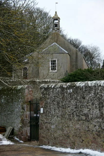
Former Parish Church, Main Road, Cardross
Former Parish Church, Main Road, Cardross — category B listed building-listed church in scotland-highlands, United Kingdom.

Lairich Rig — CC BY-SA 2.0 via Wikimedia Commons licence
Plan your visit
- Typical visit
- 30 min–1 h
- Free entry
About
Former Parish Church, Main Road, Cardross is a category B listed building-listed church in scotland-highlands, United Kingdom, registered on the Historic Environment Scotland register (entry LB1152). Listed status protects buildings and structures of special architectural or historic interest. See the linked Wikipedia article for further details.
Photo gallery
Heritage listing
Category B Date Added 14/05/1971 Local Authority Argyll And Bute Planning Authority Argyll And Bute Parish Cardross NGR NS 34930 77284 Coordinates 234930, 677284 — James Dempster, 1826-7, bombed 1941, ruin preserved as monument in 1954. Gothic tower with flanking buttressed bays; wall to cill level delineating original rectangular plan of church. Ashlar-faced with ashlar margins and dressings; battered base course. NW ELEVATION AND TOWER: 2-stage tower with crenellated parapet; angle buttresses, spikey pinnacles with crocketted finials. Main elevation, pointed arch, 3-light, plate traceried windows symmetrically disposed at each stage; string course. Moulded pointed arch door on right return, now blocked, possibly later hoodmould with red sandstone carved mask labelstops; plaque with floreate boss above; window at upper stage (detailed as above). Symmetrical flanking bays each with hoodmoulded lancet and ashlar parapet to skews. Low square-plan block in re-entrant angle to left, former boiler. SW AND NE ELEVATIONS: original wall partially carried around, remains of chamfered window surround, part of hoodmould. 1954 wall carried to cill level mirroring the original walls. SE (INNER) ELEVATION: rubble inner wall of tower, door at ground, partially blocked; 3-centred pointed window blocked at upper level. GATES, GATEPIERS AND BOUNDARY WALL: gabletted ashlar gatepiers with recessed panels, arrowhead cast-iron gates, wrought-iron overthrow with lantern. Squared sandstone rubble wall with some harl pointing and later cement pointing. GRAVEYARD AND MONUMENTS: number of interesting 17th, 18th and 19th century grave monuments. BURIAL ENCLOSURES: pair of early 19th century rectangular-plan identical burial enclosures side by side against NW wall; ashlar; base course; sandstone ea
From Historic Environment Scotland under OGL v3.
Place summary
The Former Parish Church is located on Main Road in Cardross, within the Scottish Highlands. This structure is designated as a category B listed building, recognising its architectural and historical significance.
AI-generated from the structured facts on this page (operator, designation, listing, era). Not a substitute for visiting.
- Coordinates
- 55.9601, -4.6458
- District
- Argyll and Bute
- Postcode
- G82 5JX
- Parliamentary constituency
- Argyll, Bute and South Lochaber
Sources
- wikidata: Q17774426 (CC0)
Other places nearby
Loading nearby places…
Nearby
 📷 5
📷 5Historic bridges · Scottish Highlands
Moore's Bridge
Moore's Bridge — category C listed building-listed bridge in scotland-highlands, United Kingdom.
 📷 3
📷 3Memorials & monuments · Scottish Highlands
John Reginald Noble Graham VC Memorial
John Reginald Noble Graham VC Memorial — a memorial in scotland-highlands, United Kingdom.
📷 5Memorials & monuments · Scottish Highlands
War Memorial, Main Road, Cardross
War Memorial, Main Road, Cardross — category B listed building-listed memorial in scotland-highlands, United Kingdom.
 📷 5
📷 5Historic churches · Scottish Highlands
Parish Church, Station Road, Cardross
Parish Church, Station Road, Cardross — category B listed building-listed church in scotland-highlands, United Kingdom.
 📷 5
📷 5Towns & cities · Scottish Highlands
Cardross
Cardross — village in Argyll and Bute, Scotland.
 📷 3
📷 3Historic houses · Scottish Highlands
Murray's Farm
Murray's Farm — a historic house in scotland-highlands, United Kingdom.
More places in this region
 📷 3
📷 3Historic churches · Scottish Highlands
Airlie Parish Kirk
Airlie Parish Kirk — church in Angus, Scotland, UK.
 📷 3
📷 3Historic churches · Scottish Highlands
Arbuthnott, Bervie & Kinneff Parish Church
Arbuthnott, Bervie & Kinneff Parish Church — church in Aberdeenshire, Scotland, UK.
 📷 3
📷 3Historic churches · Scottish Highlands
Arnisdale Free Church
Arnisdale Free Church — church in Highland, Scotland, UK.
 📷 3
📷 3Historic churches · Scottish Highlands
Aultbea Free Church
Aultbea Free Church — church in Aultbea, UK.
Frequently asked questions
- Where is Former Parish Church, Main Road, Cardross?
- Former Parish Church, Main Road, Cardross is in the Scottish Highlands, United Kingdom (postcode G82 5JX).
- Is Former Parish Church, Main Road, Cardross a listed building?
- Former Parish Church, Main Road, Cardross is officially recognised as category B listed building listed.
- Is Former Parish Church, Main Road, Cardross free to visit?
- Yes, Former Parish Church, Main Road, Cardross is free to enter.
- How do I get to Former Parish Church, Main Road, Cardross?
- Drivers can navigate to postcode G82 5JX. It sits within the Argyll, Bute and South Lochaber parliamentary constituency.