Archaeological sites · East Midlands
Embanked stone circle known as Wet Withens, and adjacent cairn
Embanked stone circle known as Wet Withens, and adjacent cairn — Stone circle in Derbyshire, England, UK.

Wikimedia Commons contributors — see linked file page for photographer and licence licence
Plan your visit
- Typical visit
- 45 min–1.5 h
- Nearest railway station
- Hathersage · 2.2 km
- Free entry
- Dog-friendly
About
Embanked stone circle known as Wet Withens, and adjacent cairn is an archaeological site in the United Kingdom. Heritage designation: scheduled monument. Wikidata describes it as: "Stone circle in Derbyshire, England, UK". Coordinates: 53.3075°, -1.6631°.
Photo gallery
Protected designations
- Site of Special Scientific Interest: Eastern Peak District Moors SSSI
Designations sourced from Natural England open data under OGL v3.
From the Wikipedia article
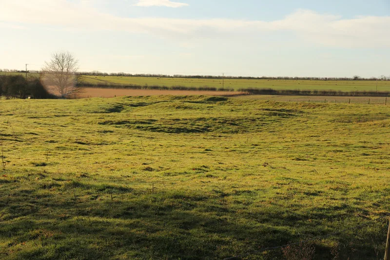
Wet Withens is a Bronze Age henge on Eyam Moor in the Derbyshire Peak District, England. The prehistoric circle of 10 upright stones (orthostats) is a protected Scheduled Monument. It is sometimes known as Wet Withers (Old English for 'the wet land where willows grew'). On gritstone moorland over 300 metres above sea level, the site has clear views of the valley of the River Derwent and Higger Tor. The site is well away from public footpaths but is on "Open Access" land following the Countryside and Rights of Way Act 2000. The earthen bank of Wet Withens is over 30m in diameter, making it the largest embanked stone circle in Derbyshire. Most of the stones of the ring are quite hidden amongst the heather and reeds. 7 stones are still upright but some of those are leaning inwards. The 'Chair Stone' (70cm high) is the tallest and most prominent stone with a ledge cut out of its face, appearing as a seat. There could have been up to 18 stones originally if the stones had been spaced out evenly. About 10m north of the henge is a large stone cairn (known as Eyam Moor Barrow) about 27m long and 1m high. The cairn has been damaged from quarrying and/or excavation activity over the centuries. Near the middle of the cairn is an unusual cup-marked stone. The cairn's shape indicates that it was likely to have been a prehistoric burial barrow. Wet Withens is also known as Eyam Moor 1 because there are 2 smaller stone circles about 650m to the east, which are also Scheduled Monuments: Eyam Moor 2 and Eyam Moor 3. There are a number of other ancient henges in Derbyshire including Arbor Low, The Bull Ring, Doll Tor, Hordron Edge, Nine Stone Close and Twyford Henge.
Excerpt from Wikipedia under CC BY-SA 4.0. See the source article linked in Sources below.
- Coordinates
- 53.3075, -1.6631
- County
- Derbyshire
- District
- Derbyshire Dales
- Parish
- Grindleford
- Postcode
- S32 2HL
- Parliamentary constituency
- Derbyshire Dales
- Nearest railway station
- Hathersage — 2.2 km
Sources
- wikidata: Q17676006 (CC0)
- wikipedia: Wet Withens (CC BY-SA 4.0)
- commons: Eyam Moor cairn - geograph.org.uk - 1220616.jpg (CC BY-SA 4.0)
Other places nearby
Loading nearby places…
Nearby
 📷 3
📷 3Archaeological sites · East Midlands
Wet Withens
Wet Withens — a archaeological in england-east-midlands, United Kingdom.
 📷 4
📷 4Historic houses · East Midlands
Highlow Hall
Highlow Hall — Grade II* listed house in Highlow, Derbyshire Dales, England, UK.
 📷 4
📷 4Memorials & monuments · East Midlands
Mompesson's Well
Mompesson's Well is a memorial in the United Kingdom.
 📷 3
📷 3Natural landmarks · East Midlands
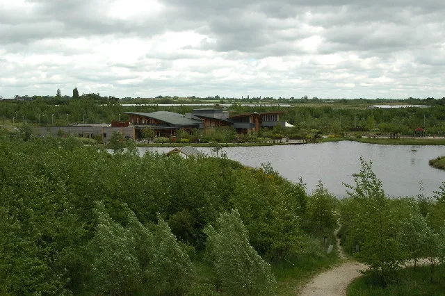
David Mellor Visitor Centre
David Mellor Visitor Centre — a natural landmark in england-east-midlands, United Kingdom.
Hostels · East Midlands
Eyam youth hostel
Eyam youth hostel — a hostel in england east midlands. Brand: Youth Hostels Association.
 📷 5
📷 5Chapels · East Midlands
Padley Chapel
Padley Chapel — Grade I listed chapel in Derbyshire Dales, United Kingdom.
More archaeological sites in this region
 Flagship📷 5
Archaeological sites · East Midlands
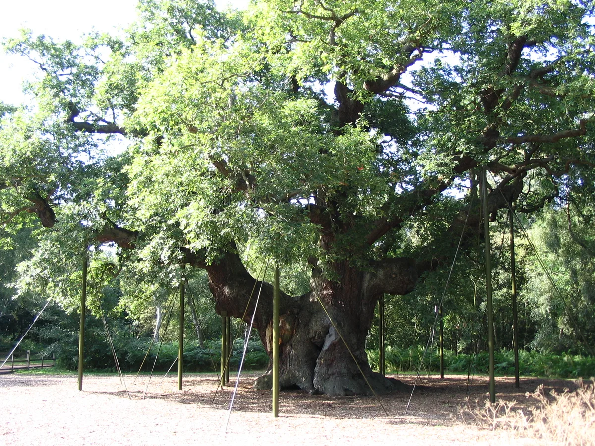
Sherwood Forest
Sherwood Forest is a archaeological site in the United Kingdom.
 Flagship📷 5
Archaeological sites · East Midlands
The National Forest
The National Forest — environmental project in central England.
 📷 3
📷 3Archaeological sites · East Midlands
Appleton medieval and early post-medieval settlement
Appleton medieval and early post-medieval settlement — archaeological site in Flitcham with Appleton, King's Lynn and West Norfolk, England, UK.
 📷 3
📷 3Archaeological sites · East Midlands
Brauncewell medieval village
Brauncewell medieval village — archaeological site in Cranwell, Brauncewell and Byard's Leap, North Kesteven, England, UK.
Frequently asked questions
- Where is Embanked stone circle known as Wet Withens, and adjacent cairn?
- Embanked stone circle known as Wet Withens, and adjacent cairn is in Derbyshire, the East Midlands, United Kingdom (postcode S32 2HL), in the parish of Grindleford.
- Is Embanked stone circle known as Wet Withens, and adjacent cairn a listed building?
- Embanked stone circle known as Wet Withens, and adjacent cairn is officially recognised as scheduled monument listed.
- Is Embanked stone circle known as Wet Withens, and adjacent cairn a protected site?
- Yes — Embanked stone circle known as Wet Withens, and adjacent cairn is part of the Eastern Peak District Moors SSSI Site of Special Scientific Interest.
- How do I get to Embanked stone circle known as Wet Withens, and adjacent cairn?
- The nearest railway station is Hathersage, about 2.2 km away. Drivers can navigate to postcode S32 2HL.