Natural landmarks · North West England
Elter Water
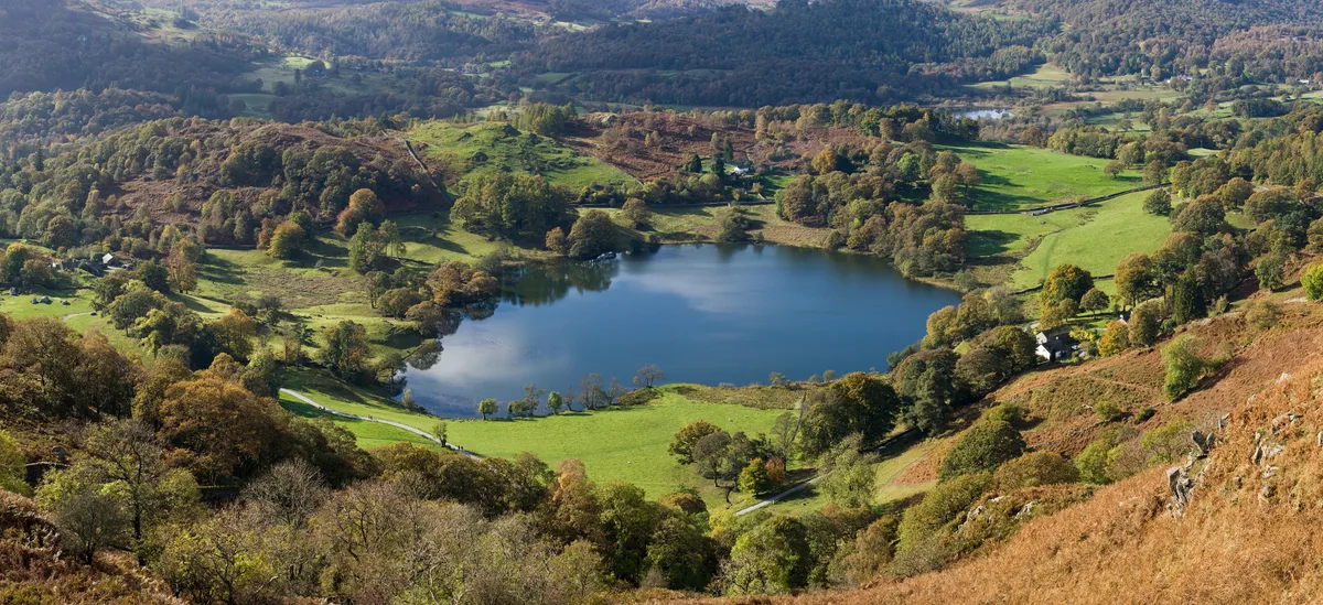
Elter Water — lake in the United Kingdom.

Wikimedia Commons contributors — see linked file page for photographer and licence licence
Plan your visit
- Typical visit
- 1 h–2 h
- Nearest railway station
- Windermere · 9.6 km
- Free entry
- Dog-friendly
About
Elter Water is a named natural landmark in the United Kingdom. Heritage designation: Site of Special Scientific Interest. Wikidata describes it as: "lake in the United Kingdom". Coordinates: 54.4275°, -3.0259°.
Photo gallery
Protected designations
- Site of Special Scientific Interest: Elterwater SSSI
- Site of Special Scientific Interest: River Eden and Tributaries SSSI
Designations sourced from Natural England open data under OGL v3.
From the Wikipedia article
Elter Water is a small lake in the Lake District in North West England, half a mile southeast of the village of the same name. It has a length of 0.62 miles (1.00 km), maximum width of approximately 0.24 miles (0.39 km), a maximum depth of 7 metres (7.7 yd), and an area of 0.16 square kilometres (0.062 sq mi). Its outflow is the River Brathay, which flows south to join Windermere near Ambleside. Windermere is itself drained by the River Leven, which flows into Morecambe Bay. The lake is in the unitary authority of Westmorland and Furness and the ceremonial county of Cumbria. Elter Water forms part of the boundary between the historic counties of Lancashire and Westmorland, and is the northernmost point of the former.
Excerpt from Wikipedia under CC BY-SA 4.0. See the source article linked in Sources below.
- Coordinates
- 54.4275, -3.0259
- District
- Westmorland and Furness
- Parish
- Lakes
- Postcode
- LA22 9HL
- Parliamentary constituency
- Westmorland and Lonsdale
- Nearest railway station
- Windermere — 9.6 km
Sources
- wikidata: Q1543979 (CC0)
- wikipedia: Elter Water (CC BY-SA 4.0)
- commons: Elterwater and Langdale.jpg (CC BY-SA 4.0)
Other places nearby
Loading nearby places…
Nearby
 📷 3
📷 3Natural landmarks · North West England
Loughrigg Tarn
Loughrigg Tarn — lake in the Lake District, Cumbria, England.
Hostels · North West England
Elterwater Hostel
Elterwater Hostel — a hostel in england north west.
 📷 4
📷 4Historic bridges · North West England
Elterwater Bridge
Elterwater Bridge is a historic bridge in the United Kingdom.
 📷 4
📷 4Towns & cities · North West England
Elterwater
Elterwater — village in Cumbria, United Kingdom.
 📷 3
📷 3Historic bridges · North West England
Skelwith Bridge (That Part Within Lakes District)
Skelwith Bridge (That Part Within Lakes District) — Grade II listed building-listed bridge in england-north-west, United Kingdom.
Campsites · North West England
Tarn Foot Farm Campsite
Tarn Foot Farm Campsite — a campsite in england north west.
More natural landmarks in this region
 ★ Iconic📷 4
Natural landmarks · North West England
Coniston Water
Lake District lake — Swallows and Amazons setting and Donald Campbell water-speed history.
 📷 3
📷 3Natural landmarks · North West England
Esthwaite Water
Esthwaite Water — lake in the United Kingdom.
 Flagship📷 5
Natural landmarks · North West England
Semerwater
Semerwater — lake in North Yorkshire, England, UK.
 Flagship📷 3
Natural landmarks · North West England
Stickle Tarn
Stickle Tarn — lake near Harrison Stickle, Langdale, Cumbria, United Kingdom.
Frequently asked questions
- Where is Elter Water?
- Elter Water is in North-West England, United Kingdom (postcode LA22 9HL), in the parish of Lakes.
- Is Elter Water a listed building?
- Elter Water is officially recognised as Site of Special Scientific Interest listed.
- Is Elter Water a protected site?
- Yes — Elter Water is part of the Elterwater SSSI Site of Special Scientific Interest and the River Eden and Tributaries SSSI Site of Special Scientific Interest.
- Is Elter Water free to visit?
- Yes, Elter Water is free to enter.
- How do I get to Elter Water?
- Drivers can navigate to postcode LA22 9HL. It sits within the Westmorland and Lonsdale parliamentary constituency.