Hill forts · Scottish Highlands
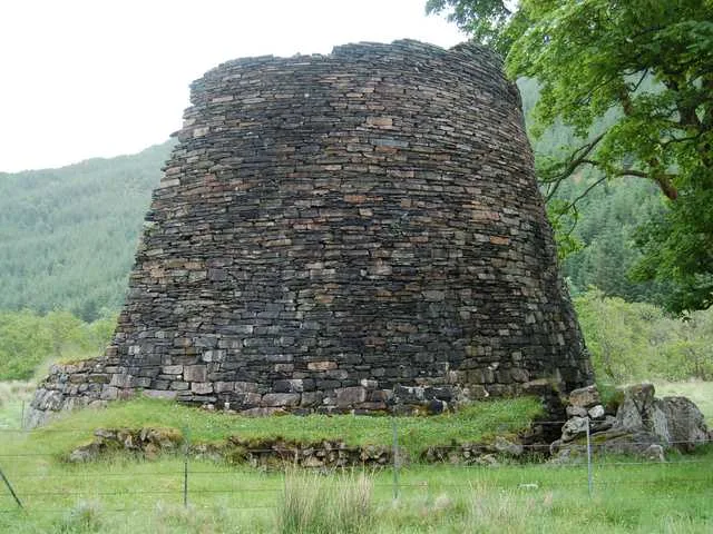
Dun Troddan
Dun Troddan — iron-age broch located about 5 kilometres southeast of the village of Glenelg, in Scotland, UK.

Wikimedia Commons contributors — see linked file page for photographer and licence licence
Plan your visit
- Typical visit
- 1 h–2 h
- Free entry
- Family-friendly
- Dog-friendly
- Limited wheelchair access
About
Dun Troddan is a hill fort in the United Kingdom. Heritage designation: part of a Scheduled Monument. Owned by Historic Environment Scotland. Managed by Historic Environment Scotland. Part of Glenelg Brochs. Wikidata describes it as: "iron-age broch located about 5 kilometres southeast of the village of Glenelg, in Scotland, UK". Coordinates: 57.1942°, -5.5868°.
Photo gallery
From the Wikipedia article
Dun Troddan (Scottish Gaelic: Dùn Trodan) is an iron-age broch located about 5 kilometres (3.1 mi) southeast of the village of Kirkton,Glenelg, Highland, in Scotland. It is one of the best-preserved brochs in Scotland.
Excerpt from Wikipedia under CC BY-SA 4.0. See the source article linked in Sources below.
Background
History
The brochs date from the Iron Age, approximately 2000 years ago. Dun Troddan was first sketched in about 1720, when it was still an intact tower. It is thought that it was over 12 m high in 1720, and it was described as being "by far the most entire of any in that Country". It was robbed for stone in 1722 during the construction of Bernera Barracks in Glenelg. The broch was visited by Thomas Pennant in 1772, and it was still a substantial structure, although it had lost the upper gallery by this time. It was cleared of "debris" without any supervision and consolidated by the Office of Works in the years between 1914 and 1920. The broch is now in the care of Historic Environment Scotland.
Description
The broch consists of a drystone tower which measures around 17.5 m in diameter, and currently stands to a maximum height of 7 m. Built into the hearth is a broken quern-stone. The central court is an almost perfect circle with a diameter of 8.56 m. An internal doorway in the remaining high part of the wall provides access to a stairway. From here it is possible to ascend nine stairs to a first floor landing. The landing is 5.7 m long, at a height of 2.4 m above the central court. At the end of the landing can be seen the first step which would have led up the next flight of stairs.
Sourced from Wikipedia under CC BY-SA 4.0.
- Coordinates
- 57.1942, -5.5868
- District
- Highland
- Postcode
- IV40 8JX
- Parliamentary constituency
- Inverness, Skye and West Ross-shire
- Official site
- www.historicenvironment.scot
Sources
- wikidata: Q2131824 (CC0)
- wikipedia: Dun Troddan (CC BY-SA 4.0)
- commons: Dun Troddan - geograph.org.uk - 8424.jpg (CC BY-SA 4.0)
Other places nearby
Loading nearby places…
Nearby
 📷 3
📷 3Natural landmarks · Scottish Highlands
Dun Troddan (Broch)
Dun Troddan (Broch) — a other in scotland-highlands, United Kingdom.
 📷 3
📷 3Natural landmarks · Scottish Highlands
Dun Telve (Broch)
Dun Telve (Broch) — a other in scotland-highlands, United Kingdom.
 📷 5
📷 5Hill forts · Scottish Highlands
Dun Telve
Dun Telve — iron-age broch located about 4 kilometres southeast of the village of Glenelg, in Scotland, UK.
 📷 3
📷 3Castles · Scottish Highlands
Castle Chalamine, dun site
Castle Chalamine, dun site — a castle in scotland-highlands, United Kingdom.
 📷 4
📷 4Other places · Scottish Highlands
Dun Grugaig
Dun Grugaig in Scotland Islands, United Kingdom.
📷 3Archaeological sites · Scottish Highlands
Dun Grugaig, dun site
Dun Grugaig, dun site — a archaeological in scotland-highlands, United Kingdom.
More places run by Historic Environment Scotland
 📷 5
📷 5Castles · Scottish Highlands
Castle Sween
Castle Sween — stone castle on the eastern shore of Loch Sween, Knapdale.
 📷 5
📷 5Castles · Scottish Highlands
Corgarff Castle
Corgarff Castle — castle and military museum in Aberdeenshire, Scotland, UK.
 📷 3
📷 3Museums · Scottish Highlands
Duff House
Duff House — estate house in Banff, Aberdeenshire, Scotland, UK.
 📷 3
📷 3Castles · Scottish Highlands
Dumbarton Castle
Dumbarton Castle — castle in West Dunbartonshire, Scotland, UK.
More places in this region
 📷 3
📷 3Hill forts · Scottish Highlands
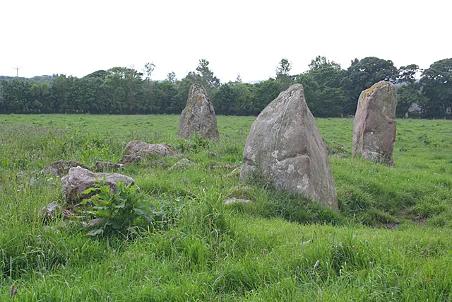
Aquhorthies stone circle
Aquhorthies stone circle — architectural structure in Aberdeenshire, Scotland, UK.
 📷 3
📷 3Hill forts · Scottish Highlands
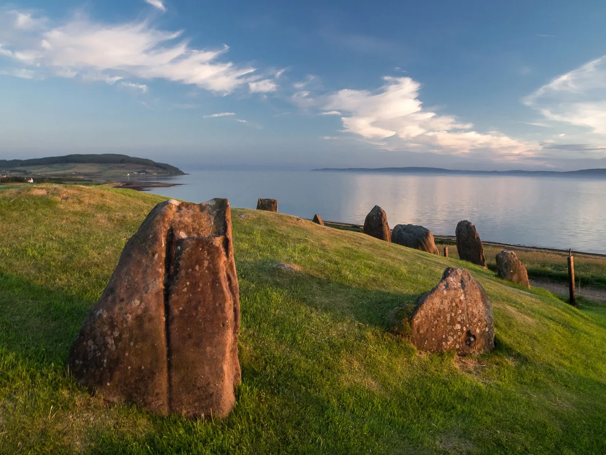
Auchagallon Stone Circle
Auchagallon Stone Circle — archaeological site in North Ayrshire, Scotland, UK.
 📷 3
📷 3Hill forts · Scottish Highlands
Auchinhove
Auchinhove — archaeological site in Moray, Scotland, UK.
 📷 3
📷 3Hill forts · Scottish Highlands
Balbridie
Balbridie — Neolithic timber hall remains in Aberdeenshire, Scotland, UK.
Frequently asked questions
- Where is Dun Troddan?
- Dun Troddan is in the Scottish Highlands, United Kingdom (postcode IV40 8JX).
- Who runs Dun Troddan?
- Dun Troddan is operated by Historic Environment Scotland.
- Is Dun Troddan a listed building?
- Dun Troddan is officially recognised as part of a Scheduled Monument listed.
- Is Dun Troddan free to visit?
- Yes, Dun Troddan is free to enter.
- How do I get to Dun Troddan?
- Drivers can navigate to postcode IV40 8JX. It sits within the Inverness, Skye and West Ross-shire parliamentary constituency.