Mountains & hills · South East England
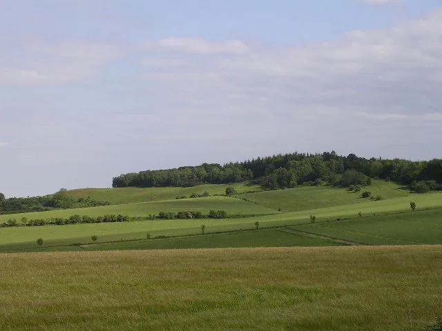
Damerham Knoll
Damerham Knoll — Named summit at 146 m.

Wikimedia Commons contributors — see linked file page for photographer and licence licence
Plan your visit
- Typical visit
- 3 h–8 h
- Best time of year
- Late spring – early autumn (May–Oct)
- Free entry
- Dog-friendly
About
Damerham Knoll is a named summit in the United Kingdom. Wikidata describes it as: "Named summit at 146 m.". Coordinates: 50.9661°, -1.8610°.
Photo gallery
Protected designations
- Site of Special Scientific Interest: River Avon System SSSI
- Area of Outstanding Natural Beauty: Cranborne Chase & West Wiltshire Downs
Designations sourced from Natural England open data under OGL v3.
From the Wikipedia article
Knoll Camp, or Damerham Knoll, is the site of an Iron Age univallate hill fort located in Hampshire. The fort comprises a circular earthwork containing about four acres. There is a single ditch with inner rampart and traces of counter scarp bank. The site is a scheduled ancient monument no.118. Grim's Ditch also runs throughout this area. The footpath/bridleway from the nearby long barrows of Grans Barrow and Knap Barrow runs southeast along the ridge through the centre of the hill fort, leaving through the original SE entrance, and you could easily miss the ditch and bank as you cross it. The interior is thickly wooded and brambled. There is also a probable Iron Age Cross Ridge close by, described as Damerham Knoll, 50m west of Knoll Camp and comprises a shallow ditch with fragmentary remains of a bank on the west side. grid reference SU098185
Excerpt from Wikipedia under CC BY-SA 4.0. See the source article linked in Sources below.
- Coordinates
- 50.9661, -1.8610
- County
- Hampshire
- District
- New Forest
- Parish
- Damerham
- Postcode
- SP6 3JL
- Parliamentary constituency
- New Forest West
Sources
- osm: n9595731167 (ODbL)
- wikipedia: Knoll Camp (CC BY-SA 4.0)
- commons: Damerham Knoll - geograph.org.uk - 24134.jpg (CC BY-SA 4.0)
Other places nearby
Loading nearby places…
Nearby
 📷 5
📷 5Archaeological sites · South East England
Grim's Ditch
Grim's Ditch — a archaeological in england-south-east, United Kingdom.
 📷 5
📷 5Hill forts · South East England
Knoll Camp
Knoll Camp — hillfort in Hampshire, England, UK.
Mountain bike trails · South East England
Fordingbridge Off Road Cycle Trail
Fordingbridge Off Road Cycle Trail — a mtb trail in england south east.
Mountain bike trails · South East England
Fordingbridge Off Road Cycle Trail (Shortcut)
Fordingbridge Off Road Cycle Trail (Shortcut) — a mtb trail in england south east.
 📷 5
📷 5Burial mounds & barrows · South East England
Gran's Barrow
Gran's Barrow — a burial mound in england-south-east, United Kingdom.
 📷 5
📷 5Museums · South East England
Rockbourne
Rockbourne — a museum in england-south-east, United Kingdom.
More mountains in this region
 📷 5
📷 5Mountains & hills · South East England
Alum Bay
Alum Bay is a mountain or hill in the United Kingdom.
 📷 5
📷 5Mountains & hills · South East England
Arish Mell
Arish Mell — bay in Dorset, England.
 📷 5
📷 5Mountains & hills · South East England
Balaclava Bay
Balaclava Bay — bay in Dorset, England.
 📷 5
📷 5Mountains & hills · South East England
Balch Cave
Balch Cave — Cave in Somerset, England.
Frequently asked questions
- Where is Damerham Knoll?
- Damerham Knoll is in Hampshire, South-East England, United Kingdom (postcode SP6 3JL), in the parish of Damerham.
- Is Damerham Knoll a protected site?
- Yes — Damerham Knoll is part of the River Avon System SSSI Site of Special Scientific Interest and the Cranborne Chase & West Wiltshire Downs National Landscape (AONB).
- Is Damerham Knoll free to visit?
- Yes, Damerham Knoll is free to enter.
- How do I get to Damerham Knoll?
- Drivers can navigate to postcode SP6 3JL. It sits within the New Forest West parliamentary constituency.