Towns & cities · Central Scotland
Currie
Also known as: Curraich
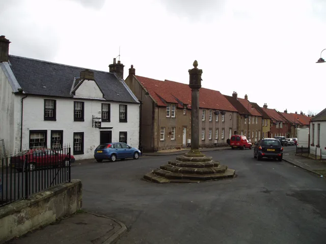
Currie — village in Edinburgh, Scotland.

Wikimedia Commons contributors — see linked file page for photographer and licence licence
Plan your visit
- Typical visit
- 3 h–6 h
- Nearest railway station
- Curriehill · 0.9 km
- Free entry
- Family-friendly
- Dog-friendly
- Wheelchair accessible
About
Currie is a town, city, village or settlement in the United Kingdom. Recent population estimates put it at around 7,494 people. Part of Edinburgh. Wikidata describes it as: "village in Edinburgh, Scotland". Coordinates: 55.8960°, -3.3074°.
Photo gallery
From the Wikipedia article
Currie is a village and suburb on the outskirts of Edinburgh, Scotland, situated 7 miles (11 kilometres) south west of the city centre. Formerly within the County of Midlothian, it now falls within the jurisdiction of the City of Edinburgh Council. It is situated between Juniper Green to the northeast and Balerno to the southwest. It gives its name to a civil parish. In 2001, the population of Currie was 8,550 and it contained 3,454 houses.
Excerpt from Wikipedia under CC BY-SA 4.0. See the source article linked in Sources below.
Background
History
The earliest record of a settlement in the Currie area is a Bronze Age razor (1800 BC) found at Kinleith Mill and the stone cists (500 BC) at Duncan's Belt and Blinkbonny. There are a few mentions of this area in medieval and early modern documents. One of the first is when Robert of Kildeleith became Chancellor of Scotland in 1249. Kildeleith means Chapel by the Leith, and survives today as Kinleith. Robert the Bruce gave Riccarton as a wedding present in 1315 and in 1392 the land passed to the family of Bishop Wardlaw. In 1612 the land went to Ludovic Craig, a Senator of the College of Justice. In 1818 it passed to the female line and became the property of the Gibson-Craigs. There has…
Sourced from Wikipedia under CC BY-SA 4.0.
- Coordinates
- 55.8960, -3.3074
- District
- City of Edinburgh
- Postcode
- EH14 6AL
- Parliamentary constituency
- Edinburgh South West
- Population
- 7,494
- Nearest railway station
- Curriehill — 0.9 km
Sources
- wikidata: Q1144879 (CC0)
- wikipedia: Currie, Edinburgh (CC BY-SA 4.0)
- commons: Currie Kirk, Midlothian.JPG (CC BY-SA 4.0)
Other places nearby
Loading nearby places…
Nearby
 📷 3
📷 3Memorials & monuments · Central Scotland
Dougal Haston Memorial Stone
Dougal Haston Memorial Stone — a memorial in scotland-central, United Kingdom.
 📷 3
📷 3Memorials & monuments · Central Scotland
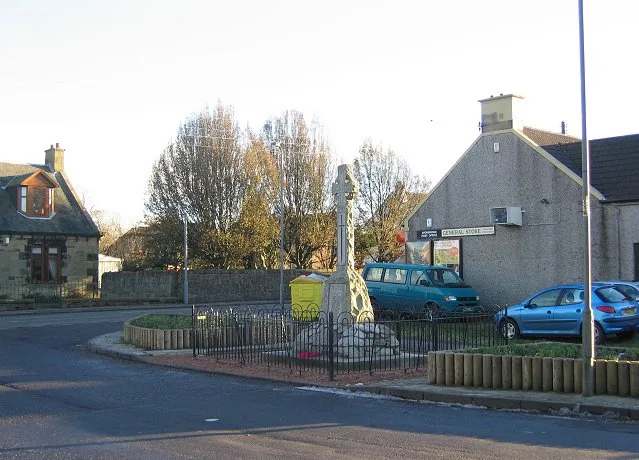
Currie War Memorial
Currie War Memorial — a memorial in scotland-central, United Kingdom.
 📷 5
📷 5Historic churches · Central Scotland
Currie Kirk, Kirkgate, Currie
Currie Kirk, Kirkgate, Currie — category A listed building-listed church in scotland-central, United Kingdom.
 📷 3
📷 3Memorials & monuments · Central Scotland
Gibson-Craig Memorial Hall
Gibson-Craig Memorial Hall — a memorial in scotland-central, United Kingdom.
 📷 3
📷 3Historic bridges · Central Scotland
Blinkbonny Road
Blinkbonny Road is a historic bridge in the United Kingdom.
 📷 5
📷 5Historic bridges · Central Scotland
East Mills Bridge
East Mills Bridge — category B listed building-listed bridge in scotland-central, United Kingdom.
More towns in this region
 Flagship📷 3
Towns & cities · Central Scotland
Airth
Airth — village in Falkirk, Scotland, UK.
 Flagship📷 5
Towns & cities · Central Scotland
Avonbridge
Avonbridge — village in Falkirk, Scotland, UK.
 Flagship📷 3
Towns & cities · Central Scotland
Banknock
Banknock — village in Falkirk, Scotland, UK.
 Flagship📷 3
Towns & cities · Central Scotland
Dundee
Dundee — city in Scotland, UK.
Frequently asked questions
- Where is Currie?
- Currie is in central Scotland, United Kingdom (postcode EH14 6AL).
- Is Currie free to visit?
- Yes, Currie is free to enter.
- How do I get to Currie?
- The nearest railway station is Curriehill, about 0.9 km away. Drivers can navigate to postcode EH14 6AL.