Mountains & hills · South East England
Combe Hill
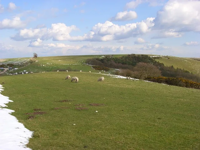
Combe Hill — Named summit at 293 m.

Wikimedia Commons contributors — see linked file page for photographer and licence licence
Plan your visit
- Typical visit
- 3 h–8 h
- Best time of year
- Late spring – early autumn (May–Oct)
- Nearest railway station
- Kintbury · 6.7 km
- Free entry
- Dog-friendly
About
Combe Hill is a named summit in the United Kingdom. Wikidata describes it as: "Named summit at 293 m.". Coordinates: 51.3425°, -1.4535°.
Photo gallery
Protected designations
- Area of Outstanding Natural Beauty: Cotswolds
- Area of Outstanding Natural Beauty: North Wessex Downs
Designations sourced from Natural England open data under OGL v3.
From the Wikipedia article
Combe Hill is a summit in Berkshire, England, with a maximum elevation of 293 m (961 ft). It lies around 1 mile (1.6 km) to the south-east of Walbury Hill, the county top of Berkshire, which is 297 m (974 ft) high. The hill is about 7 miles (11 km) southwest of Newbury on the Hampshire/Berkshire border and is part of the north-facing scarp of the North Hampshire Downs, a chalk ridge within the North Wessex Downs Area of Outstanding Natural Beauty. The hill lies within the civil parishes of Combe (which includes the summit), East Woodhay and Faccombe. Combe is within the unitary authority area of West Berkshire and the ceremonial county of Berkshire, East Woodhay is within the district of Basingstoke and Deane in the administrative county of Hampshire, and Faccombe is in the Hampshire district of Test Valley.
Excerpt from Wikipedia under CC BY-SA 4.0. See the source article linked in Sources below.
- Coordinates
- 51.3425, -1.4535
- District
- West Berkshire
- Parish
- Combe
- Postcode
- RG17 9EG
- Parliamentary constituency
- Newbury
- Nearest railway station
- Kintbury — 6.7 km
Sources
- osm: n2418351224 (ODbL)
- wikipedia: Combe Hill, Berkshire (CC BY-SA 4.0)
- commons: Combe Hill - geograph.org.uk - 2393448.jpg (CC BY-SA 4.0)
Other places nearby
Loading nearby places…
Nearby
 📷 5
📷 5Historic churches · South East England
Church of St Swithin
Church of St Swithin — Grade I listed church in Combe, West Berkshire, England, UK.
 📷 5
📷 5Mountains & hills · South East England
Walbury Hill
Walbury Hill — Named summit at 297 m.
 📷 5
📷 5Natural landmarks · South East England
Walbury Hill
Walbury Hill — hill in, and highest point of, the English county of Berkshire.
Vineyards · South East England
Walbury Camp
Walbury Camp — a UK vineyard in england south east, producing English or Welsh wine from cool-climate grape varieties.
 📷 5
📷 5Mountains & hills · South East England
Pilot Hill
Pilot Hill — Named summit at 286 m.
 📷 5
📷 5Memorials & monuments · South East England
World War II Assault on Merville Battery
World War II Assault on Merville Battery is a memorial in the United Kingdom.
More mountains in this region
 📷 5
📷 5Mountains & hills · South East England
Alum Bay
Alum Bay is a mountain or hill in the United Kingdom.
 📷 5
📷 5Mountains & hills · South East England
Arish Mell
Arish Mell — bay in Dorset, England.
 📷 5
📷 5Mountains & hills · South East England
Balaclava Bay
Balaclava Bay — bay in Dorset, England.
 📷 5
📷 5Mountains & hills · South East England
Balch Cave
Balch Cave — Cave in Somerset, England.
Frequently asked questions
- Where is Combe Hill?
- Combe Hill is in South-East England, United Kingdom (postcode RG17 9EG), in the parish of Combe.
- Is Combe Hill a protected site?
- Yes — Combe Hill is part of the Cotswolds National Landscape (AONB) and the North Wessex Downs National Landscape (AONB).
- Is Combe Hill free to visit?
- Yes, Combe Hill is free to enter.
- How do I get to Combe Hill?
- The nearest railway station is Kintbury, about 6.7 km away. Drivers can navigate to postcode RG17 9EG.