Historic bridges · Yorkshire & the Humber
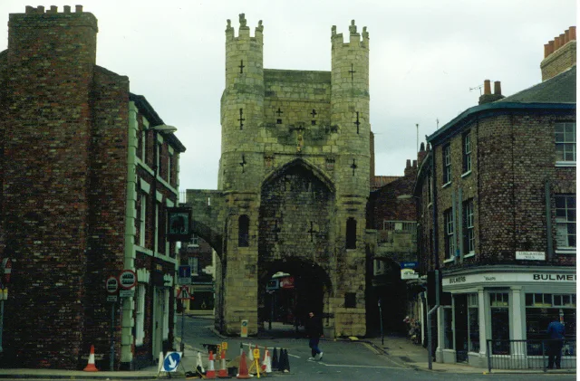
City Walls
City Walls is a historic bridge in the United Kingdom.

Wikimedia Commons contributors — see linked file page for photographer and licence licence
Plan your visit
- Typical visit
- 15 min–30 min
- Nearest railway station
- York · 1.1 km
- Free entry
- Dog-friendly
About
City Walls is a named historic bridge in the United Kingdom. Coordinates: 53.9628°, -1.0786°. This entry is part of The Great Britain Guide, a free, ad-free, open-data tourist directory.
Photo gallery
Heritage listing
View of the city, looking north-east from the city wall, near the railway station. The brown spire at left in the middle distance is the Oratory Church of Saint Wilfrid, and the three towers of York Minster are visible behind
From the Wikipedia article
York has, since Roman times, been defended by walls of one form or another. To this day, substantial portions of the walls remain, and York has more miles of intact wall than any other city in England. They are known variously as York City Walls, the Bar Walls and the Roman walls (though this last is a misnomer as very little of the extant stonework is of Roman origin, and the course of the wall has been substantially altered since Roman times). The walls are generally 13 feet (4 m) high and 6 feet (1.8 m) wide. They are the longest town walls in England.
Excerpt from Wikipedia under CC BY-SA 4.0. See the source article linked in Sources below.
Background
History
| mark-lat1= 53.96273 | mark-lon1= -1.08510 | mark-size1=10 | label1=Bootham Bar | label-size1=12 | label-color1=dark red | label-pos1=left | mark-title1=Bootham Bar | mark-image1= | mark-description1= | mark-lat2=53.96278 | mark-lon2=-1.07847 | label2=Monk Bar | label-pos2=bottom | mark-title2=Monk Bar | mark-image2= | mark-description2= | mark-lat3= 53.95520 | mark-lon3= -1.07077 | label3=Walmgate Bar | label-pos3=left | mark-title3=Walmgate Bar | mark-image3= | mark-description3= | mark-lat4=53.95586 | mark-lon4=-1.09084 | label4=Micklegate Bar | label-pos4=top | mark-title4=Micklegate Bar | mark-image4= | mark-description4= | mark-lat5=53.95397 | mark-lon5=-1.07524 | label5=Fishergate…
Sourced from Wikipedia under CC BY-SA 4.0.
- Coordinates
- 53.9628, -1.0786
- District
- York
- Parish
- York, unparished area
- Postcode
- YO31 7PD
- Parliamentary constituency
- York Central
- Phone
- +44 1904 624247
- Nearest railway station
- York — 1.1 km
- Official site
- www.york.gov.uk
Sources
- osm: w4474168 (ODbL)
- wikipedia: York city walls (CC BY-SA 4.0)
- commons: City walls attached to tower place.jpg (CC BY-SA 4.0)
Other places nearby
Loading nearby places…
Nearby
 📷 3
📷 3Museums · Yorkshire & the Humber
Richard III Experience at Monk Bar
Richard III Experience at Monk Bar — museum in the City of York, North Yorkshire, England.
📷 5Historic bridges · Yorkshire & the Humber
City Walls
City Walls is a historic bridge in the United Kingdom.
 📷 3
📷 3Historic houses · Yorkshire & the Humber
Cromwell House
Cromwell House — Grade II* listed building in York, North Yorkshire, England, UK.
 📷 3
📷 3Historic houses · Yorkshire & the Humber
The Dutch House
The Dutch House — Grade II* listed building In York, North Yorkshire, England, UK.
Hotels · Yorkshire & the Humber
DoubleTree by Hilton York
DoubleTree by Hilton York — a hotel in england yorkshire. 4-star. Brand: DoubleTree.
 📷 4
📷 4Public art & sculpture · Yorkshire & the Humber
Bile Beans
Bile Beans — a public art in england-yorkshire, United Kingdom.
More bridges in this region
.jpg?width=1200) 📷 3
📷 3Historic bridges · Yorkshire & the Humber
Aberford Bridge
Aberford Bridge is a historic bridge in the United Kingdom.
 📷 5
📷 5Historic bridges · Yorkshire & the Humber
Aldwark Bridge
Aldwark Bridge is a historic bridge in the United Kingdom.
 📷 3
📷 3Historic bridges · Yorkshire & the Humber
Anchor Bridge
Anchor Bridge is a historic bridge in the United Kingdom.
 📷 3
📷 3Historic bridges · Yorkshire & the Humber
Apperley Viaduct
Apperley Viaduct is a historic bridge in the United Kingdom.
Frequently asked questions
- Where is City Walls?
- City Walls is in Yorkshire, United Kingdom (postcode YO31 7PD), in the parish of York, unparished area.
- Who owns City Walls?
- City Walls is owned by City of York Council.
- Is City Walls free to visit?
- Yes, City Walls is free to enter.
- How do I get to City Walls?
- The nearest railway station is York, about 1.1 km away. Drivers can navigate to postcode YO31 7PD.