Mountains & hills · Scottish Highlands
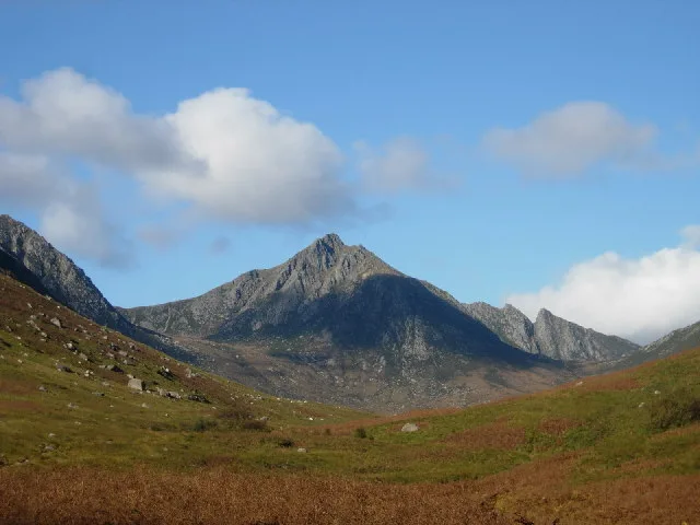
Cìr Mhòr
Also known as: A' Chìr Mhòr, Cir Mhor
Cìr Mhòr — Named summit at 799 m.

Wikimedia Commons contributors — see linked file page for photographer and licence licence
Plan your visit
- Typical visit
- 3 h–8 h
- Best time of year
- Late spring – early autumn (May–Oct)
- Free entry
- Dog-friendly
About
Cìr Mhòr is a named summit in the United Kingdom. Also known as: A' Chìr Mhòr. Wikidata describes it as: "Named summit at 799 m.". Coordinates: 55.6392°, -5.2224°.
Photo gallery
From the Wikipedia article
Cìr Mhòr (Scottish Gaelic, usually with definite article, A' Chìr Mhòr) is a Corbett known as the Matterhorn of Arran. Its name means the "big comb", referring its resemblance to a cockscomb. It is separated from the island's highest peak, Goat Fell, by a col called The Saddle.
Excerpt from Wikipedia under CC BY-SA 4.0. See the source article linked in Sources below.
- Coordinates
- 55.6392, -5.2224
- Address
- Isle of Arran, North Ayrshire, Scotland
Sources
- osm: n300806536 (ODbL)
- wikipedia: Cìr Mhòr (CC BY-SA 4.0)
- commons: Cir Mhor from Glen Rosa - geograph.org.uk - 77399.jpg (CC BY-SA 4.0)
Other places nearby
Loading nearby places…
Nearby
 📷 3
📷 3Natural landmarks · Scottish Highlands
Cìr Mhòr
Cìr Mhòr — mountain in North Ayrshire, Scotland, UK.
 📷 4
📷 4Viewpoints · Scottish Highlands
The Saddle
The Saddle is a viewpoint in the United Kingdom.
 📷 3
📷 3Mountains & hills · Scottish Highlands
A'Chir
A'Chir — a mountain in scotland-highlands, United Kingdom.
 📷 3
📷 3Mountains & hills · Scottish Highlands
Caisteal Abhail East Top
Caisteal Abhail East Top — a mountain in scotland-highlands, United Kingdom.
 📷 3
📷 3Mountains & hills · Scottish Highlands
Caisteal Abhail
Caisteal Abhail — Named summit at 859 m.
📷 3Mountains & hills · Scottish Highlands
Ceum na Caillich
Ceum na Caillich — a mountain in scotland-highlands, United Kingdom.
More mountains in this region
 📷 3
📷 3Mountains & hills · Scottish Highlands
A' Bhuidheanach Bheag
A' Bhuidheanach Bheag — Named summit at 936 m.
 📷 3
📷 3Mountains & hills · Scottish Highlands
A' Chailleach
A' Chailleach — Named summit at 997 m.
 📷 3
📷 3Mountains & hills · Scottish Highlands
A' Chailleach
A' Chailleach — Named summit at 930 m.
 📷 3
📷 3Mountains & hills · Scottish Highlands
A' Chaoirnich
A' Chaoirnich — Named summit at 875 m.
Frequently asked questions
- Where is Cìr Mhòr?
- Cìr Mhòr is in Scottish Highlands, in the United Kingdom — coordinates 55.6392°, -5.2224°.
- Is Cìr Mhòr free to visit?
- Yes — admission to Cìr Mhòr is free.