Natural landmarks · Scottish Highlands
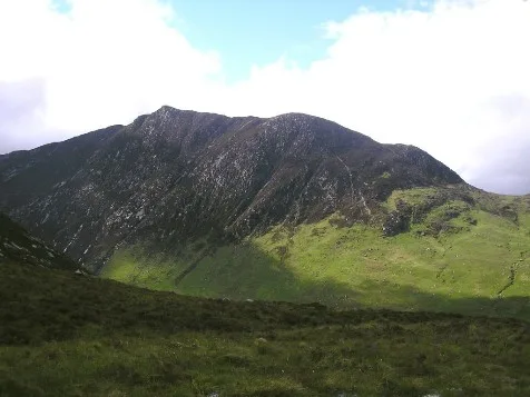
Caisteal Abhail
Caisteal Abhail — mountain on Arran, in North Ayrshire, Scotland, UK.

Wikimedia Commons contributors — see linked file page for photographer and licence licence
Plan your visit
- Typical visit
- 1 h–2 h
- Free entry
- Dog-friendly
About
Caisteal Abhail is a named natural landmark in the United Kingdom. Wikidata describes it as: "mountain on Arran, in North Ayrshire, Scotland, UK". Coordinates: 55.6506°, -5.2295°.
Photo gallery
From the Wikipedia article
Caisteal Abhail is a mountain on the Isle of Arran in Scotland. It is the northernmost Corbett on the island. The mountain forms the main part of a view known as The Sleeping Warrior due to its distinctive outline (resembling the profile of a recumbent figure) as seen from the mainland. The most notable feature of the mountain is Ceum na Caillich (often rendered as the "Witch's Step", cailleach, here in genitive also means an old woman/hag), a deep gash in the eastern ridge. It is the northernmost peak in a chain of three Corbetts. Goat Fell (the highest peak on Arran) is in fact an eastern outlier to this chain. The summit lies at the junction of four ridges: those running east, north and northwest eventually descend, whilst the southern ridge continues on to the central summit of the range, Cìr Mhòr. The summit is crowned with a series of rocky tors, and in poor visibility it may be difficult to ascertain which one marks the highest point. The mountain is most frequently climbed from North Glen Sannox. There is a car park on the A841 road two miles (three kilometres) west of Sannox. From here, the summit can be attained via the northern, northwestern or eastern ridge. Ascent over the eastern ridge requires the walker to negotiate Ceum na Caillich, a tricky scramble that is not easily bypassed. Ceum na Caillich and the eastern ridge may also be reached from the village of Sannox on the east coast of the island by way of Glen Sannox. The northwestern ridge can be climbed via a longer route following the Gleann Easan Biorach from Lochranza. An ascent of Caisteal Abhail is often combined with Cìr Mhòr, and indeed other Arran peaks. .
Excerpt from Wikipedia under CC BY-SA 4.0. See the source article linked in Sources below.
- Coordinates
- 55.6506, -5.2295
- Address
- Isle of Arran, North Ayrshire, Scotland
Sources
- wikidata: Q3356591 (CC0)
- wikipedia: Caisteal Abhail (CC BY-SA 4.0)
- commons: Caisteal abhail.jpg (CC BY-SA 4.0)
Other places nearby
Loading nearby places…
Nearby
 📷 3
📷 3Mountains & hills · Scottish Highlands
Caisteal Abhail
Caisteal Abhail — Named summit at 859 m.
 📷 3
📷 3Mountains & hills · Scottish Highlands
Caisteal Abhail East Top
Caisteal Abhail East Top — a mountain in scotland-highlands, United Kingdom.
📷 3Mountains & hills · Scottish Highlands
Ceum na Caillich
Ceum na Caillich — a mountain in scotland-highlands, United Kingdom.
 📷 3
📷 3Natural landmarks · Scottish Highlands
Cìr Mhòr
Cìr Mhòr — mountain in North Ayrshire, Scotland, UK.
 📷 3
📷 3Mountains & hills · Scottish Highlands
Cìr Mhòr
Cìr Mhòr — Named summit at 799 m.
 📷 4
📷 4Viewpoints · Scottish Highlands
The Saddle
The Saddle is a viewpoint in the United Kingdom.
More natural landmarks in this region
 Flagship📷 3
Natural landmarks · Scottish Highlands
Dunalastair Water
Dunalastair Water — lake in Perth and Kinross, Scotland, UK, on the River Tummel.
 Flagship📷 3
Natural landmarks · Scottish Highlands
Loch Arkaig
Loch Arkaig — lake in Highland, Scotland, UK, outflows east to River Arkaig.
 Flagship📷 3
Natural landmarks · Scottish Highlands
Loch Assynt
Loch Assynt — lake in Highland, Scotland, UK, outflows to the River Inver and Loch na Garbh Uidhe.
 Flagship📷 3
Natural landmarks · Scottish Highlands
Loch Awe
Loch Awe — lake in Argyll and Bute, Scotland, UK, outflows to the River Awe.
Frequently asked questions
- Where is Caisteal Abhail?
- Caisteal Abhail is in Scottish Highlands, in the United Kingdom — coordinates 55.6506°, -5.2295°.
- Is Caisteal Abhail free to visit?
- Yes — admission to Caisteal Abhail is free.