Towns & cities · London
Chesterton
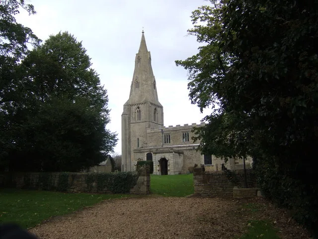
Chesterton — village in Huntingdonshire, Cambridgeshire, England, UK.

Wikimedia Commons contributors — see linked file page for photographer and licence licence
Plan your visit
- Typical visit
- 3 h–6 h
- Nearest railway station
- Overton for Ferry Meadows · 3.3 km
- Free entry
- Family-friendly
- Dog-friendly
About
Chesterton is a town, city, village or settlement in the United Kingdom. Recent population estimates put it at around 95 people. Address: PE7. Wikidata describes it as: "village in Huntingdonshire, Cambridgeshire, England, UK". Coordinates: 52.5400°, -0.3400°.
Photo gallery
From the Wikipedia article
Chesterton is a small village and civil parish of exactly 56 households in Cambridgeshire, England. The village lies approximately 5 miles (8 km) west-southwest of central Peterborough, near the city's Alwalton district. Chesterton is situated within Huntingdonshire which is a non-metropolitan district of Cambridgeshire as well as being a historic county of England. In the 17th century, Chesterton was the home of John Dryden's family, who lived in Chesterton manor. In the 1870s, Chesterton was described as "a parish in the district of Peterborough and county of Huntingdon; on the verge of the county, and on Ermine-street and the river Nen, 2½ miles SE of Castor r. station, and 5½ SW of Peterborough. Post town, Castor, under Peterborough. Acres, 1, 330. Real property, £2, 447. Pop., 129. Houses, 22."
Excerpt from Wikipedia under CC BY-SA 4.0. See the source article linked in Sources below.
Background
History
Chesterton is rich in Roman history, with the name Chesterton meaning "Roman site farm/settlement". MR A. Guest presents the Romans appearance as impressive, when he states "The Roman colonisation of the parish was impressive. Their first appearance was military, a five acre fort at Water Newton on the North border of Chesterton, which was built in the mid first century to guard the crossing of the Nene. A Civil settlement soon appeared at the gates of the fort, this became Chesterton with its North and West boundary being the River Nene and Billings Brook respectively. Durobrivae was contained within this boundary, with a Roman Signal Station at its highest point near its Southern border."…
Sourced from Wikipedia under CC BY-SA 4.0.
- Coordinates
- 52.5400, -0.3400
- County
- Cambridgeshire
- District
- Huntingdonshire
- Parish
- Chesterton
- Postcode
- PE7
- Parliamentary constituency
- North West Cambridgeshire
- Population
- 95
- Nearest railway station
- Overton for Ferry Meadows — 3.3 km
Sources
- wikidata: Q955904 (CC0)
- wikipedia: Chesterton, Huntingdonshire (CC BY-SA 4.0)
- commons: The Church of St Michael Chesterton - geograph.org.uk - 265404.jpg (CC BY-SA 4.0)
Other places nearby
Loading nearby places…
Nearby
 📷 5
📷 5Historic churches · London
Parish Church of St Michael
Parish Church of St Michael — Grade I listed church in Huntingdonshire, United Kingdom.
.jpg?width=1200) 📷 5
📷 5Historic houses · London
The Manor House
The Manor House — house in Alwalton, Huntingdonshire, England, UK.
 📷 5
📷 5Manor houses · London
Alwalton Manor
Alwalton Manor — a manor in england-london, United Kingdom.
 📷 5
📷 5Windmills · London
Wind Mill About 150 Yds South East Of Castor Mill
Wind Mill About 150 Yds South East Of Castor Mill — Grade II listed building-listed windmill in england-london, United Kingdom.
.jpg?width=1200) 📷 5
📷 5Mills · London
Castor Mill
Castor Mill — mill in Castor, Peterborough, Cambridgeshire, England, UK.
 📷 5
📷 5Archaeological sites · London
Durobrivae, Roman Town
Durobrivae, Roman Town — a archaeological in england-london, United Kingdom.
More towns in this region
 Flagship📷 10
Towns & cities · London
Aldenham
Aldenham — village and civil parish in Hertfordshire, England.
 Flagship📷 10
Towns & cities · London
Ashdon
Ashdon — village and civil parish in Essex, UK.
 Flagship📷 10
Towns & cities · London
Betchworth
Betchworth — village and civil parish in the Mole Valley district of Surrey, England.
 Flagship📷 10
Towns & cities · London
Boxley
Boxley — village and civil parish in Maidstone District, Kent, England, UK.
Frequently asked questions
- Where is Chesterton?
- Chesterton is in Cambridgeshire, London, United Kingdom (postcode PE7), in the parish of Chesterton.
- Is Chesterton free to visit?
- Yes, Chesterton is free to enter.
- How do I get to Chesterton?
- The nearest railway station is Overton for Ferry Meadows, about 3.3 km away. Drivers can navigate to postcode PE7.