Museums · Yorkshire & the Humber
Castleford
Castleford is a town within the City of Wakefield district, West Yorkshire, England. It had a population of 45,106 at a 2021 population estimate. Historically in the West Riding of Yorkshire, to the n

Darren Haddock — CC BY-SA 2.0 via Wikimedia Commons licence
Plan your visit
- Typical visit
- 1.5 h–3 h
- Best time of year
- Year-round
- Family-friendly
- Limited wheelchair access
About
Castleford is a town within the City of Wakefield district, West Yorkshire, England. It had a population of 45,106 at a 2021 population estimate. Historically in the West Riding of Yorkshire, to the north of the town centre the River Calder joins the River Aire and the Aire and Calder Navigation. It is located north east of Wakefield, north of Pontefract and south east of Leeds. Castleford is the largest town in the Wakefield district after Wakefield itself. The town is the site of a Roman settlement. Within the historical Municipal Borough of Castleford are the suburbs of Airedale, Cutsyke, Ferry Fryston, Fryston Village, Glasshoughton, Half Acres, Hightown, Lock Lane, Townville, Wheldale and Whitwood. Castleford is home to the rugby league Super League team Castleford Tigers.
Photo gallery
From the Wikipedia article
Castleford is a town within the City of Wakefield district, West Yorkshire, England. It had a population of 45,106 at a 2021 population estimate. Historically in the West Riding of Yorkshire, to the north of the town centre the River Calder joins the River Aire and the Aire and Calder Navigation. It is located north east of Wakefield, north of Pontefract and south east of Leeds. Castleford is the largest town in the Wakefield district after Wakefield itself. The town is the site of a Roman settlement. Within the historical Municipal Borough of Castleford are the suburbs of Airedale, Cutsyke, Ferry Fryston, Fryston Village, Glasshoughton, Half Acres, Hightown, Lock Lane, Townville, Wheldale and Whitwood. Castleford is home to the rugby league Super League team Castleford Tigers.
Excerpt from Wikipedia under CC BY-SA 4.0. See the source article linked in Sources below.
Background
History
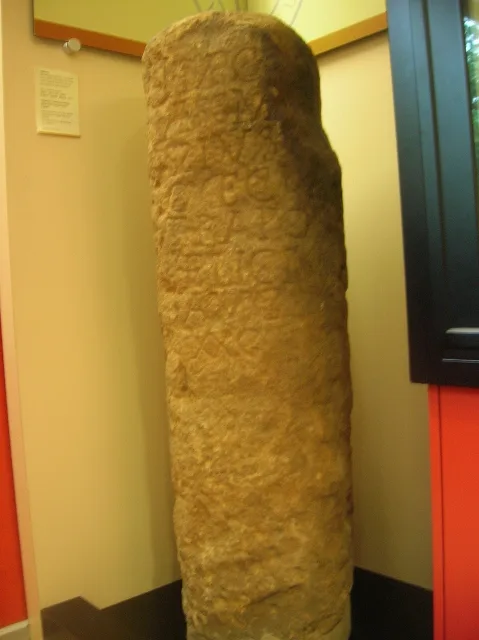
Castleford's history dates back to Roman times, archaeological evidence points to modern day Castleford being built upon a Roman army settlement which was called Lagentium (thought to mean 'The Place of the Swordsmen'). Roman funeral urns have been found in modern-day Castleford, giving further evidence to this theory. A Roman milestone was unearthed in Beancroft Road, now believed to be in Leeds City Museum. Queen's Park in Castleford provides evidence of Roundhouses used by the Anglo Saxons. This was a strategic area due to the views of the entire settlement. The history of the area includes Oliver Cromwell's encampment in nearby Knottingley and Ferrybridge (originally thought to be in…
Sourced from Wikipedia under CC BY-SA 4.0.
- Coordinates
- 53.7160, -1.3560
- District
- Wakefield
- Parish
- Wakefield, unparished area
- Postcode
- WF10 5SE
- Parliamentary constituency
- Pontefract, Castleford and Knottingley
Sources
- wikipedia: Castleford (CC BY-SA 4.0)
Other places nearby
Loading nearby places…
Nearby
 📷 3
📷 3Memorials & monuments · Yorkshire & the Humber
Glasshoughton Wheel of Light
Glasshoughton Wheel of Light — a memorial in england-yorkshire, United Kingdom.
 📷 3
📷 3Escape rooms · Yorkshire & the Humber
Escapologist
Escapologist — a escape room in england-yorkshire, United Kingdom.
 📷 3
📷 3Historic bridges · Yorkshire & the Humber
Tickle Cock Bridge
Tickle Cock Bridge is a historic bridge in the United Kingdom.
 📷 3
📷 3Theatres · Yorkshire & the Humber
Albion Cinema
Albion Cinema in England Yorkshire, United Kingdom.
📷 5Theatres · Yorkshire & the Humber
Cannon Castleford
Cannon Castleford — a cinema heritage in england-yorkshire, United Kingdom.
 📷 3
📷 3Trampoline parks · Yorkshire & the Humber
Gravity Trampoline Park
Gravity Trampoline Park — a trampoline park in england-yorkshire, United Kingdom.
More museums in this region
 📷 3
📷 3Museums · Yorkshire & the Humber
Aldborough Roman Town
Aldborough Roman Town — Heritage Museum in Yorkshire, England, UK.
 📷 3
📷 3Museums · Yorkshire & the Humber
Bayle Museum
Bayle Museum — Local museum in Bridlington, England.
Museums · Yorkshire & the Humber
BD1 Gallery
BD1 Gallery — closed gallery in Bradford, West Yorkshire.
 📷 5
📷 5Museums · Yorkshire & the Humber
Beck Isle Museum
Beck Isle Museum — museum in Pickering, North Yorkshire, England, United Kingdom.
Frequently asked questions
- Where is Castleford?
- Castleford is in Yorkshire & the Humber, in the United Kingdom — coordinates 53.7160°, -1.3560°.
- Is Castleford wheelchair accessible?
- Partially — OpenStreetMap notes limited wheelchair access at Castleford. Check ahead for specific facilities.