Museums · Yorkshire & the Humber
City of Wakefield
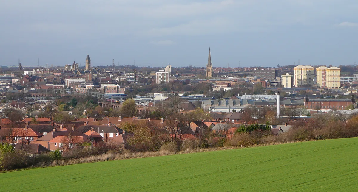
Wakefield, also known as the City of Wakefield, is a local government district with city status and a metropolitan district in West Yorkshire, England. Wakefield, the largest settlement, is the admini

habiloid — CC BY-SA 2.0 via Wikimedia Commons licence
Plan your visit
- Typical visit
- 1.5 h–3 h
- Best time of year
- Year-round
- Family-friendly
- Limited wheelchair access
About
Wakefield, also known as the City of Wakefield, is a local government district with city status and a metropolitan district in West Yorkshire, England. Wakefield, the largest settlement, is the administrative centre of the district. The population of the City of Wakefield at the 2011 Census was 325,837. The district includes the Five Towns of Castleford, Featherstone, Knottingley, Normanton and Pontefract. Other towns include Hemsworth, Horbury, Ossett, South Elmsall and South Kirkby (also forms the civil parish of South Kirkby and Moorthorpe). The city and district are governed by Wakefield Council from the County Hall. In 2010, Wakefield was named as the UK's third most musical city by PRS for Music.
Photo gallery
From the Wikipedia article
Wakefield, also known as the City of Wakefield, is a local government district with city status and a metropolitan district in West Yorkshire, England. Wakefield, the largest settlement, is the administrative centre of the district. The population of the City of Wakefield at the 2011 Census was 325,837. The district includes the Five Towns of Castleford, Featherstone, Knottingley, Normanton and Pontefract. Other towns include Hemsworth, Horbury, Ossett, South Elmsall and South Kirkby (also forms the civil parish of South Kirkby and Moorthorpe). The city and district are governed by Wakefield Council from the County Hall. In 2010, Wakefield was named as the UK's third most musical city by PRS for Music.
Excerpt from Wikipedia under CC BY-SA 4.0. See the source article linked in Sources below.
Background
History
The former Borough of Wakefield was raised to city status by letters patent in 1888. It became a county borough in 1913, taking it out of the jurisdiction of the West Riding County Council. The present boundaries were set in 1974 by the Local Government Act 1972, when the County Borough of Wakefield merged with the West Riding municipal boroughs of Castleford, Ossett and Pontefract, the urban districts of Featherstone, Hemsworth, Horbury, Knottingley, Normanton and Stanley, along with Wakefield Rural District and parts of Hemsworth Rural District and Osgoldcross Rural District. The new metropolitan district's city status was reconfirmed by letters patent in 1974. The Council's headquarters…
Sourced from Wikipedia under CC BY-SA 4.0.
- Coordinates
- 53.6830, -1.4990
- District
- Wakefield
- Parish
- Wakefield, unparished area
- Postcode
- WF1 1PA
- Parliamentary constituency
- Wakefield and Rothwell
- Official site
- www.theatreroyalwakefield.co.uk
Sources
- wikipedia: City of Wakefield (CC BY-SA 4.0)
Other places nearby
Loading nearby places…
Nearby
 Flagship📷 5
Towns & cities · Yorkshire & the Humber
Wakefield
Wakefield — city in West Yorkshire, England.
 📷 4
📷 4Cathedrals · Yorkshire & the Humber
Wakefield Cathedral
Wakefield Cathedral — a Grade I-listed cathedral in england-yorkshire, United Kingdom.
 📷 4
📷 4Gardens · Yorkshire & the Humber
Wakefield Exchange
Wakefield Exchange — a garden in england-yorkshire, United Kingdom.
 📷 3
📷 3Public art & sculpture · Yorkshire & the Humber
Trinity Walk Sculptural Column
Trinity Walk Sculptural Column — a public art in england-yorkshire, United Kingdom.
Hotels · Yorkshire & the Humber
Bank House Hotel
Bank House Hotel — a hotel in england yorkshire.
 📷 3
📷 3Historic houses · Yorkshire & the Humber
Crown Court House
Crown Court House — house in Wakefield, West Yorkshire, England, UK.
More museums in this region
 📷 3
📷 3Museums · Yorkshire & the Humber
Aldborough Roman Town
Aldborough Roman Town — Heritage Museum in Yorkshire, England, UK.
 📷 3
📷 3Museums · Yorkshire & the Humber
Bayle Museum
Bayle Museum — Local museum in Bridlington, England.
Museums · Yorkshire & the Humber
BD1 Gallery
BD1 Gallery — closed gallery in Bradford, West Yorkshire.
 📷 5
📷 5Museums · Yorkshire & the Humber
Beck Isle Museum
Beck Isle Museum — museum in Pickering, North Yorkshire, England, United Kingdom.
Frequently asked questions
- Where is City of Wakefield?
- City of Wakefield is in Yorkshire & the Humber, in the United Kingdom — coordinates 53.6830°, -1.4990°.
- Is City of Wakefield wheelchair accessible?
- Partially — OpenStreetMap notes limited wheelchair access at City of Wakefield. Check ahead for specific facilities.