Viewpoints · South West England
Cape Cornwall
Also known as: Kilgoodh, Kylgoodh Ust
Cape Cornwall — Named viewpoint at 199 m elevation.

Ian Capper — CC BY-SA 2.0 via Wikimedia Commons licence
Plan your visit
- Typical visit
- 20 min–45 min
- Best time of year
- Clear days year-round
- Free entry
- Dog-friendly
About
Cape Cornwall is a named viewpoint in South-West England, marked on Ordnance Survey maps for its outlook. The site is within the Cornwall National Landscape (AONB), and is a designated Site of Special Scientific Interest. It sits within the St Ives parliamentary constituency. Postcode area TR19.
Photo gallery
Protected designations
- Site of Special Scientific Interest: Aire Point to Carrick Du SSSI
- Area of Outstanding Natural Beauty: Cornwall
Designations sourced from Natural England open data under OGL v3.
From the Wikipedia article
Cape Cornwall (Cornish: Kilgoodh, meaning "goose back") is a small headland in West Cornwall, England. It is 4 miles (6.4 km) north of Land's End near the town of St Just. Until the first Ordnance Survey in the early 19th-century, Cape Cornwall was believed to be the most westerly point in Cornwall. Most of the headland is owned by the National Trust. National Coastwatch has a look-out on the seaward side. The only tourist infrastructure at present is a car park (owned by the National Trust), public toilets, and a refreshments counter during the summer. The Brisons, two offshore rocks, are located approximately 1 mile (1.6 km) southwest of Cape Cornwall. They mark the starting line of the annual swimming race ending at Priest Cove.
Excerpt from Wikipedia under CC BY-SA 4.0. See the source article linked in Sources below.
Background
History
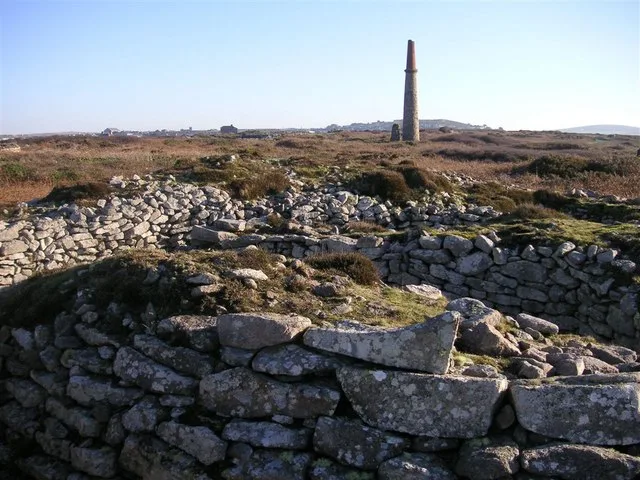
visible in the centre) commemorates the purchase of Cape Cornwall for the nation by H. J. Heinz Company. The ruins of St. Helen's Oratory can be seen on the left, with the two offshore rocks called The Brisons in the distance.]] Pottery found in cists on the Cape have been dated to the Late Bronze Age. The presence of another cliff castle nearby (Kenidjack) may indicate that the area was important in the Iron Age. On the landward side of the Cape is the remains of the medieval St Helen's Oratory, which replaced a 6th-century church. A font now installed in the porch of St Just church may be from this building.
Sourced from Wikipedia under CC BY-SA 4.0.
- Coordinates
- 50.1272, -5.7088
- District
- Cornwall
- Parish
- St. Just
- Postcode
- TR19 7NN
- Parliamentary constituency
- St Ives
- Official site
- en.wikipedia.org
Sources
- osm: n602822636 (ODbL)
- wikipedia: Cape Cornwall (CC BY-SA 4.0)
Other places nearby
Loading nearby places…
Nearby
📷 3Historic houses · South West England
Cape Cornwall Chimney
Cape Cornwall Chimney — a historic house in england-south-west, United Kingdom.
 📷 5
📷 5Chapels · South West England
Medieval chapel called St Helen's Chapel with a dwelling and enclosure at Cape Cornwall
Medieval chapel called St Helen's Chapel with a dwelling and enclosure at Cape Cornwall — chapel in St Just, Cornwall, England, UK.
 📷 3
📷 3Historic houses · South West England
St. Helen's Oratory
St. Helen's Oratory — a historic house in england-south-west, United Kingdom.
 📷 3
📷 3Historic houses · South West England
St Just Amalgamated Mine Shaft
St Just Amalgamated Mine Shaft — a historic house in england-south-west, United Kingdom.
 📷 5
📷 5Hill forts · South West England
Ballowall Barrow
Ballowall Barrow — archaeological site in St Just, Cornwall, England, UK.
 📷 3
📷 3Castles · South West England
Wheal Castle (Boswedden Mine)
Wheal Castle (Boswedden Mine) — a castle in england-south-west, United Kingdom.
More viewpoints in this region
 📷 5
📷 5Viewpoints · South West England
199
199 — Named viewpoint at 69.099976 m elevation.
 📷 5
📷 5Viewpoints · South West England
Artists Chair
Artists Chair is a viewpoint in the United Kingdom.
 📷 5
📷 5Viewpoints · South West England
Bass Point
Bass Point is a viewpoint in the United Kingdom.
 📷 5
📷 5Viewpoints · South West England
Beacon
Beacon is a viewpoint in the United Kingdom.
Frequently asked questions
- Where is Cape Cornwall?
- Cape Cornwall is in South-West England, United Kingdom (postcode TR19 7NN), in the parish of St. Just.
- Is Cape Cornwall a protected site?
- Yes — Cape Cornwall is part of the Aire Point to Carrick Du SSSI Site of Special Scientific Interest and the Cornwall National Landscape (AONB).
- Is Cape Cornwall free to visit?
- Yes, Cape Cornwall is free to enter.
- How do I get to Cape Cornwall?
- Drivers can navigate to postcode TR19 7NN. It sits within the St Ives parliamentary constituency.