Natural landmarks · Scottish Highlands
Cairn Toul
Also known as: Càrn an t-Sabhail
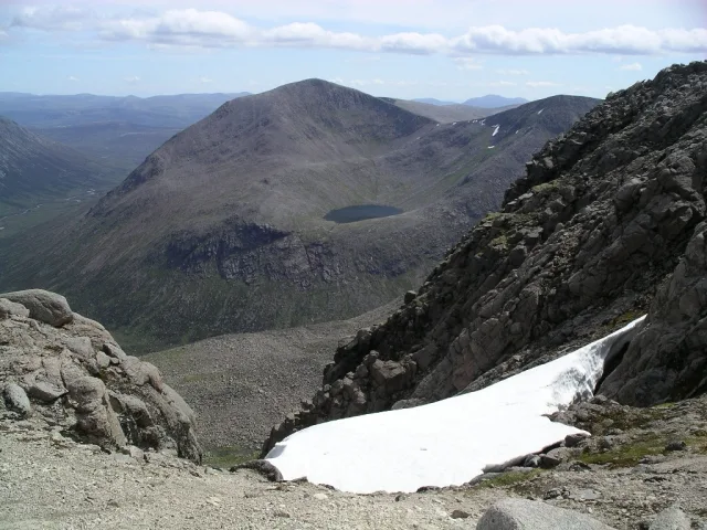
Cairn Toul — 1291m high mountain in Aberdeenshire, Scotland, UK.

Wikimedia Commons contributors — see linked file page for photographer and licence licence
Plan your visit
- Typical visit
- 1 h–2 h
- Nearest railway station
- Sheiling / Middle · 8.7 km
- Free entry
- Dog-friendly
About
Cairn Toul is a named natural landmark in the United Kingdom. Wikidata describes it as: "1291m high mountain in Aberdeenshire, Scotland, UK". Coordinates: 57.0544°, -3.7108°.
Photo gallery
From the Wikipedia article
Cairn Toul (Scottish Gaelic: Càrn an t-Sabhail, 'hill of the barn') is the 4th-highest mountain in Scotland and all of the British Isles, after Ben Nevis, Ben Macdui and Braeriach. The summit is 1,291 metres (4,236 feet) above sea level. It is in the western massif of the Cairngorms, linked by a bealach at about 1125 m to Braeriach. The mountain towers above the Lairig Ghru pass. Cairn Toul is often climbed together with other peaks. From the south, it may be climbed with The Devil's Point, which lies about 2.5 kilometres south-southeast. Alternatively, it may be climbed from the north, including Braeriach and Sgor an Lochain Uaine. Both routes are long days by Scottish standards: around 15 km (plus return) regardless of whether one starts from Coire Cas above Speyside, or Linn of Dee to the south. The mountain may also be climbed from the west, starting from Achlean in Glen Feshie. This provides for a slighter shorter route (around 27 km for the round trip), though the walker must negotiate a large expanse of undulating boggy plateau in order to reach the Braeriach-Cairn Toul massif. There is a bothy, Corrour, at the point below Cairn Toul in the defile of the Lairig Ghru.
Excerpt from Wikipedia under CC BY-SA 4.0. See the source article linked in Sources below.
- Coordinates
- 57.0544, -3.7108
- Address
- Cairngorms, Scotland
- Nearest railway station
- Sheiling / Middle — 8.7 km
- Official site
- www.hill-bagging.co.uk
Sources
- wikidata: Q1025930 (CC0)
- wikipedia: Cairn Toul (CC BY-SA 4.0)
- commons: Cairn toul.jpg (CC BY-SA 4.0)
Other places nearby
Loading nearby places…
Nearby
 📷 3
📷 3Mountains & hills · Scottish Highlands
Cairn Toul
Cairn Toul — Named summit at 1291 m.
 📷 3
📷 3Mountains & hills · Scottish Highlands
Stob Coire an t-Saighdeir
Stob Coire an t-Saighdeir — a mountain in scotland-highlands, United Kingdom.
 📷 3
📷 3Mountains & hills · Scottish Highlands
Sgor an Lochain Uaine
Sgor an Lochain Uaine — Named summit at 1258 m.
 📷 3
📷 3Natural landmarks · Scottish Highlands
Sgòr an Lochain Uaine
Sgòr an Lochain Uaine — 1258m high mountain in Aberdeenshire, Scotland, UK.
 📷 3
📷 3Natural landmarks · Scottish Highlands
The Devil's Point
The Devil's Point — 1004m high mountain in Aberdeenshire, Scotland, UK.
 📷 3
📷 3Mountains & hills · Scottish Highlands
The Devil's Point
The Devil's Point — Named summit at 1004 m.
More natural landmarks in this region
 Flagship📷 3
Natural landmarks · Scottish Highlands
Dunalastair Water
Dunalastair Water — lake in Perth and Kinross, Scotland, UK, on the River Tummel.
 Flagship📷 3
Natural landmarks · Scottish Highlands
Loch Arkaig
Loch Arkaig — lake in Highland, Scotland, UK, outflows east to River Arkaig.
 Flagship📷 3
Natural landmarks · Scottish Highlands
Loch Assynt
Loch Assynt — lake in Highland, Scotland, UK, outflows to the River Inver and Loch na Garbh Uidhe.
 Flagship📷 3
Natural landmarks · Scottish Highlands
Loch Awe
Loch Awe — lake in Argyll and Bute, Scotland, UK, outflows to the River Awe.
Frequently asked questions
- Where is Cairn Toul?
- Cairn Toul is in Scottish Highlands, in the United Kingdom — coordinates 57.0544°, -3.7108°. The nearest railway station is Sheiling / Middle, around 8.7 km away.
- Is Cairn Toul free to visit?
- Yes — admission to Cairn Toul is free.