Mountains & hills · Central Scotland
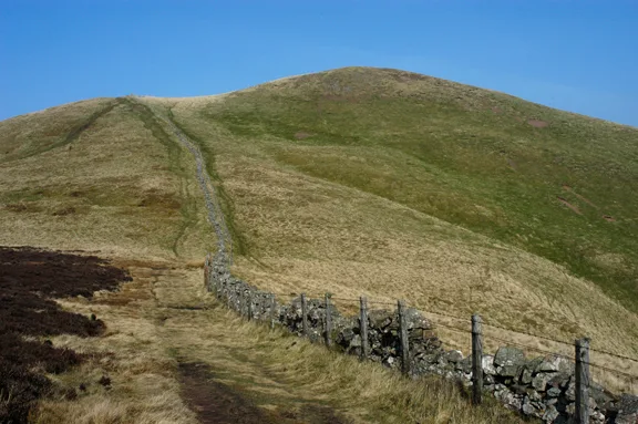
Caerketton Hill
Caerketton Hill — Named summit at 478 m.

Wikimedia Commons contributors — see linked file page for photographer and licence licence
Plan your visit
- Typical visit
- 3 h–8 h
- Best time of year
- Late spring – early autumn (May–Oct)
- Nearest railway station
- Kingsknowe · 4.8 km
- Free entry
- Dog-friendly
About
Caerketton Hill is a named summit in the United Kingdom. Wikidata describes it as: "Named summit at 478 m.". Coordinates: 55.8831°, -3.2214°.
Photo gallery
From the Wikipedia article
Caerketton Hill ( kər-KET-ən) is a hill in the Pentland Hills range of Scotland. Standing at 478 m, it is at the northeast end of the approximately 25 km (16 mi) long chain of hills on the border between the council areas of the City of Edinburgh and Midlothian. The nearest town is Loanhead, 2 kilometers to the east while Edinburgh's southern suburbs start about a kilometer to the north. The nearest hills are Allermuir Hill to the west and Woodhouselee Hill to the south. The Swanston Burn and Lothian Burn rise on the northern slopes while the Boghall Burn receives water from the southern slopes. Their waters meet in the Burdiehouse Burn and, eventually, as the Brunstane Burn, drain into the Firth of Forth at Eastfield, Edinburgh. On the crest of the hill are the scattered remains of a cairn now consisting of small stones, 16 meters in diameter and 1.5 meter high. The cairn is protected as a scheduled monument.
Excerpt from Wikipedia under CC BY-SA 4.0. See the source article linked in Sources below.
- Coordinates
- 55.8831, -3.2214
- District
- City of Edinburgh
- Postcode
- EH10 7DT
- Parliamentary constituency
- Edinburgh South West
- Nearest railway station
- Kingsknowe — 4.8 km
Sources
- osm: n363606217 (ODbL)
- wikipedia: Caerketton Hill (CC BY-SA 4.0)
- commons: Pentland Nursery - geograph.org.uk - 947430.jpg (CC BY-SA 4.0)
Other places nearby
Loading nearby places…
Nearby
Vineyards · Central Scotland
Caerketton hillfort
Caerketton hillfort — a UK vineyard in scotland central, producing English or Welsh wine from cool-climate grape varieties.
 📷 3
📷 3Mountains & hills · Central Scotland
Allermuir Hill
Allermuir Hill — Named summit at 493 m.
Vineyards · Central Scotland
Woodhouselee Hill
Woodhouselee Hill — a UK vineyard in scotland central, producing English or Welsh wine from cool-climate grape varieties.
Mountain bike trails · Central Scotland
Dreghorn-Castlelaw
Dreghorn-Castlelaw — a mtb trail in scotland central.
Vineyards · Central Scotland
Torgeith Knowe
Torgeith Knowe — a UK vineyard in scotland central, producing English or Welsh wine from cool-climate grape varieties.
 📷 3
📷 3Memorials & monuments · Central Scotland
Fraser Tytler Memorial
Fraser Tytler Memorial — a memorial in scotland-central, United Kingdom.
More mountains in this region
 📷 3
📷 3Mountains & hills · Central Scotland
Abbey Hill
Abbey Hill — Named summit at 278 m.
 📷 3
📷 3Mountains & hills · Central Scotland
Aberlady Bay
Aberlady Bay — bay on the north coast of East Lothian, Scotland, UK.
📷 3Mountains & hills · Central Scotland
Allermuir Hill
Allermuir Hill — Named summit at 493 m.
 📷 3
📷 3Mountains & hills · Central Scotland
Ardnandave
Ardnandave — Named summit at 715 m.
Frequently asked questions
- Where is Caerketton Hill?
- Caerketton Hill is in central Scotland, United Kingdom (postcode EH10 7DT).
- Is Caerketton Hill free to visit?
- Yes, Caerketton Hill is free to enter.
- How do I get to Caerketton Hill?
- The nearest railway station is Kingsknowe, about 4.8 km away. Drivers can navigate to postcode EH10 7DT.