Mountains & hills · South East England
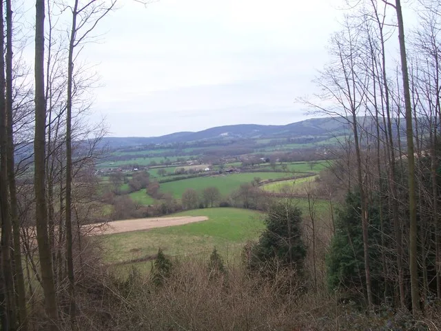
Butser Hill
Butser Hill — Named summit at 270 m.

Wikimedia Commons contributors — see linked file page for photographer and licence licence
Plan your visit
- Typical visit
- 3 h–8 h
- Best time of year
- Late spring – early autumn (May–Oct)
- Nearest railway station
- Petersfield · 4.2 km
- Free entry
- Dog-friendly
About
Butser Hill is a named summit in the United Kingdom. Wikidata describes it as: "Named summit at 270 m.". Coordinates: 50.9780°, -0.9806°.
Photo gallery
Protected designations
- Site of Special Scientific Interest: Butser Hill SSSI
- National Nature Reserve: BUTSER HILL
Designations sourced from Natural England open data under OGL v3.
From the Wikipedia article
Butser Hill is a hill and nature reserve in Hampshire, England. South-west of Petersfield, it is a 239.7-hectare (592-acre) biological and geological Site of Special Scientific Interest. It is a National Nature Reserve and a Special Area of Conservation. Part of it is a Geological Conservation Review site and an area of 84.8 hectares (210 acres), Oxenbourne Down, is designated a Local Nature Reserve. Part of it is a Scheduled Monument. It is a chalk hill and one of the highest points in Hampshire. It is also the highest point on the chalk ridge of the South Downs and the second-highest point in the South Downs National Park after Blackdown in the Western Weald. Although only 271 metres (889 ft) high, it qualifies as one of England's Marilyns. It is located within the borders of the Queen Elizabeth Country Park. The name Butser comes from the Old English Bryttes Oran meaning "Briht's slope". Oran or Ora is Old English for a flat-topped hill and/or steep slope. The flat summit is surrounded by a number of spurs. Iron Age ditches and banks divide the spurs from the summit although the purpose of these earthworks is unclear. There is evidence of lynchet farming on the southeast side of the hill. The age of the lynchets is unknown but Roman pottery has been brought to the surface by rabbit holes. There are aerial masts on the hill. The hill was purchased by Hampshire County Council in 1966. Before the purchase the summit was used for growing wheat, but now the only farming activity is grazing. In December 2021 a £240,000 program was announced to restore grassland on the hill and improve trails. Butser Hill has a rich variety of flora and fauna. It is an important area for butterfly conservation, with more than 30 species of butterfly recorded including populations of Duke of Burgundy and the Silver-spotted Skipper. An annual Fell Run called the Butser Hill Challenge involves running up and down the hill three times.
Excerpt from Wikipedia under CC BY-SA 4.0. See the source article linked in Sources below.
- Coordinates
- 50.9780, -0.9806
- County
- Hampshire
- District
- East Hampshire
- Parish
- Buriton
- Postcode
- GU31 5SP
- Parliamentary constituency
- East Hampshire
- Nearest railway station
- Petersfield — 4.2 km
Sources
- osm: n29267161 (ODbL)
- wikipedia: Butser Hill (CC BY-SA 4.0)
- commons: Butser Hill.jpg (CC BY-SA 4.0)
Other places nearby
Loading nearby places…
Nearby
Vineyards · South East England
Butser Hill
Butser Hill — a UK vineyard in england south east, producing English or Welsh wine from cool-climate grape varieties.
 📷 5
📷 5Memorials & monuments · South East England
Cross Dykes
Cross Dykes — a memorial in england-south-east, United Kingdom.
📷 5Archaeological sites · South East England
Pillow Mound
Pillow Mound — a archaeological in england-south-east, United Kingdom.
Mountain bike trails · South East England
Shipwright's Way
Shipwright's Way — a mtb trail in england south east.
 📷 5
📷 5Mountains & hills · South East England
War Down
War Down — Named summit at 244 m.
Mountain bike trails · South East England
QECP Red MTB
QECP Red MTB — a mtb trail in england south east.
More mountains in this region
 📷 5
📷 5Mountains & hills · South East England
Alum Bay
Alum Bay is a mountain or hill in the United Kingdom.
 📷 5
📷 5Mountains & hills · South East England
Arish Mell
Arish Mell — bay in Dorset, England.
 📷 5
📷 5Mountains & hills · South East England
Balaclava Bay
Balaclava Bay — bay in Dorset, England.
 📷 5
📷 5Mountains & hills · South East England
Balch Cave
Balch Cave — Cave in Somerset, England.
Frequently asked questions
- Where is Butser Hill?
- Butser Hill is in Hampshire, South-East England, United Kingdom (postcode GU31 5SP), in the parish of Buriton.
- Is Butser Hill a protected site?
- Yes — Butser Hill is part of the Butser Hill SSSI Site of Special Scientific Interest and the BUTSER HILL National Nature Reserve.
- Is Butser Hill free to visit?
- Yes, Butser Hill is free to enter.
- How do I get to Butser Hill?
- The nearest railway station is Petersfield, about 4.2 km away. Drivers can navigate to postcode GU31 5SP.