Historic bridges · Scottish Lowlands
Bridge 450 Metres South East Of Nunwick Hall
Bridge 450 Metres South East Of Nunwick Hall — Grade II listed building-listed bridge in scotland-lowlands, United Kingdom.

Paul Beaman — CC BY-SA 2.0 via Wikimedia Commons licence
Plan your visit
- Typical visit
- 15 min–30 min
- Free entry
- Dog-friendly
About
Bridge 450 Metres South East Of Nunwick Hall is a Grade II listed building-listed bridge in scotland-lowlands, United Kingdom, registered on the National Heritage List for England (NHLE entry 1370330). Listed status protects buildings and structures of special architectural or historic interest. See the linked Wikipedia article for further details.
Photo gallery
Heritage listing
Details SIMONBURN B 6320, Nunwick NY 87 SE 883739 (East side, off) 9/127 Bridge, 450 metres south-east of Nunwick Hall II Bridge. Early C19. Tooled dressed sandstone. Both faces identical. Wide elliptical arch under moulded band. Parapet above road-level band has projecting chamfered coping, splayed ends and is raked to either side of apex. Taller, projecting rectangular-plan end piers with bands and chamfered caps. An important landscape feature in Nunwick Park. Listing NGR: NY8837673957 Legacy The contents of this record have been generated from a legacy data system. Legacy System number: 240811 Legacy System: LBS
From the Historic England List Entry under OGL v3.
Place summary
Bridge 450 Metres South East Of Nunwick Hall is a Grade II listed bridge located in the Scottish Lowlands, within the parish of Simonburn. Its designation reflects its architectural and historical significance in the region.
AI-generated from the structured facts on this page (operator, designation, listing, era). Not a substitute for visiting.
- Coordinates
- 55.0600, -2.1835
- District
- Northumberland
- Parish
- Simonburn
- Postcode
- NE48 3AG
- Parliamentary constituency
- Hexham
Sources
- wikidata: Q26651571 (CC0)
Other places nearby
Loading nearby places…
Nearby
 📷 3
📷 3Historic houses · North East England
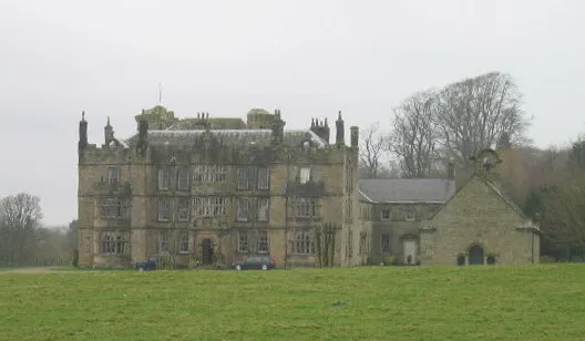
Nunwick Hall
Nunwick Hall in England North East, United Kingdom.
 📷 5
📷 5Other places · North East England
Simonburn
Simonburn in England North East, United Kingdom.
📷 3Historic bridges · Scottish Lowlands
Simonburn Bridge
Simonburn Bridge — Grade II listed building-listed bridge in scotland-lowlands, United Kingdom.
📷 3Memorials & monuments · Scottish Lowlands
Simonburn War Memorial, Village Green
Simonburn War Memorial, Village Green — Grade II listed building-listed memorial in scotland-lowlands, United Kingdom.
 📷 3
📷 3Chapels · Scottish Lowlands
Chapel At Chipchase Castle
Chapel At Chipchase Castle — Grade I listed chapel in Chollerton, Northumberland, England, UK.
 📷 3
📷 3Castles · Scottish Lowlands
Chipchase Castle
Chipchase Castle — country house in Chollerton, Northumberland, England, UK.
More bridges in this region
 📷 3
📷 3Historic bridges · Scottish Lowlands
Alston Arches Viaduct
Alston Arches Viaduct is a historic bridge in the United Kingdom.
 📷 3
📷 3Historic bridges · Scottish Lowlands
Armstrong Bridge
Armstrong Bridge is a historic bridge in the United Kingdom.
 📷 3
📷 3Historic bridges · Scottish Lowlands
Ballochmyle Viaduct
Ballochmyle Viaduct is a historic bridge in the United Kingdom.
 📷 3
📷 3Historic bridges · Scottish Lowlands
Bellasis Bridge
Bellasis Bridge is a historic bridge in the United Kingdom.
Frequently asked questions
- Where is Bridge 450 Metres South East Of Nunwick Hall?
- Bridge 450 Metres South East Of Nunwick Hall is in the Scottish Lowlands, United Kingdom (postcode NE48 3AG), in the parish of Simonburn.
- Is Bridge 450 Metres South East Of Nunwick Hall a listed building?
- Bridge 450 Metres South East Of Nunwick Hall is officially recognised as Grade II listed building listed.
- Is Bridge 450 Metres South East Of Nunwick Hall free to visit?
- Yes, Bridge 450 Metres South East Of Nunwick Hall is free to enter.
- How do I get to Bridge 450 Metres South East Of Nunwick Hall?
- Drivers can navigate to postcode NE48 3AG. It sits within the Hexham parliamentary constituency.