Canals · South West England
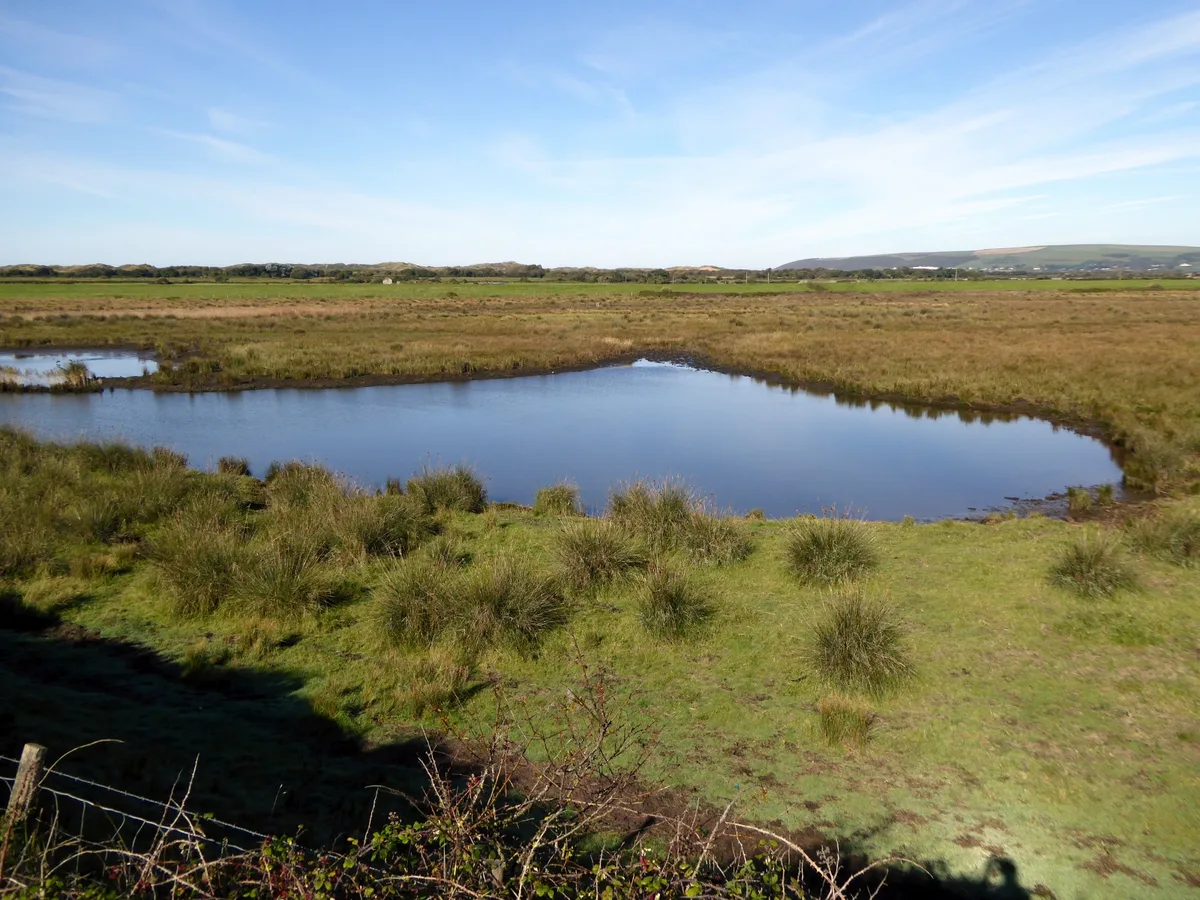
Braunton Canal
Braunton Canal — cut of the River Caen.

Wikimedia Commons contributors — see linked file page for photographer and licence licence
Plan your visit
- Typical visit
- 1 h–2 h
- Nearest railway station
- Barnstaple · 7.6 km
- Free entry
- Dog-friendly
About
Braunton Canal is a canal in the United Kingdom. Wikidata describes it as: "cut of the River Caen". Coordinates: 51.0950°, -4.1666°.
Photo gallery
Protected designations
- Site of Special Scientific Interest: Taw-Torridge Estuary SSSI
- Area of Outstanding Natural Beauty: North Devon
Designations sourced from Natural England open data under OGL v3.
From the Wikipedia article
The Braunton Canal is a cut made to straighten the course of the upper section of the River Caen, known as Braunton Pill, and to provide a new quay for the village of Braunton in North Devon, England. It crosses an area known as Braunton Marsh, which was the subject of Enclosure Acts in the early 19th Century, and was the only one of several schemes which was actually constructed.
Excerpt from Wikipedia under CC BY-SA 4.0. See the source article linked in Sources below.
Background
History
Before 1808, the area around Braunton, Velator, Wrafton and South Burrow was an extensive salt marsh. In that year, the Board of Agriculture sent Charles Vancouver to investigate the marsh, and his report recommended that it should be enclosed and reclaimed. This met with local approval, and James Green was appointed as engineer for the drainage scheme. Green commissioned John Pascoe to produce a survey and map (held by the Devon Record Office), which outlined two schemes. The first involved an embankment from the mouth of Braunton Pill to Bench Hill, with a canal from the Pill via Wrafton and the edge of Velator Marsh to some lime kilns near what is now Velator Quay. There were concerns…
Visiting
Velator Quay and the surrounding area is used as a mooring for small boats. In 2006 Braunton council blocked vehicular access to the quay as it was found to be in danger of collapse. An engineering survey was conducted on the quay in 2010, by consultants Bolgar Sykes, as the council were hoping to make it more of an amenity. The survey revealed several possible options for repair, ranging in cost from £80,000 to £400,000. The limited budget available to the council for such work meant that only basic repairs were considered. A subsequent report by Peter Lord, one of the parish counsellors, recommended that demolition of the quay would be the best long-term option, with the provision of a…
Sourced from Wikipedia under CC BY-SA 4.0.
- Coordinates
- 51.0950, -4.1666
- County
- Devon
- District
- North Devon
- Parish
- Braunton
- Postcode
- EX33 2NY
- Parliamentary constituency
- North Devon
- Nearest railway station
- Barnstaple — 7.6 km
Sources
- wikidata: Q4958301 (CC0)
- wikipedia: Braunton Canal (CC BY-SA 4.0)
- commons: River Caen Velator.jpg (CC BY-SA 4.0)
Other places nearby
Loading nearby places…
Nearby
 📷 3
📷 3Historic bridges · South West England
Velator Bridge
Velator Bridge — Grade II listed building-listed bridge in england-south-west, United Kingdom.
 📷 3
📷 3Archaeological sites · South West England
Braunton Great Field
Braunton Great Field — a archaeological in england-south-west, United Kingdom.
 📷 3
📷 3Viewpoints · South West England
Rescue Helicopter Viewing Area
Rescue Helicopter Viewing Area is a viewpoint in the United Kingdom.
 📷 5
📷 5Museums · South West England
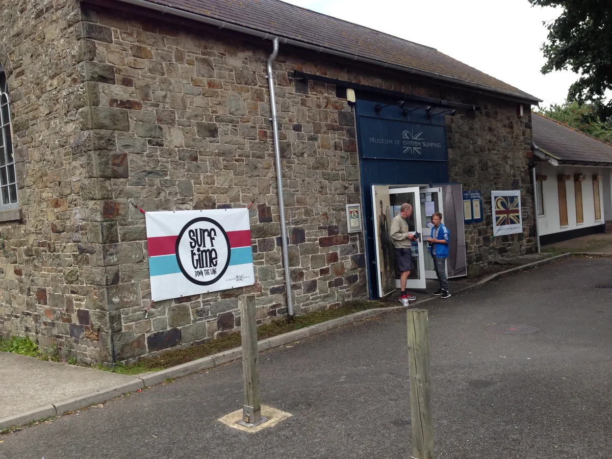
Museum of British Surfing
Museum of British Surfing — museum in Braunton, Devon, England, United Kingdom.
 📷 5
📷 5Wildlife reserves · South West England
Horsey Island, Devon
Horsey Island, Devon — nature reserve in Devon, England.
 📷 3
📷 3Museums · South West England
Braunton and District Museum
Braunton and District Museum — a museum in england-south-west, United Kingdom.
More places in this region
 📷 5
📷 5Canals · South West England
Bridgwater and Taunton Canal
Bridgwater and Taunton Canal — Canal in south-west England.
 📷 5
📷 5Canals · South West England
Bristol Feeder Canal
Bristol Feeder Canal is a canal in the United Kingdom.
 📷 5
📷 5Canals · South West England
Bude Canal
Bude Canal — Canal in Cornwall, England.
 📷 5
📷 5Canals · South West England
Cann Quarry Canal
Cann Quarry Canal — former canal in Devon, England.
Frequently asked questions
- Where is Braunton Canal?
- Braunton Canal is in Devon, South-West England, United Kingdom (postcode EX33 2NY), in the parish of Braunton.
- Is Braunton Canal a protected site?
- Yes — Braunton Canal is part of the Taw-Torridge Estuary SSSI Site of Special Scientific Interest and the North Devon National Landscape (AONB).
- Is Braunton Canal free to visit?
- Yes, Braunton Canal is free to enter.
- How do I get to Braunton Canal?
- The nearest railway station is Barnstaple, about 7.6 km away. Drivers can navigate to postcode EX33 2NY.