Mountains & hills · Central Scotland
Benarty Hill
Also known as: Beinn Artaidh, Benarty
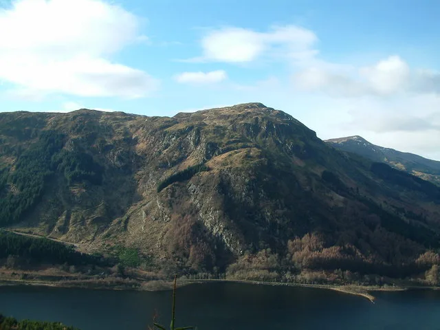
Benarty Hill — Named summit at 356 m.

Wikimedia Commons contributors — see linked file page for photographer and licence licence
Plan your visit
- Typical visit
- 3 h–8 h
- Best time of year
- Late spring – early autumn (May–Oct)
- Nearest railway station
- Lochgelly · 4.7 km
- Free entry
- Dog-friendly
About
Benarty Hill is a named summit in the United Kingdom. Also known as: Beinn Artaidh, Benarty. Wikidata describes it as: "Named summit at 356 m.". Coordinates: 56.1660°, -3.3642°.
Photo gallery
From the Wikipedia article
Benarty Hill (Scottish Gaelic: Beinn Artaidh, Scots: Benairty), locally simply Benarty, rises above and to the west of Ballingry, in the west of Fife, Scotland. The summit ridge, known as Mulla Craig, forms the boundary with Perth and Kinross. It is a prominent feature of the view from the M90 motorway, and from Kinross and Loch Leven. The lower slopes are steep on all sides, but the extensive heath around the summit is relatively flat. The name Benarty may come from Pictish meaning "stony mountain" (in relation to Mulla Craig) or Gaelic meaning either "mountain where there are bears" or possibly "at the high hill" (this would mean the Gaelic name would be Beinn Àrdaidh). From the north you can walk over the hill via the Sleeping Giant path accessed from RSPB Loch Leven visitors centre. The summit is easily accessible from its south side, where tracks and paths lead through the forest and up onto the summit heath. There are views across Loch Leven to the Lomond Hills, and across the Firth of Forth to the Lammermuir Hills and Pentland Hills. Distant views to the north and west are dominated by the Southern Highlands; on a clear day the profile of the Isle of Arran may be visible 80 miles to the west.
Excerpt from Wikipedia under CC BY-SA 4.0. See the source article linked in Sources below.
- Coordinates
- 56.1660, -3.3642
- District
- Perth and Kinross
- Postcode
- KY13 9LU
- Parliamentary constituency
- Perth and Kinross-shire
- Nearest railway station
- Lochgelly — 4.7 km
Sources
- osm: n29343816 (ODbL)
- wikipedia: Benarty Hill (CC BY-SA 4.0)
- commons: BenartyHill.jpg (CC BY-SA 4.0)
Other places nearby
Loading nearby places…
Nearby
Vineyards · Central Scotland
Benarty
Benarty — a UK vineyard in scotland central, producing English or Welsh wine from cool-climate grape varieties.
 📷 3
📷 3Viewpoints · Central Scotland
East Brackley Viewpoint
East Brackley Viewpoint is a viewpoint in the United Kingdom.
 📷 5
📷 5Memorials & monuments · Central Scotland
Binn Cottage and Monument, Parenwell
Binn Cottage and Monument, Parenwell — category B listed building-listed memorial in scotland-central, United Kingdom.
📷 5Historic bridges · Central Scotland
Parenwell Bridge
Parenwell Bridge — category B listed building-listed bridge in scotland-central, United Kingdom.
Vineyards · Central Scotland
Dunmore
Dunmore — a UK vineyard in scotland central, producing English or Welsh wine from cool-climate grape varieties.
 📷 3
📷 3Forts · Central Scotland
Dunmore Fort
Dunmore Fort is a fort in the United Kingdom.
More mountains in this region
 📷 3
📷 3Mountains & hills · Central Scotland
Abbey Hill
Abbey Hill — Named summit at 278 m.
 📷 3
📷 3Mountains & hills · Central Scotland
Aberlady Bay
Aberlady Bay — bay on the north coast of East Lothian, Scotland, UK.
 📷 3
📷 3Mountains & hills · Central Scotland
Allermuir Hill
Allermuir Hill — Named summit at 493 m.
 📷 3
📷 3Mountains & hills · Central Scotland
Ardnandave
Ardnandave — Named summit at 715 m.
Frequently asked questions
- Where is Benarty Hill?
- Benarty Hill is in central Scotland, United Kingdom (postcode KY13 9LU).
- Is Benarty Hill free to visit?
- Yes, Benarty Hill is free to enter.
- How do I get to Benarty Hill?
- The nearest railway station is Lochgelly, about 4.7 km away. Drivers can navigate to postcode KY13 9LU.