Mountains & hills · Scottish Highlands
Beinn Luibhean
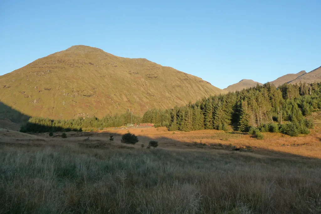
Beinn Luibhean — Named summit at 858 m.

Wikimedia Commons contributors — see linked file page for photographer and licence licence
Plan your visit
- Typical visit
- 3 h–8 h
- Best time of year
- Late spring – early autumn (May–Oct)
- Nearest railway station
- Arrochar and Tarbet · 7.7 km
- Free entry
- Dog-friendly
About
Beinn Luibhean is a named summit in the United Kingdom. Wikidata describes it as: "Named summit at 858 m.". Coordinates: 56.2313°, -4.8363°.
Photo gallery
From the Wikipedia article
Beinn Luibhean is one of the Arrochar Alps in the Argyll Highlands of Scotland, located to the northern side of Glen Croe between Loch Long in Dunbartonshire to the East and Loch Fyne in the Remote Highlands of Argyll to the West. The landscape to the West of Loch Long changes as the shoreline provides the gateway to Argyll, the district in the Western Highlands of Scotland that form the first ingredients to a wilderness and has a real sense of remoteness and isolation from the Lowlands and populated parts of the Central Belt. The Arrochar Alps are a Mountain Range which Run from the Loch Goil in the South and West towards Tyndrum in the North. Beinn Luibhean stands at a height of 2821 ft, 859.7 m. The Nearest Mountains to Beinn Luibhean include The Cobbler, Beinn Ime and Beinn Narnain.
Excerpt from Wikipedia under CC BY-SA 4.0. See the source article linked in Sources below.
- Coordinates
- 56.2313, -4.8363
- Address
- Scotland
- Nearest railway station
- Arrochar and Tarbet — 7.7 km
- Official site
- www.hill-bagging.co.uk
Sources
- osm: n268767659 (ODbL)
- wikipedia: Beinn Luibhean (CC BY-SA 4.0)
- commons: View towards Beinn Luibhean - geograph.org.uk - 1657454.jpg (CC BY-SA 4.0)
Other places nearby
Loading nearby places…
Nearby
 📷 3
📷 3Natural landmarks · Scottish Highlands
Beinn Luibhean
Beinn Luibhean — mountain in Argyll and Bute, Scotland, UK.
 📷 5
📷 5National parks · Scottish Highlands
Arrochar Alps
Arrochar Alps in Scotland Islands, United Kingdom.
 📷 3
📷 3Natural landmarks · Scottish Highlands
Beinn Ìme
Beinn Ìme — 1011m high mountain in Argyll and Bute, Scotland, UK.
 📷 5
📷 5National parks · Scottish Highlands
Loch Restil
Loch Restil in Scotland Islands, United Kingdom.
 📷 4
📷 4Viewpoints · Scottish Highlands
Rest And Be Thankful
Rest And Be Thankful is a viewpoint in the United Kingdom.
 📷 3
📷 3Mountains & hills · Scottish Highlands
Beinn Ìme
Beinn Ìme — Named summit at 1011 m.
More mountains in this region
 📷 3
📷 3Mountains & hills · Scottish Highlands
A' Bhuidheanach Bheag
A' Bhuidheanach Bheag — Named summit at 936 m.
 📷 3
📷 3Mountains & hills · Scottish Highlands
A' Chailleach
A' Chailleach — Named summit at 997 m.
 📷 3
📷 3Mountains & hills · Scottish Highlands
A' Chailleach
A' Chailleach — Named summit at 930 m.
 📷 3
📷 3Mountains & hills · Scottish Highlands
A' Chaoirnich
A' Chaoirnich — Named summit at 875 m.
Frequently asked questions
- Where is Beinn Luibhean?
- Beinn Luibhean is in the Scottish Highlands, United Kingdom.
- Is Beinn Luibhean free to visit?
- Yes, Beinn Luibhean is free to enter.
- How do I get to Beinn Luibhean?
- The nearest railway station is Arrochar and Tarbet, about 7.7 km away.