Towns & cities · South West England
Bawdrip
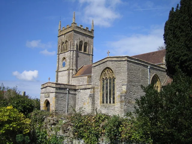
Bawdrip — village in Somerset, England, UK.

Wikimedia Commons contributors — see linked file page for photographer and licence licence
Plan your visit
- Typical visit
- 3 h–6 h
- Nearest railway station
- Bridgwater · 4.1 km
- Free entry
- Family-friendly
- Dog-friendly
About
Bawdrip is a town, city, village or settlement in the United Kingdom. Recent population estimates put it at around 485 people. Address: TA7. Wikidata describes it as: "village in Somerset, England, UK". Coordinates: 51.1510°, -2.9440°.
Photo gallery
Protected designations
- National Nature Reserve: SOMERSET WETLANDS
Designations sourced from Natural England open data under OGL v3.
From the Wikipedia article
Bawdrip is a village and civil parish in Somerset, England. The village is on the south side of the Polden Hills about 4 miles (6.4 km) north-east of Bridgwater. At the 2011 census the parish had a population of 506. The parish includes the hamlets of Bradney, Horsey and Knowle.
Excerpt from Wikipedia under CC BY-SA 4.0. See the source article linked in Sources below.
Background
History
Some sources claim that in 1800, the iron age Polden Hill Hoard was found on Knowle Hill in the parish of Bawdrip, although other sources suggest the hoard was found in the near by village of Edington. The hoard is held in the British Museum's collection. In 1086, Domesday Book recorded a settlement at Bagetrepe with 27 households and one mill, and another at Hursi with 19 households, both in North Petherton hundred. There may have been quarrying on the hillside in the 15th century and lias was dug in the early 19th. Lime was being extracted and processed in the extreme western tip of the parish under Puriton Hill by 1886 and until 1973 in association with the cement works at Dunball. Salt…
Sourced from Wikipedia under CC BY-SA 4.0.
- Coordinates
- 51.1510, -2.9440
- District
- Somerset
- Parish
- Bawdrip
- Postcode
- TA7
- Parliamentary constituency
- Bridgwater
- Population
- 485
- Nearest railway station
- Bridgwater — 4.1 km
- Official site
- www.somersetintelligence.org.uk
Sources
- wikidata: Q942574 (CC0)
- wikipedia: Bawdrip (CC BY-SA 4.0)
- commons: St Michael and All Angels Church, Bawdrip - geograph.org.uk - 85565.jpg (CC BY-SA 4.0)
Other places nearby
Loading nearby places…
Nearby
Caravan parks · South West England
Fairways Holiday Park
Fairways Holiday Park — a caravan park in england south west.
 📷 5
📷 5Historic churches · South West England
Church of St Mary, Chedzoy
Church of St Mary, Chedzoy — church in Chedzoy, Somerset, England, UK.
 📷 5
📷 5Historic churches · South West England
Church of St Mary, Woolavington
Church of St Mary, Woolavington — church in Woolavington, Somerset, England, UK.
 📷 5
📷 5Memorials & monuments · South West England
Willow Man
Willow Man is a memorial in the United Kingdom.
 📷 4
📷 4Towns & cities · South West England
Stawell
Stawell — village and parish in Somerset, England.
 📷 5
📷 5Historic churches · South West England
Church of St Michael and All Angels, Puriton
Church of St Michael and All Angels, Puriton — church in Puriton, Somerset, England, UK.
More towns in this region
 Flagship📷 10
Towns & cities · South West England
All Saints
All Saints — village and civil parish in Devon, England, UK.
 Flagship📷 10
Towns & cities · South West England
Axmouth
Axmouth — village and civil parish in Devon, England, UK.
 ★ Iconic📷 10
Towns & cities · South West England
Beer
Beer — village and civil parish in Devon, UK.
 Flagship📷 10
Towns & cities · South West England
Branscombe
Branscombe — village and civil parish in Devon, UK.
Frequently asked questions
- Where is Bawdrip?
- Bawdrip is in South-West England, United Kingdom (postcode TA7), in the parish of Bawdrip.
- Is Bawdrip a protected site?
- Yes — Bawdrip is part of the SOMERSET WETLANDS National Nature Reserve.
- Is Bawdrip free to visit?
- Yes, Bawdrip is free to enter.
- How do I get to Bawdrip?
- The nearest railway station is Bridgwater, about 4.1 km away. Drivers can navigate to postcode TA7.