Towns & cities · North Wales
Baddiley
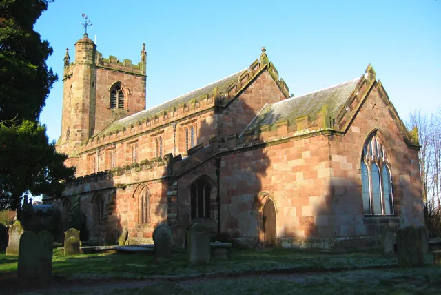
Baddiley — village and civil parish in Cheshire East, United Kingdom.

Wikimedia Commons contributors — see linked file page for photographer and licence licence
Plan your visit
- Typical visit
- 3 h–6 h
- Nearest railway station
- Wrenbury · 1.6 km
- Free entry
- Family-friendly
- Dog-friendly
About
Baddiley is a town, city, village or settlement in the United Kingdom. Recent population estimates put it at around 226 people. Address: CW5. Wikidata describes it as: "village and civil parish in Cheshire East, United Kingdom". Coordinates: 53.0333°, -2.6000°.
Photo gallery
From the Wikipedia article
Baddiley is a scattered settlement and civil parish in the unitary authority of Cheshire East and the ceremonial county of Cheshire, England. The civil parish also includes the north-western part of the village of Ravensmoor (also in the parish of Burland), as well as the small settlements of Baddiley Hulse, Batterley Hill, and parts of Gradeley Green and Swanley. According to the 2001 Census the parish had a total population of 226, increasing at the 2011 Census to 249. The largest settlement within the parish, Ravensmoor centres on a crossroads with a small village green. It lies around six miles (ten kilometres) southwest of Crewe.
Excerpt from Wikipedia under CC BY-SA 4.0. See the source article linked in Sources below.
Background
History
Baddiley is listed in the Domesday Book as Bedelie, and the manor then belonged to the Praers family. The ancient manor was more extensive than the modern parish, also including Faddiley, which lies to the north west. In the first half of the 13th century, part of the Baddiley parish was granted to Combermere Abbey, a Cistercian monastery which had been endowed on its foundation in 1133 with a large area of land to the south; in 1355, the abbey also acquired the right to appoint the priest of the Baddiley church in exchange for land at Baddiley Grange. (Baddiley is not, however, included among the lands surrendered to the government when the abbey was dissolved in 1538.) By the 14th…
Sourced from Wikipedia under CC BY-SA 4.0.
- Coordinates
- 53.0333, -2.6000
- District
- Cheshire East
- Parish
- Wrenbury cum Frith
- Postcode
- CW5
- Parliamentary constituency
- Chester South and Eddisbury
- Population
- 226
- Nearest railway station
- Wrenbury — 1.6 km
Sources
- wikidata: Q643249 (CC0)
- wikipedia: Baddiley (CC BY-SA 4.0)
- commons: St Michaels Baddiley.jpg (CC BY-SA 4.0)
Other places nearby
Loading nearby places…
Nearby
 📷 3
📷 3Historic bridges · North Wales
Wrenbury Church Bridge
Wrenbury Church Bridge — Grade II* listed building-listed bridge in wales-north, United Kingdom.
Campsites · North Wales
Cotton Arms
Cotton Arms — a campsite in wales north.
 📷 3
📷 3Historic churches · North Wales
St Margaret's Church
St Margaret's Church — church in Wrenbury, Cheshire East, Cheshire, England, UK.
 📷 3
📷 3Historic bridges · North Wales
Wrenbury wooden lifting bridge
Wrenbury wooden lifting bridge — a Grade II*-listed bridge in wales-north, United Kingdom.
 📷 5
📷 5Towns & cities · North Wales
Wrenbury-cum-Frith
Wrenbury-cum-Frith — village and civil parish in Cheshire, England, UK.
 📷 3
📷 3Historic houses · North Wales
Elm House
Elm House — house in Wrenbury cum Frith, Cheshire East, Cheshire, England, UK.
More towns in this region
 📷 5
📷 5Towns & cities · North Wales
Bangor
Bangor — city in Gwynedd, Wales.
 Flagship📷 3
Towns & cities · North Wales
Beddgelert
Beddgelert — village and community in Gwynedd, Wales.
 Flagship📷 5
Towns & cities · North Wales
Chester
Chester — city in Cheshire, England.
 Flagship📷 3
Towns & cities · North Wales
Liverpool
Liverpool — city in Merseyside, England, United Kingdom.
Frequently asked questions
- Where is Baddiley?
- Baddiley is in North Wales, United Kingdom (postcode CW5), in the parish of Wrenbury cum Frith.
- Is Baddiley free to visit?
- Yes, Baddiley is free to enter.
- How do I get to Baddiley?
- The nearest railway station is Wrenbury, about 1.6 km away. Drivers can navigate to postcode CW5.