Natural landmarks · Scottish Highlands
An Ruadh-stac
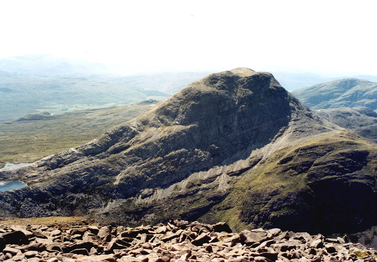
An Ruadh-stac — mountain in Highland, Scotland, UK.

Wikimedia Commons contributors — see linked file page for photographer and licence licence
Plan your visit
- Typical visit
- 1 h–2 h
- Nearest railway station
- Strathcarron · 6.3 km
- Free entry
- Dog-friendly
About
An Ruadh-stac is a named natural landmark in the United Kingdom. Part of Northwest Highlands. Wikidata describes it as: "mountain in Highland, Scotland, UK". Coordinates: 57.4758°, -5.4678°.
Photo gallery
From the Wikipedia article
An Ruadh-stac is a Scottish mountain situated in the Wester Ross region of the Highland council area. It is located 26 km north east of Kyle of Lochalsh.
Excerpt from Wikipedia under CC BY-SA 4.0. See the source article linked in Sources below.
Background
Description
An Ruadh-stac reaches a height of 890 metres (2926 feet) making it the 30th highest Corbett, it also qualifies as a Marilyn. It is a distinguished looking mountain which is prominent in views because of its light grey coloured quartzite rocks, it stands in the ancient Coulin hunting forest, an area of rough mountainous country between Glen Carron and Glen Torridon. The mountain is situated four km from the nearest public road but there are good stalkers paths within the deer forest which aid access to the foot of the mountain. An Ruadh-stac is closely associated with the adjoining Munro of Maol Cheann-dearg with which it is often climbed. The mountain's Gaelic name translates as the Red…
Sourced from Wikipedia under CC BY-SA 4.0.
- Coordinates
- 57.4758, -5.4678
- Address
- Wester Ross, Scotland
- Nearest railway station
- Strathcarron — 6.3 km
Sources
- wikidata: Q3397996 (CC0)
- wikipedia: An Ruadh-stac (CC BY-SA 4.0)
- commons: An Ruadh-stac from MCD.jpg (CC BY-SA 4.0)
Other places nearby
Loading nearby places…
Nearby
 📷 3
📷 3Mountains & hills · Scottish Highlands
An Ruadh-stac
An Ruadh-stac — Named summit at 892 m.
 📷 3
📷 3Mountains & hills · Scottish Highlands
Meall nan Ceapairean
Meall nan Ceapairean — a mountain in scotland-highlands, United Kingdom.
 📷 3
📷 3Natural landmarks · Scottish Highlands
Maol Chean-dearg
Maol Chean-dearg — 933m high mountain in Highland, Scotland, UK.
 📷 3
📷 3Mountains & hills · Scottish Highlands
Maol Chean-dearg
Maol Chean-dearg — Named summit at 933 m.
 📷 3
📷 3Natural landmarks · Scottish Highlands
Beinn Damh
Beinn Damh — mountain in Highland, Scotland, UK.
 📷 3
📷 3Mountains & hills · Scottish Highlands
Beinn Damh
Beinn Damh — Named summit at 903 m.
More natural landmarks in this region
 Flagship📷 3
Natural landmarks · Scottish Highlands
Dunalastair Water
Dunalastair Water — lake in Perth and Kinross, Scotland, UK, on the River Tummel.
 Flagship📷 3
Natural landmarks · Scottish Highlands
Loch Arkaig
Loch Arkaig — lake in Highland, Scotland, UK, outflows east to River Arkaig.
 Flagship📷 3
Natural landmarks · Scottish Highlands
Loch Assynt
Loch Assynt — lake in Highland, Scotland, UK, outflows to the River Inver and Loch na Garbh Uidhe.
 Flagship📷 3
Natural landmarks · Scottish Highlands
Loch Awe
Loch Awe — lake in Argyll and Bute, Scotland, UK, outflows to the River Awe.
Frequently asked questions
- Where is An Ruadh-stac?
- An Ruadh-stac is in the Scottish Highlands, United Kingdom.
- Is An Ruadh-stac free to visit?
- Yes, An Ruadh-stac is free to enter.
- How do I get to An Ruadh-stac?
- The nearest railway station is Strathcarron, about 6.3 km away.