Beaches · South Wales
Abermawr
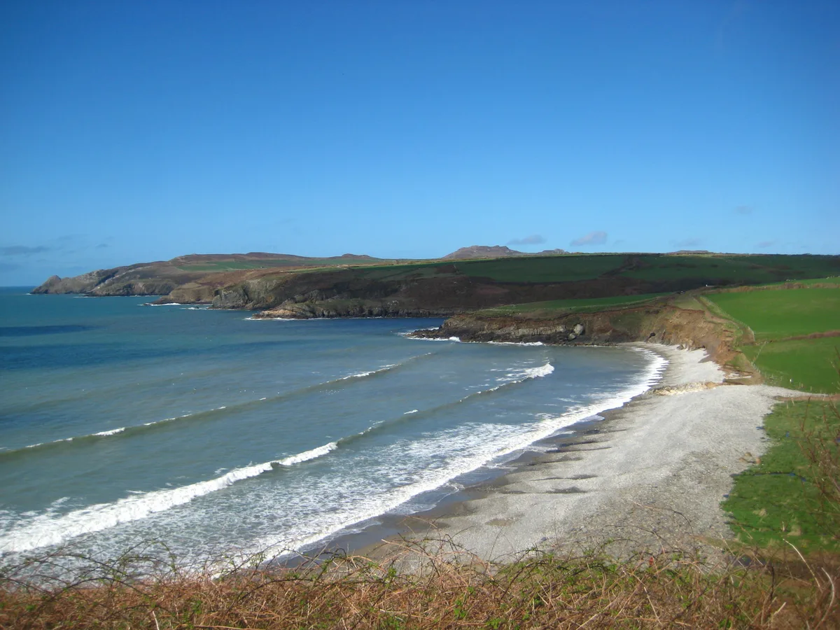
Abermawr — beach and coastline in Pembrokeshire.

Wikimedia Commons contributors — see linked file page for photographer and licence licence
Plan your visit
- Typical visit
- 1 h–3 h
- Best time of year
- Summer (Jun–Aug)
- Nearest railway station
- Fishguard and Goodwick · 7.3 km
- Free entry
- Family-friendly
- Dog-friendly
About
Abermawr is a named beach on the United Kingdom coastline. Heritage designation: Site of Special Scientific Interest. Wikidata describes it as: "beach and coastline in Pembrokeshire". Coordinates: 51.9694°, -5.0853°.
Photo gallery
From the Wikipedia article
Abermawr is a stretch of coastline and is regarded as a Site of Special Scientific Interest in Pembrokeshire, Wales. Abermawr is a mostly shingle beach with marsh and woodland behind it. It is popular with many walkers who are walking along the coast past Porthgain, Abereiddi and Abercastle. The large pebble bank of the bay was created by a storm on 25 October 1859. The currents at Abermawr can be hazardous but the headlands are low so are less gusty.
Excerpt from Wikipedia under CC BY-SA 4.0. See the source article linked in Sources below.
Background
History
During the 1840s, the South Wales Railway (SWR), led by engineer Isambard Kingdom Brunel, began to explore ways of constructing a rail link to the coast, opening up a passenger train route from London via the Great Western Railway to link with passenger ships sailing from Great Britain to Ireland and to America. In 1847 Captain Christopher Claxton surveyed the St George's Channel to try to ascertain the best route for passenger ships to cross. Abermawr was considered briefly as the SWR railway terminal, but after surveys by Brunel, the line was re-routed to terminate at instead. An Act of Parliament to abandon these works and redirect to Neyland was granted on 17 June 1862. On 27 July 1866…
Sourced from Wikipedia under CC BY-SA 4.0.
- Coordinates
- 51.9694, -5.0853
- District
- Pembrokeshire
- Parish
- Pencaer
- Postcode
- SA62 5UU
- Parliamentary constituency
- Ceredigion Preseli
- Nearest railway station
- Fishguard and Goodwick — 7.3 km
- Official site
- www.visitpembrokeshire.com
Sources
- wikidata: Q4667129 (CC0)
- wikipedia: Abermawr (CC BY-SA 4.0)
- commons: Abermawr.JPG (CC BY-SA 4.0)
Other places nearby
Loading nearby places…
Nearby
 📷 3
📷 3Beaches · South Wales
Abermawr
Abermawr — Beach (pebble;sand).
 📷 3
📷 3Beaches · South Wales
Aberbach
Aberbach — Beach (pebble;sand).
Vineyards · South Wales
Carreg Golchfa
Carreg Golchfa — a UK vineyard in wales south, producing English or Welsh wine from cool-climate grape varieties.
 📷 3
📷 3Beaches · South Wales
Porth Dwgan
Porth Dwgan is a beach in the United Kingdom.
 📷 5
📷 5Historic houses · South Wales
Tregwynt
Tregwynt — Grade II* listed house in Pembrokeshire.
Vineyards · South Wales
Castell Coch, Penmorfa
Castell Coch, Penmorfa — a UK vineyard in wales south, producing English or Welsh wine from cool-climate grape varieties.
More beaches in this region
 📷 3
📷 3Beaches · South Wales
ABCC Meeting Point
ABCC Meeting Point is a beach in the United Kingdom.
 📷 3
📷 3Beaches · South Wales
Aber Castle
Aber Castle is a beach in the United Kingdom.
 📷 3
📷 3Beaches · South Wales
Aber Mawr
Aber Mawr is a beach in the United Kingdom.
 📷 4
📷 4Beaches · South Wales
Aberavon Beach
Aberavon Beach is a beach in the United Kingdom.
Frequently asked questions
- Where is Abermawr?
- Abermawr is in South Wales, United Kingdom (postcode SA62 5UU), in the parish of Pencaer.
- Is Abermawr a listed building?
- Abermawr is officially recognised as Site of Special Scientific Interest listed.
- Is Abermawr free to visit?
- Yes, Abermawr is free to enter.
- How do I get to Abermawr?
- The nearest railway station is Fishguard and Goodwick, about 7.3 km away. Drivers can navigate to postcode SA62 5UU.