Forests & woodlands · West Midlands
Wymington Meadow
Wymington Meadow is a forest or woodland in the United Kingdom.

Wikimedia Commons contributors — see linked file page for photographer and licence licence
Plan your visit
- Typical visit
- 1 h–3 h
- Nearest railway station
- Wellingborough · 7.4 km
- Free entry
- Family-friendly
- Dog-friendly
About
Wymington Meadow is a named forest, woodland or nature reserve in the United Kingdom. Coordinates: 52.2590°, -0.5960°. This entry is part of The Great Britain Guide, a free, ad-free, open-data tourist directory.
Photo gallery
Protected designations
- Site of Special Scientific Interest: Upper Nene Valley Gravel Pits SSSI
Designations sourced from Natural England open data under OGL v3.
From the Wikipedia article
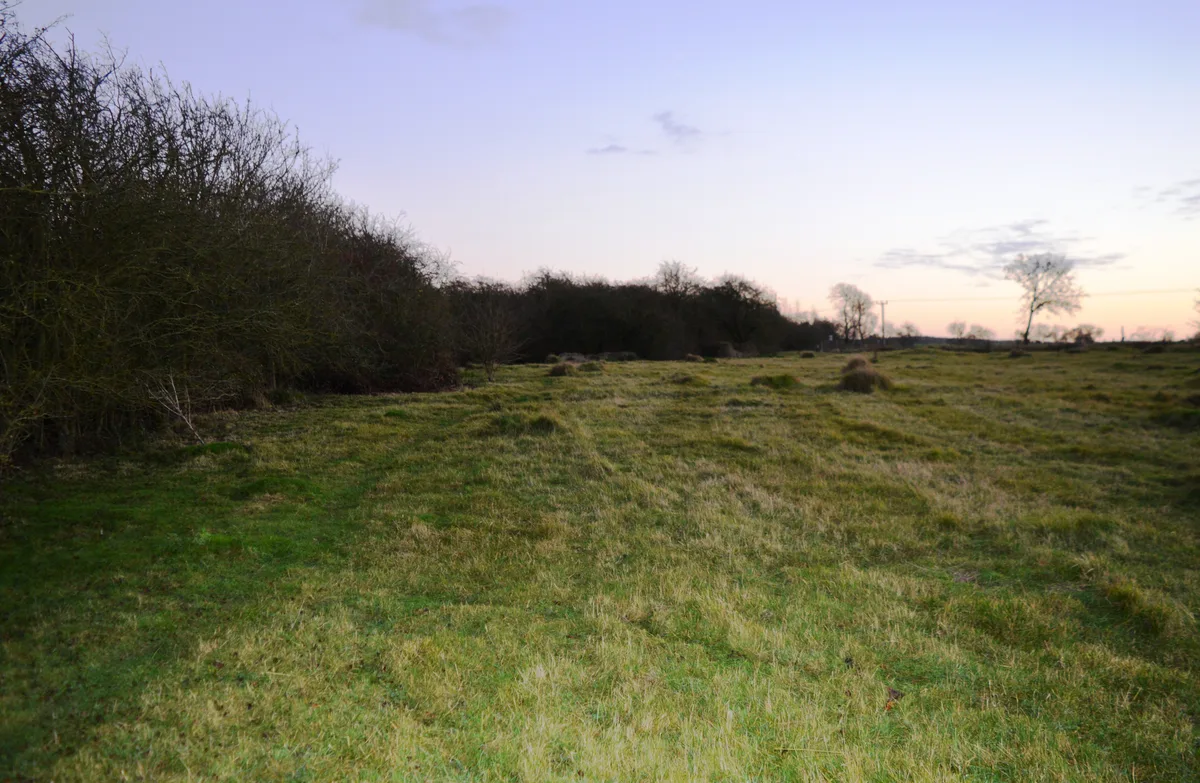
Wymington Meadow is a nature reserve south of Wymington in Bedfordshire. It is approximately one hectare, and is managed by the Wildlife Trust for Bedfordshire, Cambridgeshire and Northamptonshire. The site is a triangular meadow in the corner where two railway lines merge. It was cut off when the railways were constructed in the 1850s, and at the northern end there are traces of the ancient ridge and furrow method of ploughing. The site has a wide range of flowers, such as cowslip, salad burnet and quaking grass. A small stream and hedgerows provide additional habitats for wildlife. There is access by a footpath from South Grove. Cross the railway by a footbridge, cross to the other side of the field and turn left. Pass (but do not cross) a second footbridge. The path can be very muddy. The site is close to Sharnbrook Summit, but there no direct access between the reserves as they are separated by the railway lines.
Excerpt from Wikipedia under CC BY-SA 4.0. See the source article linked in Sources below.
- Coordinates
- 52.2590, -0.5960
- District
- Bedford
- Parish
- Wymington
- Postcode
- NN10 9LU
- Parliamentary constituency
- North Bedfordshire
- Nearest railway station
- Wellingborough — 7.4 km
Sources
- osm: w958263520 (ODbL)
- wikipedia: Wymington Meadow (CC BY-SA 4.0)
- commons: Wymington Meadow 5.JPG (CC BY-SA 4.0)
Other places nearby
Loading nearby places…
Nearby
 📷 3
📷 3Wildlife reserves · West Midlands
Wymington Meadow
Wymington Meadow — nature reserve in the United Kingdom.
 📷 3
📷 3Forests & woodlands · West Midlands
Sharnbrook Summit
Sharnbrook Summit is a forest or woodland in the United Kingdom.
 📷 3
📷 3Historic churches · West Midlands
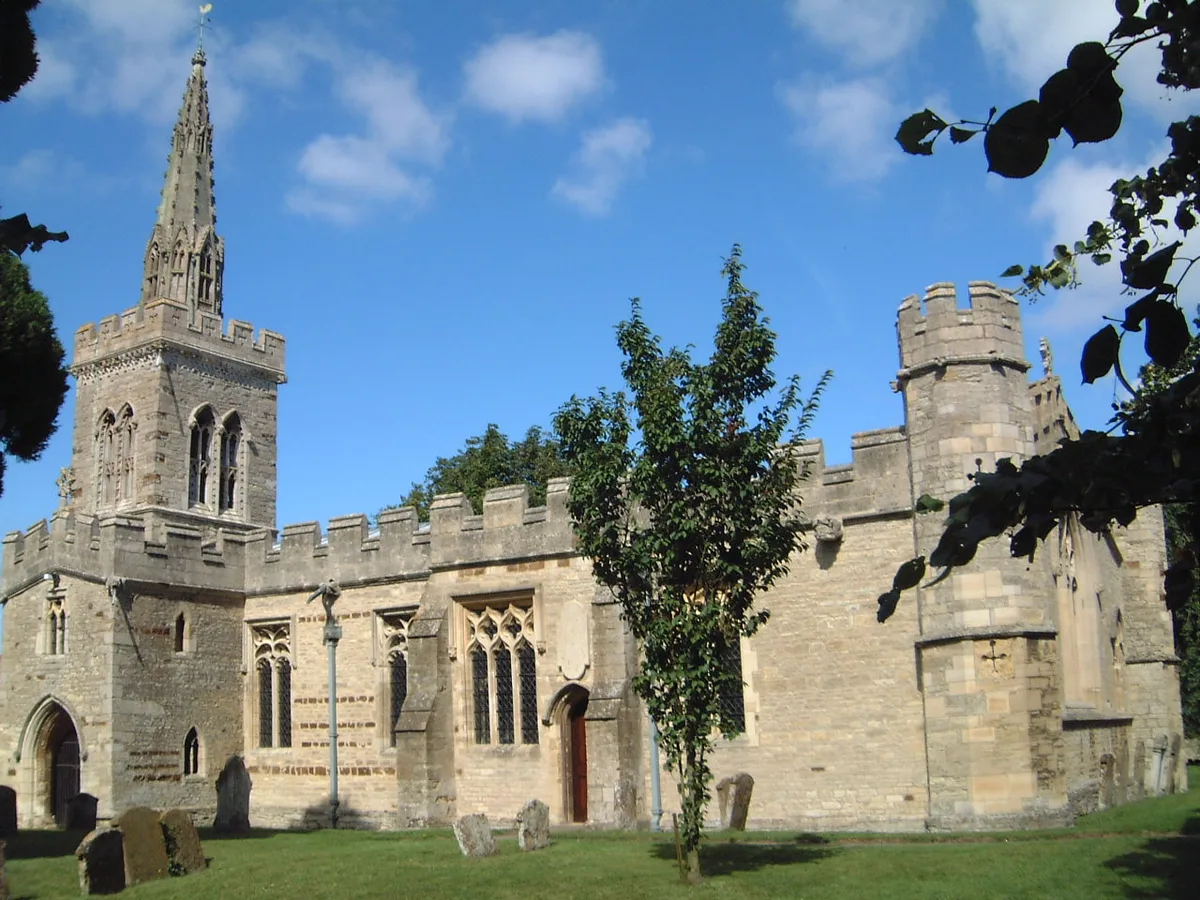
Church of St Lawrence, Wymington
Church of St Lawrence, Wymington — Grade I listed church in Wymington, Bedford, Bedfordshire, England, UK.
 📷 4
📷 4Towns & cities · West Midlands
Wymington
Wymington — village and civil parish in Bedfordshire, UK.
 📷 3
📷 3Wildlife reserves · West Midlands
Sharnbrook Summit
Sharnbrook Summit — nature reserve in the United Kingdom.
 📷 3
📷 3Castles · West Midlands
Podington Castle
Podington Castle — castle in the United Kingdom.
More forests in this region
 📷 3
📷 3Forests & woodlands · West Midlands
Abington Meadows Nature Reserve
Abington Meadows Nature Reserve is a forest or woodland in the United Kingdom.
_(geograph_2935627).jpg?width=1200) 📷 3
📷 3Forests & woodlands · West Midlands
Adderbury Lakes
Adderbury Lakes is a forest or woodland in the United Kingdom.
 📷 3
📷 3Forests & woodlands · West Midlands
Alcott Wood
Alcott Wood is a forest or woodland in the United Kingdom.
 📷 3
📷 3Forests & woodlands · West Midlands
Alvecote Meadows Nature Reserve
Alvecote Meadows Nature Reserve is a forest or woodland in the United Kingdom.
Frequently asked questions
- Where is Wymington Meadow?
- Wymington Meadow is in the West Midlands, United Kingdom (postcode NN10 9LU), in the parish of Wymington.
- Is Wymington Meadow a protected site?
- Yes — Wymington Meadow is part of the Upper Nene Valley Gravel Pits SSSI Site of Special Scientific Interest.
- Is Wymington Meadow free to visit?
- Yes, Wymington Meadow is free to enter.
- How do I get to Wymington Meadow?
- The nearest railway station is Wellingborough, about 7.4 km away. Drivers can navigate to postcode NN10 9LU.