Towns & cities · South East England
Wool
Also known as: Wool, Dorset
Wool — village and civil parish in Dorset, England, UK.

Wikimedia Commons contributors — see linked file page for photographer and licence licence
Plan your visit
- Typical visit
- 3 h–6 h
- Nearest railway station
- Wool · 0.2 km
- Free entry
- Family-friendly
- Dog-friendly
About
Wool is a town, city, village or settlement in the United Kingdom. Recent population estimates put it at around 2,290 people. Wikidata describes it as: "village and civil parish in Dorset, England, UK". Coordinates: 50.6800°, -2.2230°.
Photo gallery
Protected designations
- Site of Special Scientific Interest: River Frome SSSI
- Area of Outstanding Natural Beauty: Dorset
Designations sourced from Natural England open data under OGL v3.
From the Wikipedia article
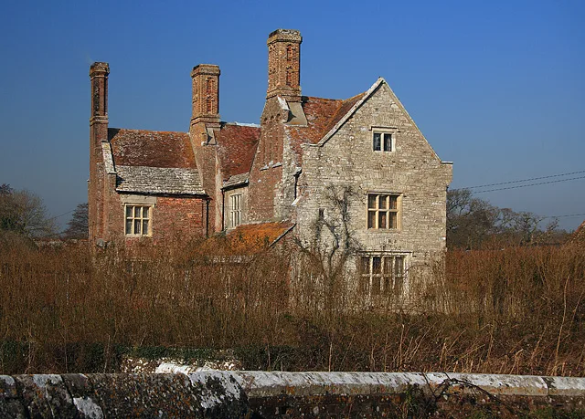
Wool is a large village, civil parish and electoral ward in south Dorset, England. In the 2011 census the parish – which includes Bovington Camp army base to the north – had 2,015 households and a population of 5,310. The village lies at a historic bridging point on the River Frome, halfway between Dorchester and Wareham. Woolbridge Manor House, a 17th-century building, is a prominent feature just outside the village and the location of Tess's honeymoon in Thomas Hardy's Tess of the D'Urbervilles. Other prominent features of the village include the medieval church of Holy Rood, the railway station on the South West Main Line from London Waterloo to Weymouth, and the thatched cottages along Spring Street. The place-name 'Wool' is first attested in Anglo-Saxon Writs from 1002 to 1012, where it appears as Wyllon. In the Domesday Book of 1086 it appears as Wille and Welle, and as Welles in 1212 in the Book of Fees. The name means 'springs' in the sense of the related word wells. Near Wool, to the east of the village, are the ruins of Bindon Abbey, which was demolished in the Dissolution of the Monasteries of 1539, the stone being used to build castles in Portland, Lulworth and Sandsfoot. A small single-lane hump-backed stone bridge, a Grade II* listed structure about 200m north from the railway station, is no longer used for vehicular traffic. The place name Wullebrigg, recorded in 1244, indicates a crossing here in the thirteenth century and there is an extant record from 1343 of a bridge crossing the River Frome at this point. It has a stone half-way along it stating that those who deface or damage the bridge will be transported (sent to Australia or another penal colony) for the rest of their lives. In January 2018 one of the bridge's stone parapets collapsed, undermined by floodwater, but the arches remained undamaged. Local places of interest include The Tank Museum and Monkey World. Nearby hamlets include East Burton and Giddy Green.
Excerpt from Wikipedia under CC BY-SA 4.0. See the source article linked in Sources below.
- Coordinates
- 50.6800, -2.2230
- District
- Dorset
- Parish
- Wool
- Postcode
- BH20 6DH
- Parliamentary constituency
- South Dorset
- Population
- 2,290
- Nearest railway station
- Wool — 0.2 km
Sources
- wikidata: Q1218503 (CC0)
- wikipedia: Wool, Dorset (CC BY-SA 4.0)
- commons: Wool, frontages and phone box, High Street - geograph.org.uk - 1415372.jpg (CC BY-SA 4.0)
Other places nearby
Loading nearby places…
Nearby
Campsites · South East England
Whitemead Caravan Park
Whitemead Caravan Park — a campsite in england south east.
 📷 5
📷 5Historic houses · South East England
Bindon Abbey
Bindon Abbey — house and chapel in Wool, Dorset, England, UK.
 📷 5
📷 5Historic bridges · South East England
Wool Bridge
Wool Bridge — scheduled monument-listed bridge in england-south-east, United Kingdom.
 📷 5
📷 5Stately homes · South East England
Woolbridge Manor House
Woolbridge Manor House — manor house in East Stoke, Dorset, England, UK.
 📷 5
📷 5Memorials & monuments · South East England
Frome Dale Bed & Breakfast
Frome Dale Bed & Breakfast — a memorial in england-south-east, United Kingdom.
 📷 5
📷 5Historic bridges · South East England
Bridge In Lane South West Of Bindon Mill
Bridge In Lane South West Of Bindon Mill — Grade II listed building-listed bridge in england-south-east, United Kingdom.
More towns in this region
 Flagship📷 10
Towns & cities · South East England
Aldermaston
Aldermaston — village and civil parish in West Berkshire in England, UK.
 Flagship📷 10
Towns & cities · South East England
Aldingbourne
Aldingbourne — village and civil parish in Arun, West Sussex, UK.
 Flagship📷 10
Towns & cities · South East England
Aldington
Aldington — village and civil parish in the Ashford District of Kent, England.
 Flagship📷 10
Towns & cities · South East England
Aldworth
Aldworth — village and civil parish in the English county of Berkshire.
Frequently asked questions
- Where is Wool?
- Wool is in South-East England, United Kingdom (postcode BH20 6DH), in the parish of Wool.
- Is Wool a protected site?
- Yes — Wool is part of the River Frome SSSI Site of Special Scientific Interest and the Dorset National Landscape (AONB).
- Is Wool free to visit?
- Yes, Wool is free to enter.
- How do I get to Wool?
- The nearest railway station is Wool, about 0.2 km away. Drivers can navigate to postcode BH20 6DH.