Towns & cities · South East England
West Grinstead
West Grinstead — village in West Sussex, England, UK.

Wikimedia Commons contributors — see linked file page for photographer and licence licence
Plan your visit
- Typical visit
- 3 h–6 h
- Nearest railway station
- Christ's Hospital · 8.8 km
- Free entry
- Family-friendly
- Dog-friendly
About
West Grinstead is a town, city, village or settlement in the United Kingdom. It covers approximately 26 km². Recent population estimates put it at around 2,892 people. Wikidata describes it as: "village in West Sussex, England, UK". Coordinates: 50.9741°, -0.3331°.
Photo gallery
From the Wikipedia article
West Grinstead () is a village and civil parish in the Horsham District of West Sussex, England. It lies just off the B2135 road four miles (6.3 km) northwest from Henfield. It is within the ancient division of the Rape of Bramber. The western River Adur flows through the village. The parish of West Grinstead covers an area of 2584 hectares (6382 acres) and consists of the villages of West Grinstead, Littleworth, Partridge Green and Dial Post. In the 2001 census 2934 people lived in 1099 households, of whom 1547 were economically active. At the 2011 Census the population was 3,054 The village should not be confused with the much larger town of East Grinstead which lies 17.5 miles (28 km) to the north-east.
Excerpt from Wikipedia under CC BY-SA 4.0. See the source article linked in Sources below.
Background
History
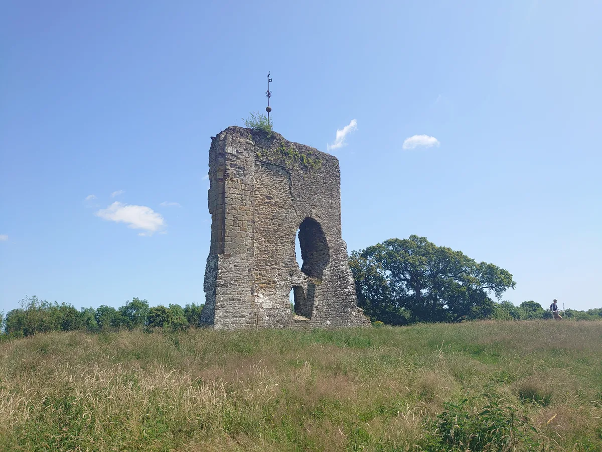
Knepp Castle is located to the west of the village near the A24. It was a motte castle and founded in the 12th century by William de Braose. Some remains of the keep still stand. The modern Knepp Castle nearby is a castellated mansion by John Nash.
Sourced from Wikipedia under CC BY-SA 4.0.
- Coordinates
- 50.9741, -0.3331
- County
- West Sussex
- District
- Horsham
- Parish
- West Grinstead
- Postcode
- RH13 8NF
- Parliamentary constituency
- Horsham
- Population
- 2,892
- Nearest railway station
- Christ's Hospital — 8.8 km
- Official site
- www.wgpublications.com
Sources
- wikidata: Q847396 (CC0)
- wikipedia: West Grinstead (CC BY-SA 4.0)
- commons: Knepp Castle - geograph.org.uk - 238677.jpg (CC BY-SA 4.0)
Other places nearby
Loading nearby places…
Nearby
 📷 5
📷 5Canals · South East England
Baybridge Canal
Baybridge Canal is a canal in the United Kingdom.
 📷 5
📷 5Archaeological sites · South East England
Baybridge Wharf
Baybridge Wharf — a archaeological in england-south-east, United Kingdom.
 📷 5
📷 5Historic houses · South East England
Priest's House
Priest's House is a historic house in the United Kingdom.
 📷 5
📷 5Hill forts · South East England
Knepp Castle
Knepp Castle — castle ruin and scheduled monument in Shipley, Horsham, West Sussex, RH13.
 📷 5
📷 5Wildlife reserves · South East England
Knepp Wildland
Knepp Wildland — English rewilding project.
 📷 5
📷 5Memorials & monuments · South East England
West Grinstead, Dial Post, Littleworth and Partridge Green War Memorial
West Grinstead, Dial Post, Littleworth and Partridge Green War Memorial — Grade II listed building-listed memorial in england-south-east, United Kingdom.
More towns in this region
 Flagship📷 10
Towns & cities · South East England
Aldermaston
Aldermaston — village and civil parish in West Berkshire in England, UK.
 Flagship📷 10
Towns & cities · South East England
Aldingbourne
Aldingbourne — village and civil parish in Arun, West Sussex, UK.
 Flagship📷 10
Towns & cities · South East England
Aldington
Aldington — village and civil parish in the Ashford District of Kent, England.
 Flagship📷 10
Towns & cities · South East England
Aldworth
Aldworth — village and civil parish in the English county of Berkshire.
Frequently asked questions
- Where is West Grinstead?
- West Grinstead is in West Sussex, South-East England, United Kingdom (postcode RH13 8NF), in the parish of West Grinstead.
- Is West Grinstead free to visit?
- Yes, West Grinstead is free to enter.
- How do I get to West Grinstead?
- Drivers can navigate to postcode RH13 8NF. It sits within the Horsham parliamentary constituency.