Heritage railways · East Midlands
Wells & Walsingham Light Railway
Wells & Walsingham Light Railway is a heritage railway in the United Kingdom.

Wikimedia Commons contributors — see linked file page for photographer and licence licence
Plan your visit
- Typical visit
- 1.5 h–3 h
- Best time of year
- Spring – autumn
- Nearest railway station
- Warham · 0.7 km
- Family-friendly
About
Wells & Walsingham Light Railway is a place of interest in Norfolk, the East Midlands. The site is within the Norfolk Coast National Landscape (AONB). It sits within the North Norfolk parliamentary constituency. The nearest railway station is Warham, about 0.7 km away. Postcode area NR23.
Photo gallery
Protected designations
- Area of Outstanding Natural Beauty: Norfolk Coast
Designations sourced from Natural England open data under OGL v3.
From the Wikipedia article
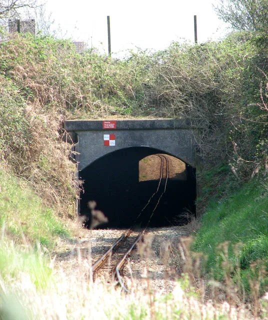
The Wells and Walsingham Light Railway is a 10+1⁄4 in (260 mm) gauge heritage railway in Norfolk, England running between the coastal town of Wells-next-the-Sea and the inland village of Walsingham. The railway occupies a four-mile (6.4 km) section of the trackbed of the former Wymondham to Wells branch which was closed to passengers in stages from 1964 to 1969 as part of the Beeching cuts. Other parts of this line, further south, have also been preserved by the Mid-Norfolk Railway. Despite its miniature dimensions, the Wells and Walsingham Light Railway is a "public railway", indicating that its operation is established by Act of Parliament. The original establishment of the preserved line was authorised by the Wells and Walsingham Light Railway Order 1982, the terms of which were altered under the subsequent Wells and Walsingham Light Railway (Amendment) Order 1994. Prior to 1982 the 15 in (381 mm) gauge Romney, Hythe and Dymchurch Railway had traded as "The World's smallest public railway", a phrase sometimes quoted by the Wells and Walsingham Light Railway since the 1982 Light Railway Order.
Excerpt from Wikipedia under CC BY-SA 4.0. See the source article linked in Sources below.
Background
Description
The line, which is 4 mi long, is now the longest gauge railway in the world. It runs from the coastal town of Wells-next-the-Sea to the village of Walsingham, famous as a centre of pilgrimage to the Shrine of Our Lady of Walsingham. Owing to the difficulty of obtaining authority to operate across main roads via level crossings, the railway operates between a newly built station located on the A149 approximately 1/2 mi south of the original terminus at Wells, and a similar new terminus at Walsingham situated a short distance north of the original GER station, and within sight of it. Trains run daily between March and November, with the timetable intensifying during the high season period.…
Sourced from Wikipedia under CC BY-SA 4.0.
- Coordinates
- 52.9300, 0.8774
- County
- Norfolk
- District
- North Norfolk
- Parish
- Wighton
- Postcode
- NR23 1PS
- Parliamentary constituency
- North Norfolk
- Nearest railway station
- Warham — 0.7 km
Sources
- osm: w1103228843 (ODbL)
- wikipedia: Wells and Walsingham Light Railway (CC BY-SA 4.0)
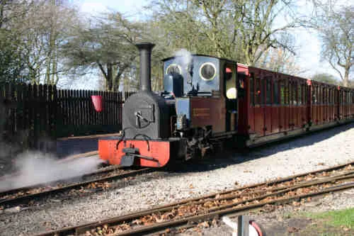
- commons: W&WLR Locomotive at Wells.JPG (CC BY-SA 4.0)
Other places nearby
Loading nearby places…
Nearby
Caravan parks · East Midlands
Grove Farm
Grove Farm — a caravan park in england east midlands.
Caravan parks · East Midlands
Shrublands
Shrublands — a caravan park in england east midlands.
Vineyards · East Midlands
Warham Camp
Warham Camp — a UK vineyard in england east midlands, producing English or Welsh wine from cool-climate grape varieties.
 📷 3
📷 3Archaeological sites · East Midlands
Warham Camp
Warham Camp — a archaeological in england-east-midlands, United Kingdom.
 📷 3
📷 3Memorials & monuments · East Midlands
Wighton War Memorial
Wighton War Memorial — Grade II listed building-listed memorial in england-east-midlands, United Kingdom.
Vineyards · East Midlands
Warham Burrows
Warham Burrows — a UK vineyard in england east midlands, producing English or Welsh wine from cool-climate grape varieties.
More heritage railways in this region
 📷 5
📷 5Heritage railways · East Midlands
Bure Valley Railway
Bure Valley Railway is a heritage railway in the United Kingdom.
 📷 3
📷 3Heritage railways · East Midlands
Butterley Park Minature Railway
Butterley Park Minature Railway is a heritage railway in the United Kingdom.
 📷 3
📷 3Heritage railways · East Midlands
Markeaton Park Light Railway
Markeaton Park Light Railway is a heritage railway in the United Kingdom.
 📷 3
📷 3Heritage railways · East Midlands
Markeaton Park Light Railway
Markeaton Park Light Railway is a heritage railway in the United Kingdom.
Frequently asked questions
- Where is Wells & Walsingham Light Railway?
- Wells & Walsingham Light Railway is in Norfolk, the East Midlands, United Kingdom (postcode NR23 1PS), in the parish of Wighton.
- Is Wells & Walsingham Light Railway a protected site?
- Yes — Wells & Walsingham Light Railway is part of the Norfolk Coast National Landscape (AONB).
- How do I get to Wells & Walsingham Light Railway?
- The nearest railway station is Warham, about 0.7 km away. Drivers can navigate to postcode NR23 1PS.