Natural landmarks · North West England
Ward's Stone
Ward's Stone — mountain in the United Kingdom.

Wikimedia Commons contributors — see linked file page for photographer and licence licence
Plan your visit
- Typical visit
- 1 h–2 h
- Free entry
- Dog-friendly
About
Ward's Stone is a named natural landmark in the United Kingdom. Wikidata describes it as: "mountain in the United Kingdom". Coordinates: 54.0227°, -2.6242°.
Photo gallery
Protected designations
- Site of Special Scientific Interest: Bowland Fells SSSI
- Area of Outstanding Natural Beauty: Forest Of Bowland
Designations sourced from Natural England open data under OGL v3.
From the Wikipedia article
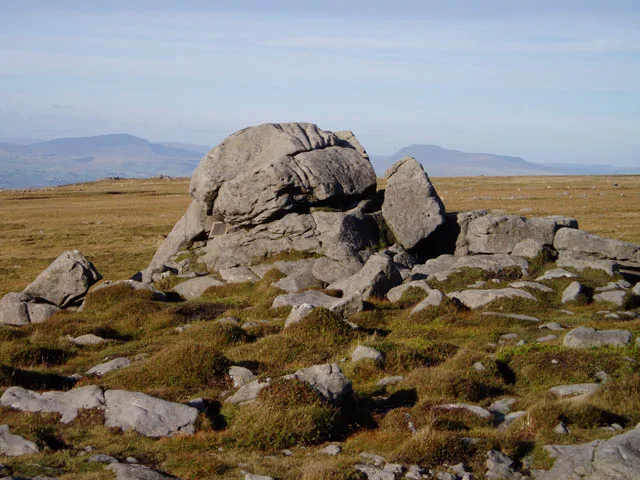
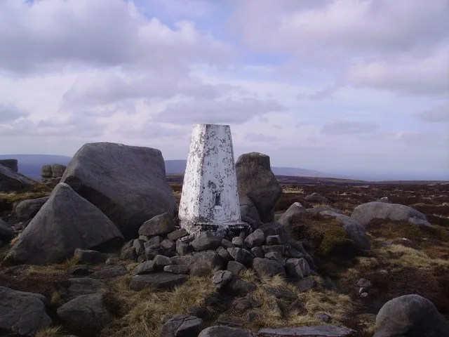
Ward's Stone is the highest hill in the Forest of Bowland, England. Its flat top hides two trig points nearly a kilometre apart. The western trig point sits atop of large rocks, including one, the Ward's Stone, that is so large it attracts boulderers and climbers. The path from Grit Fell is difficult: crossing Cabin Flat, it weaves its way across hidden pools of stagnant water, the presence of which is betrayed by a form of red grass. White markers supposedly point out the way, but more often result in leading the walker astray. The second trig points faces the empty vastness of the eastern Forest of Bowland, with the summits of Wolfhole Crag, White Hill and the distant Ingleborough breaking the horizon. A second path approaches Ward's Stone from Tarnbrook, where limited parking is available. On the southern slope of this hill are Thorn Crag, Hell Crag and Long Crag, rocky outcroppings that are popular with climbers. Within Thorn Crag, a shallow cave system exists that leads to Hell Crag; this route was first traversed by Lancaster University Mountaineering Club.
Excerpt from Wikipedia under CC BY-SA 4.0. See the source article linked in Sources below.
- Coordinates
- 54.0227, -2.6242
- Address
- Lancashire, England
Sources
- wikidata: Q2549111 (CC0)
- wikipedia: Ward's Stone (CC BY-SA 4.0)
- commons: Ward's Stone - geograph.org.uk - 49511.jpg (CC BY-SA 4.0)
Other places nearby
Loading nearby places…
Nearby
 📷 3
📷 3Mountains & hills · North West England
Ward's Stone
Ward's Stone — Named summit at 563 m.
 📷 3
📷 3Memorials & monuments · North West England
BS 1890
BS 1890 — a memorial in england-north-west, United Kingdom.
 📷 3
📷 3Mountains & hills · North West England
Ward's Stone (West)
Ward's Stone (West) — Named summit at 560 m.
 📷 3
📷 3Memorials & monuments · North West England
Anthony Mason Hornby
Anthony Mason Hornby — a memorial in england-north-west, United Kingdom.
 📷 3
📷 3Mountains & hills · North West England
Grit Fell
Grit Fell — Named summit at 467 m.
 📷 3
📷 3Natural landmarks · North West England
Wolfhole Crag
Wolfhole Crag — mountain in the United Kingdom.
More natural landmarks in this region
 ★ Iconic📷 4
Natural landmarks · North West England
Coniston Water
Lake District lake — Swallows and Amazons setting and Donald Campbell water-speed history.
 📷 3
📷 3Natural landmarks · North West England
Elter Water
Elter Water — lake in the United Kingdom.
 📷 3
📷 3Natural landmarks · North West England
Esthwaite Water
Esthwaite Water — lake in the United Kingdom.
 Flagship📷 5
Natural landmarks · North West England
Semerwater
Semerwater — lake in North Yorkshire, England, UK.
Frequently asked questions
- Where is Ward's Stone?
- Ward's Stone is in North-West England, United Kingdom.
- Is Ward's Stone a protected site?
- Yes — Ward's Stone is part of the Bowland Fells SSSI Site of Special Scientific Interest and the Forest Of Bowland National Landscape (AONB).
- Is Ward's Stone free to visit?
- Yes, Ward's Stone is free to enter.