Towns & cities · East Midlands
Walkeringham
Walkeringham — village in Nottinghamshire, England, UK.

JThomas — CC BY-SA 2.0 via Wikimedia Commons licence
%2C_Walkeringham_-_geograph.org.uk_-_4367640.jpg)
Plan your visit
- Typical visit
- 3 h–6 h
- Nearest railway station
- Gainsborough Central · 5.2 km
- Free entry
- Family-friendly
- Dog-friendly
About
Walkeringham is a town, city, village or settlement in the United Kingdom. Recent population estimates put it at around 908 people. Address: DN10. Wikidata describes it as: "village in Nottinghamshire, England, UK". Coordinates: 53.4200°, -0.8400°.
Photo gallery
Protected designations
- Site of Special Scientific Interest: Humber Estuary - 2000480 SSSI
- Ramsar wetland: Humber Estuary
Designations sourced from Natural England open data under OGL v3.
From the Wikipedia article
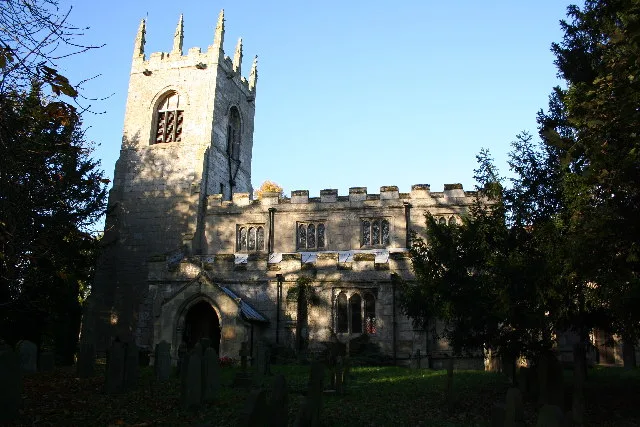
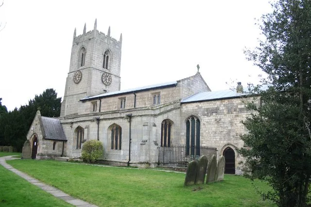
Walkeringham is a village and civil parish in Nottinghamshire, England. According to the 2001 census it had a population of 908, increasing to 1,022 at the 2011 census, and additionally to 1,118 at the 2021 census. The parish church of St Mary Magdalen is 13th century. It has one public house: The Fox and Hounds. Southmoor lodge, employs 29 local people to care for 40 older people. It also has a former station house (now a private residence) and a level crossing across Station Road. The end of Station Road is cut off by the River Trent. Walkeringham's housing was extended in the mid-1960s to accommodate the workers of West Burton Power Station. The village also has a small school, which has recently been extended with a new hall (2010).
Excerpt from Wikipedia under CC BY-SA 4.0. See the source article linked in Sources below.
- Coordinates
- 53.4200, -0.8400
- County
- Nottinghamshire
- District
- Bassetlaw
- Parish
- Walkeringham
- Postcode
- DN10
- Parliamentary constituency
- Bassetlaw
- Population
- 908
- Nearest railway station
- Gainsborough Central — 5.2 km
- Official site
- walkeringham.info
Sources
- wikidata: Q2180614 (CC0)
- wikipedia: Walkeringham (CC BY-SA 4.0)
Other places nearby
Loading nearby places…
Nearby
 📷 3
📷 3Historic churches · East Midlands
St Mary Magdalene's Church, Walkeringham
St Mary Magdalene's Church, Walkeringham — church in Bassetlaw, UK.
 📷 3
📷 3Historic houses · East Midlands
Standing cross on Walkeringham village green
Standing cross on Walkeringham village green — a Grade II*-listed historic house in england-east-midlands, United Kingdom.
 📷 5
📷 5Historic churches · East Midlands
Walkerith
Walkerith — a church in england-east-midlands, United Kingdom.
 📷 3
📷 3Historic churches · East Midlands
All Saints' Church, Beckingham
All Saints' Church, Beckingham — parish church in Beckingham, Nottinghamshire, England, UK.
 📷 3
📷 3Historic bridges · East Midlands
Swallow Bridge, Chesterfield Canal
Swallow Bridge, Chesterfield Canal — Grade II listed building-listed bridge in england-east-midlands, United Kingdom.
 📷 3
📷 3Memorials & monuments · East Midlands
Misterton War Memorial
Misterton War Memorial — Grade II listed building-listed memorial in england-east-midlands, United Kingdom.
More towns in this region
 Flagship📷 3
Towns & cities · East Midlands
Aldborough
Aldborough — village in Norfolk, England, UK.
 Flagship📷 4
Towns & cities · East Midlands
Alderford
Alderford — village and civil parish in Norfolk, UK.
 Flagship📷 5
Towns & cities · East Midlands
Ashmanhaugh
Ashmanhaugh — village in Norfolk, England, UK.
 Flagship📷 3
Towns & cities · East Midlands
Attlebridge
Attlebridge — a village located in Broadland, United Kingdom.
Frequently asked questions
- Where is Walkeringham?
- Walkeringham is in Nottinghamshire, the East Midlands, United Kingdom (postcode DN10), in the parish of Walkeringham.
- Is Walkeringham a protected site?
- Yes — Walkeringham is part of the Humber Estuary - 2000480 SSSI Site of Special Scientific Interest and the Humber Estuary Ramsar wetland.
- Is Walkeringham free to visit?
- Yes, Walkeringham is free to enter.
- How do I get to Walkeringham?
- The nearest railway station is Gainsborough Central, about 5.2 km away. Drivers can navigate to postcode DN10.