Towns & cities · London
Upper Sundon
Upper Sundon — village in Bedfordshire, England, UK.

Wikimedia Commons contributors — see linked file page for photographer and licence licence
Plan your visit
- Typical visit
- 3 h–6 h
- Nearest railway station
- Harlington · 2.8 km
- Free entry
- Family-friendly
- Dog-friendly
About
Upper Sundon is a town, city, village or settlement in the United Kingdom. Address: LU3. Wikidata describes it as: "village in Bedfordshire, England, UK". Coordinates: 51.9383°, -0.4810°.
Photo gallery
Protected designations
- Area of Outstanding Natural Beauty: Chilterns
Designations sourced from Natural England open data under OGL v3.
From the Wikipedia article
Upper Sundon is a village located in the Central Bedfordshire district of Bedfordshire, England. The village is the largest settlement in the wider Sundon civil parish, though Lower Sundon is presumed to be older, as the parish church (first built in the 13th Century) is located there. The manor of Sundon is listed in the Domesday Book of 1086. The manor was held by the de Clare, Badlesmere and Scrope families until the mid 16th century, when it passed to the Cheyne family. In 1716 it was sold to William Clayton, 1st Baron Sundon. It later passed to the Page-Turner family. Today, Upper Sundon houses most of the amenities located in the parish, including Sundon Lower School and a pub. Historically the village contained three pubs but two have since closed leaving The Red Lion as the only public house in Upper Sundon. The village is close to the large town of Luton, and is bordered on the west by the M1 motorway. The village has a Site of Special Scientific Interest, Sundon Chalk Quarry. The Icknield Way Path passes through the village on its 110-mile journey from Ivinghoe Beacon in Buckinghamshire to Knettishall Heath in Suffolk. The Icknield Way Trail, a multi-user route for walkers, horse riders and off-road cyclists also passes near the village.
Excerpt from Wikipedia under CC BY-SA 4.0. See the source article linked in Sources below.
- Coordinates
- 51.9383, -0.4810
- District
- Central Bedfordshire
- Parish
- Sundon
- Postcode
- LU3
- Parliamentary constituency
- Mid Bedfordshire
- Nearest railway station
- Harlington — 2.8 km
Sources
- wikidata: Q1519031 (CC0)
- wikipedia: Upper Sundon (CC BY-SA 4.0)
- commons: The Crown, Upper Sundon - geograph.org.uk - 225652.jpg (CC BY-SA 4.0)
Other places nearby
Loading nearby places…
Nearby
 📷 5
📷 5Historic churches · London
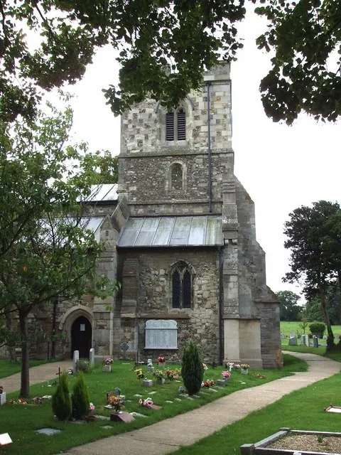
Church of St Mary, Sundon
Church of St Mary, Sundon — church in Sundon, Bedfordshire, England, UK.
 📷 5
📷 5Towns & cities · London
Lower Sundon
Lower Sundon — village in Bedfordshire, England, UK.
 📷 3
📷 3Towns & cities · West Midlands
Chalton
Chalton — village and civil parish in Bedfordshire, UK.
 📷 3
📷 3Wildlife reserves · West Midlands
Fancott Woods and Meadows
Fancott Woods and Meadows — nature reserve in the United Kingdom.
 📷 3
📷 3Miniature railways · West Midlands
Fancott Miniature Railway
Fancott Miniature Railway — a miniature railway in england-west-midlands, United Kingdom.
 📷 3
📷 3Towns & cities · West Midlands
Fancott
Fancott — village in Bedfordshire, United Kingdom.
More towns in this region
 Flagship📷 10
Towns & cities · London
Aldenham
Aldenham — village and civil parish in Hertfordshire, England.
 Flagship📷 10
Towns & cities · London
Ashdon
Ashdon — village and civil parish in Essex, UK.
 Flagship📷 10
Towns & cities · London
Betchworth
Betchworth — village and civil parish in the Mole Valley district of Surrey, England.
 Flagship📷 10
Towns & cities · London
Boxley
Boxley — village and civil parish in Maidstone District, Kent, England, UK.
Frequently asked questions
- Where is Upper Sundon?
- Upper Sundon is in London, United Kingdom (postcode LU3), in the parish of Sundon.
- Is Upper Sundon a protected site?
- Yes — Upper Sundon is part of the Chilterns National Landscape (AONB).
- Is Upper Sundon free to visit?
- Yes, Upper Sundon is free to enter.
- How do I get to Upper Sundon?
- The nearest railway station is Harlington, about 2.8 km away. Drivers can navigate to postcode LU3.