Towns & cities · South East England
Tilmanstone
Tilmanstone — village in Kent, England, UK.

Wikimedia Commons contributors — see linked file page for photographer and licence licence
Plan your visit
- Typical visit
- 3 h–6 h
- Nearest railway station
- Eythorne · 2.8 km
- Free entry
- Family-friendly
- Dog-friendly
About
Tilmanstone is a town, city, village or settlement in the United Kingdom. Recent population estimates put it at around 365 people. Wikidata describes it as: "village in Kent, England, UK". Coordinates: 51.2150°, 1.2950°.
Photo gallery
Protected designations
- Area of Outstanding Natural Beauty: Kent Downs
Designations sourced from Natural England open data under OGL v3.
From the Wikipedia article
Tilmanstone is a small village and civil parish in Kent, in the South East of England, near Eastry, a much bigger and more developed area. Tilmanstone no longer has a village school; however, the independent Northbourne Park School is close to the parish boundary. The name of Tilmanstone has historically been famous for its colliery, although it is located in the village of Eythorne, operated from 1906 to 1986 as one of the four main pits of the Kent coalfield. The population taken at the 2011 Census also included that of the nearby hamlet of Ashley.
Excerpt from Wikipedia under CC BY-SA 4.0. See the source article linked in Sources below.
Background
History
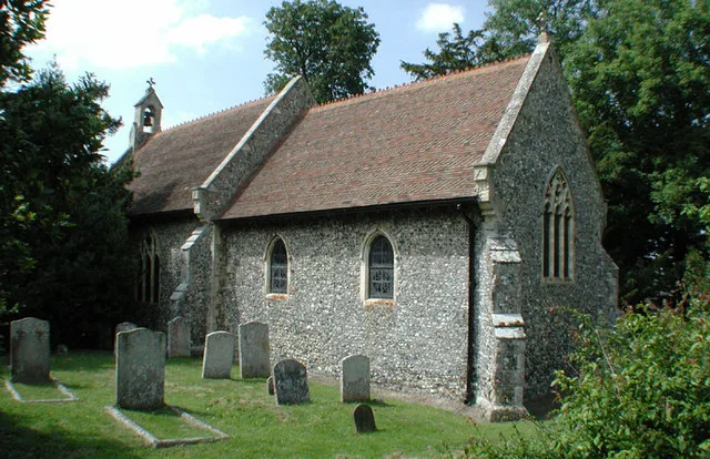
The parish church of St Andrew dates back to the mid-11th century and is made of flint, with later stone and brick sections. The church also includes the Tilmanstone Brass, which recognized Richard Fogge (c. 1482, a descendant of politician Thomas Fogge) and features a point perspective with three-dimensional figures, something that at the time was only popular in Florence. The yew tree in the churchyard has been dated to more than 1,200 years, likely to be older than anything else in the village. The manors of Dane Court, South Court, and North Court form the foundation of the ancient village. The Kent Archaeological Society transcription of 1922 included the North Court and South Court…
Sourced from Wikipedia under CC BY-SA 4.0.
- Coordinates
- 51.2150, 1.2950
- County
- Kent
- District
- Dover
- Parish
- Tilmanstone
- Postcode
- CT14 0JH
- Parliamentary constituency
- Dover and Deal
- Population
- 365
- Nearest railway station
- Eythorne — 2.8 km
- Official site
- www.neighbourhood.statistics.gov.uk
Sources
- wikidata: Q745557 (CC0)
- wikipedia: Tilmanstone (CC BY-SA 4.0)
- commons: Plough & Harrow public house, Tilmanstone.jpg (CC BY-SA 4.0)
Other places nearby
Loading nearby places…
Nearby
 📷 5
📷 5Memorials & monuments · South East England
Tilmanstone War Memorial
Tilmanstone War Memorial — Grade II listed building-listed memorial in england-south-east, United Kingdom.
 📷 5
📷 5Historic churches · South East England
Church of St Andrew
Church of St Andrew — church in Tilmanstone, Kent, England, UK.
Campsites · South East England
Betteshanger Scout Camp Site
Betteshanger Scout Camp Site — a campsite in england south east.
 📷 5
📷 5Natural landmarks · South East England
Eythorne
Eythorne — a other in england-south-east, United Kingdom.
 📷 5
📷 5Memorials & monuments · South East England
Monument To Sayer Family About 25 Metres South West Of Church Of St Peter And St Paul
Monument To Sayer Family About 25 Metres South West Of Church Of St Peter And St Paul — Grade II listed building-listed memorial in england-south-east, United Kingdom.
 📷 5
📷 5Historic churches · South East England
St Clement's Church, Knowlton
St Clement's Church, Knowlton — church in Knowlton, Kent, England, UK.
More towns in this region
 Flagship📷 10
Towns & cities · South East England
Aldermaston
Aldermaston — village and civil parish in West Berkshire in England, UK.
 Flagship📷 10
Towns & cities · South East England
Aldingbourne
Aldingbourne — village and civil parish in Arun, West Sussex, UK.
 Flagship📷 10
Towns & cities · South East England
Aldington
Aldington — village and civil parish in the Ashford District of Kent, England.
 Flagship📷 10
Towns & cities · South East England
Aldworth
Aldworth — village and civil parish in the English county of Berkshire.
Frequently asked questions
- Where is Tilmanstone?
- Tilmanstone is in Kent, South-East England, United Kingdom (postcode CT14 0JH), in the parish of Tilmanstone.
- Is Tilmanstone a protected site?
- Yes — Tilmanstone is part of the Kent Downs National Landscape (AONB).
- Is Tilmanstone free to visit?
- Yes, Tilmanstone is free to enter.
- How do I get to Tilmanstone?
- The nearest railway station is Eythorne, about 2.8 km away. Drivers can navigate to postcode CT14 0JH.