Reservoirs & lochs · Yorkshire & the Humber
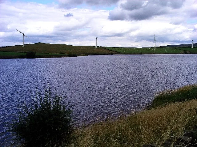
Thornton Steward Reservoir
Thornton Steward Reservoir — reservoir in North Yorkshire, England, UK.

Wikimedia Commons contributors — see linked file page for photographer and licence licence
Plan your visit
- Typical visit
- 1 h–2.5 h
- Nearest railway station
- Finghall Lane · 2.0 km
- Free entry
- Dog-friendly
About
Thornton Steward Reservoir is a reservoir in the United Kingdom. Wikidata describes it as: "reservoir in North Yorkshire, England, UK". Coordinates: 54.2881°, -1.7228°.
Photo gallery
From the Wikipedia article
Thornton Steward Reservoir is a reservoir north of the village of Thornton Steward in North Yorkshire, England. It is owned by Yorkshire Water, and supplies drinking water to Swaledale, Wensleydale, Northallerton, and Thirsk. Thornton Steward Water Treatment Works (WTW) opened in 1977, and was refurbished in the 1990s. It was upgraded in 2003, and its mains connections improved in 2007, allowing Yorkshire Water to close older works in Langthwaite and at Cod Beck Reservoir above Osmotherley. The removal of the Langthwaite WTW, which was fed with groundwater from an adit, means that Thornton Steward now meets the needs of the Swaledale settlements formerly provided by Langthwaite. The majority of the water from Thornton Steward is piped to a pumping station north of Ainderby Steeple and from there to Bullamoor Reservoir (a system of four covered concrete cisterns on the hillside east of Northallerton). That in turn supplies Northallerton and Thirsk. The reservoir is fed from water pumped from the River Ure, which is extracted at Kilgram Bridge 1 mile (2 km) to the south. It is also supplied with water from Leighton Reservoir. The reservoir is host to the Thornton Steward Sailing Club and is used for fly fishing.
Excerpt from Wikipedia under CC BY-SA 4.0. See the source article linked in Sources below.
- Coordinates
- 54.2881, -1.7228
- District
- North Yorkshire
- Parish
- Thornton Steward
- Postcode
- HG4 4BQ
- Parliamentary constituency
- Richmond and Northallerton
- Nearest railway station
- Finghall Lane — 2 km
Sources
- wikidata: Q7348357 (CC0)
- wikipedia: Thornton Steward Reservoir (CC BY-SA 4.0)
- commons: ThorntonStewardReservoir.JPG (CC BY-SA 4.0)
Other places nearby
Loading nearby places…
Nearby
 📷 5
📷 5Gardens · Yorkshire & the Humber
Fort Horn
Fort Horn — a garden in england-yorkshire, United Kingdom.
Caravan parks · Yorkshire & the Humber
Spruce Gill House
Spruce Gill House — a caravan park in england yorkshire.
 📷 4
📷 4Historic bridges · Yorkshire & the Humber
Kilgram Bridge
Kilgram Bridge — scheduled monument-listed bridge in england-yorkshire, United Kingdom.
Caravan parks · Yorkshire & the Humber
Akebar Park
Akebar Park — a caravan park in england yorkshire.
📷 3Archaeological sites · Yorkshire & the Humber
Kilgram Monastic Grange
Kilgram Monastic Grange — a archaeological in england-yorkshire, United Kingdom.
Vineyards · Yorkshire & the Humber
Unthank
Unthank — a UK vineyard in england yorkshire, producing English or Welsh wine from cool-climate grape varieties.
More places in this region
 Flagship📷 3
Reservoirs & lochs · Yorkshire & the Humber
Chelker Reservoir
Chelker Reservoir — reservoir in North Yorkshire, England, UK.
 Flagship📷 5
Reservoirs & lochs · Yorkshire & the Humber
Cod Beck Reservoir
Cod Beck Reservoir — reservoir in North Yorkshire, England, UK.
 📷 5
📷 5Reservoirs & lochs · Yorkshire & the Humber
Angram Reservoir
Angram Reservoir — reservoir in North Yorkshire, England, UK.
 📷 5
📷 5Reservoirs & lochs · Yorkshire & the Humber
Baitings Reservoir
Baitings Reservoir — reservoir in West Yorkshire, England, UK.
Frequently asked questions
- Where is Thornton Steward Reservoir?
- Thornton Steward Reservoir is in Yorkshire & the Humber, in the United Kingdom — coordinates 54.2881°, -1.7228°. The nearest railway station is Finghall Lane, around 2 km away.
- Is Thornton Steward Reservoir free to visit?
- Yes — admission to Thornton Steward Reservoir is free.