Towns & cities · East Midlands
Sustead
Sustead — village and civil parish in Norfolk, United Kingdom.

Wikimedia Commons contributors — see linked file page for photographer and licence licence
Plan your visit
- Typical visit
- 3 h–6 h
- Nearest railway station
- Roughton Road · 4.9 km
- Free entry
- Family-friendly
- Dog-friendly
About
Sustead is a town, city, village or settlement in the United Kingdom. It covers approximately 7 km². Recent population estimates put it at around 190 people. Wikidata describes it as: "village and civil parish in Norfolk, United Kingdom". Coordinates: 52.8856°, 1.2506°.
Photo gallery
Protected designations
- Area of Outstanding Natural Beauty: Norfolk Coast
Designations sourced from Natural England open data under OGL v3.
From the Wikipedia article
Sustead is a small village and parish in the county of Norfolk, England, about four miles south-west of Cromer. The parish also includes the villages of Bessingham and Metton. The parish is bounded by Aldborough and Hanworth to the south, Roughton to the east, Felbrigg and Aylmerton to the north and Gresham to the west.
Excerpt from Wikipedia under CC BY-SA 4.0. See the source article linked in Sources below.
Background
History
The villages name means 'South place'. Sustead has an entry in the Domesday Book of 1086. Sustead is recorded by the names Surstede and Sutstede. The main land holder was William de Warren and the main tenant was Roger Bigot. The survey also states there were 1½ mills.
Description
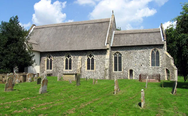
The earliest parts of this church are Saxon but over the years it has been added to and altered by the Normans, Tudors and Victorians. The nave reflects all these periods in its decoration. The north and south doorways date from the 14th century whilst the square headed windows date from the 15th century. There are fragments of mediaeval stained glass in the south window. Behind the pulpit there are the signs of a blocked off, long demolished north transept. There is an octagonal font which dates from the 15th century. The pulpit is from the 17th century and is decorated with heads of angels. The pulpit was originally from the church at North Barningham. The screen dates from the 14th…
Sourced from Wikipedia under CC BY-SA 4.0.
- Coordinates
- 52.8856, 1.2506
- County
- Norfolk
- District
- North Norfolk
- Parish
- Sustead
- Postcode
- NR11 8RU
- Parliamentary constituency
- North Norfolk
- Population
- 190
- Nearest railway station
- Roughton Road — 4.9 km
- Official site
- www.neighbourhood.statistics.gov.uk
Sources
- wikidata: Q39445 (CC0)
- wikipedia: Sustead (CC BY-SA 4.0)
- commons: Metton St. Andrew's church - geograph.org.uk - 5918083.jpg (CC BY-SA 4.0)
Other places nearby
Loading nearby places…
Nearby
 📷 3
📷 3Public art & sculpture · East Midlands
Sustead Village Sign
Sustead Village Sign — a public art in england-east-midlands, United Kingdom.
 📷 3
📷 3Memorials & monuments · East Midlands
Metton War Memorial
Metton War Memorial — Grade II listed building-listed memorial in england-east-midlands, United Kingdom.
 📷 3
📷 3Historic churches · East Midlands
All Saints Church, Thurgarton
All Saints Church, Thurgarton — church in Thurgarton, Norfolk, England, UK.
 📷 4
📷 4Historic houses · East Midlands
Hanworth Hall
Hanworth Hall — a Grade I-listed historic house in england-east-midlands, United Kingdom.
 📷 3
📷 3Natural landmarks · East Midlands
Wizard Maze & Play
Wizard Maze & Play — a other in england-east-midlands, United Kingdom.
 📷 3
📷 3Memorials & monuments · East Midlands
Aylmerton Cross
Aylmerton Cross — a memorial in england-east-midlands, United Kingdom.
More towns in this region
 Flagship📷 3
Towns & cities · East Midlands
Aldborough
Aldborough — village in Norfolk, England, UK.
 Flagship📷 4
Towns & cities · East Midlands
Alderford
Alderford — village and civil parish in Norfolk, UK.
 Flagship📷 5
Towns & cities · East Midlands
Ashmanhaugh
Ashmanhaugh — village in Norfolk, England, UK.
 Flagship📷 3
Towns & cities · East Midlands
Attlebridge
Attlebridge — a village located in Broadland, United Kingdom.
Frequently asked questions
- Where is Sustead?
- Sustead is in Norfolk, the East Midlands, United Kingdom (postcode NR11 8RU), in the parish of Sustead.
- Is Sustead a protected site?
- Yes — Sustead is part of the Norfolk Coast National Landscape (AONB).
- Is Sustead free to visit?
- Yes, Sustead is free to enter.
- How do I get to Sustead?
- The nearest railway station is Roughton Road, about 4.9 km away. Drivers can navigate to postcode NR11 8RU.