Towns & cities · South East England
Sturry
Sturry — village and civil parish in Kent, England, UK.

Wikimedia Commons contributors — see linked file page for photographer and licence licence
Plan your visit
- Typical visit
- 3 h–6 h
- Nearest railway station
- Sturry · 0.3 km
- Free entry
- Family-friendly
- Dog-friendly
About
Sturry is a town, city, village or settlement in the United Kingdom. It covers approximately 13 km². Recent population estimates put it at around 5,502 people. Wikidata describes it as: "village and civil parish in Kent, England, UK". Coordinates: 51.3036°, 1.1211°.
Photo gallery
Protected designations
- Site of Special Scientific Interest: West Blean and Thornden Woods SSSI
- National Nature Reserve: BLEAN WOODS
- Area of Outstanding Natural Beauty: Kent Downs
Designations sourced from Natural England open data under OGL v3.
From the Wikipedia article
Sturry is a village on the Great Stour river situated 3 miles (4.8 km) northeast of Canterbury in Kent. Its large civil parish incorporates several hamlets and, until April 2019, the former mining village of Hersden.
Excerpt from Wikipedia under CC BY-SA 4.0. See the source article linked in Sources below.
Background
History
Human habitation in Sturry is thought to have started around 430,000 years ago, as dated flint implements - namely knives and arrow-tips - show. Other signs of early human activities include a collection of axes and pottery shards from the Bronze Age and more pottery from the Sturry Hill gravel-pits, and a burial-ground near Stonerocks Farm showed that there was an Iron Age settlement of Belgic Celts (who gave Canterbury its pre-Roman name of Durovernum) from the end of the 2nd century BC. All this evidence indicates that human habitation of some kind existed on the north bank of the River Stour, on Sturry's site, for hundreds and thousands of years. When the Romans arrived, they built…
Description
During the Second World War, Sturry was bombed, the greater part of the High Street being destroyed by a parachute mine in 1941 during the Baedeker Blitz, killing 15 people of which seven were children aged 12 and under. One of these was a little girl who had been to the bakers' and whose body was recovered still clutching the bag of buns she had bought. The same aircraft dropped another bomb, but this landed amongst the allotments. In the book Letters to Sturry, it is recorded that on Wednesday 28 August 1940, there were eight separate air-raid warnings and on 'Battle of Britain Day', 15 September 1940, a German Dornier bomber plane (Aircraft 2651, 3rd Staffel, Kampfgeschwader 76),…
Sourced from Wikipedia under CC BY-SA 4.0.
- Coordinates
- 51.3036, 1.1211
- County
- Kent
- District
- Canterbury
- Parish
- Sturry
- Postcode
- CT2 0JU
- Parliamentary constituency
- Herne Bay and Sandwich
- Population
- 5,502
- Nearest railway station
- Sturry — 0.3 km
- Official site
- web.archive.org
Sources
- wikidata: Q2173192 (CC0)
- wikipedia: Sturry (CC BY-SA 4.0)
- commons: High Street, Sturry - geograph.org.uk - 1351242.jpg (CC BY-SA 4.0)
Other places nearby
Loading nearby places…
Nearby
Cafés · South East England
Chapters
Chapters — a café in england south east.
 📷 5
📷 5Historic churches · South East England
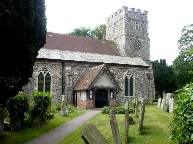
St Nicholas' Church, Sturry
St Nicholas' Church, Sturry — Grade I listed church in Sturry, Canterbury, Kent, England, UK.
 📷 5
📷 5Historic bridges · South East England
Bridge Over The Great Stour
Bridge Over The Great Stour — Grade II listed building-listed bridge in england-south-east, United Kingdom.
 📷 5
📷 5Historic churches · South East England
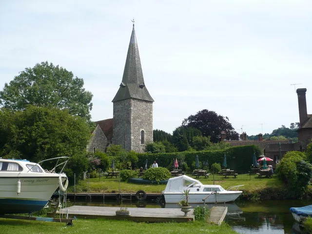
Church of St Mary the Virgin, Fordwich
Church of St Mary the Virgin, Fordwich — Grade I listed church in Fordwich, Canterbury, Kent, England, UK.
 📷 5
📷 5Historic houses · South East England
Watergate Cottage Watergate House
Watergate Cottage Watergate House — house in Fordwich, Canterbury, England, UK.
.jpg?width=1200) 📷 5
📷 5Historic houses · South East England
The Manor House
The Manor House — house in Fordwich, Canterbury, Kent, England, UK.
More towns in this region
 Flagship📷 10
Towns & cities · South East England
Aldermaston
Aldermaston — village and civil parish in West Berkshire in England, UK.
 Flagship📷 10
Towns & cities · South East England
Aldingbourne
Aldingbourne — village and civil parish in Arun, West Sussex, UK.
 Flagship📷 10
Towns & cities · South East England
Aldington
Aldington — village and civil parish in the Ashford District of Kent, England.
 Flagship📷 10
Towns & cities · South East England
Aldworth
Aldworth — village and civil parish in the English county of Berkshire.
Frequently asked questions
- Where is Sturry?
- Sturry is in Kent, South-East England, United Kingdom (postcode CT2 0JU), in the parish of Sturry.
- Is Sturry a protected site?
- Yes — Sturry is part of the West Blean and Thornden Woods SSSI Site of Special Scientific Interest and the BLEAN WOODS National Nature Reserve.
- Is Sturry free to visit?
- Yes, Sturry is free to enter.
- How do I get to Sturry?
- The nearest railway station is Sturry, about 0.3 km away. Drivers can navigate to postcode CT2 0JU.