Towns & cities · East of England
Stoven
Stoven — village in Suffolk, United Kingdom.
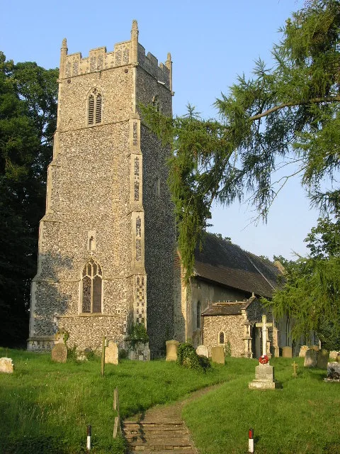
_St_Margaret's_Church_-_geograph.org.uk_-_68600.jpg?width=1200)
Wikimedia Commons contributors — see linked file page for photographer and licence licence
_St_Margaret's_Church_-_geograph.org.uk_-_68600.jpg)
Plan your visit
- Typical visit
- 3 h–6 h
- Nearest railway station
- Brampton · 2.9 km
- Free entry
- Family-friendly
- Dog-friendly
About
Stoven is a town, city, village or settlement in the United Kingdom. Address: NR34. Wikidata describes it as: "village in Suffolk, United Kingdom". Coordinates: 52.3820°, 1.5800°.
Photo gallery
Protected designations
- Area of Outstanding Natural Beauty: Suffolk Coast & Heaths
Designations sourced from Natural England open data under OGL v3.
From the Wikipedia article
Stoven is a village and former civil parish now in the parish of Brampton with Stoven, in the East Suffolk district of the English county of Suffolk. It is located approximately 4.5 miles (7.2 km) north east of Halesworth and 5.5 miles (8.9 km) south of Beccles. In 1961 the parish had a population of 110. On 1 April 1987 the parish was abolished and merged with Brampton to form "Brampton with Stoven" and the population of the expanded parish was 427 at the 2011 United Kingdom census. Brampton is located just to the west, Uggeshall to the south and Sotterley to the north. The parish church is dedicated to St Margaret and is a Grade II* listed building. It was threatened with demolition and sale in the late 1980s and early 1990s before being listed when its medieval structure was revealed. The church re-opened in 1996 and restoration work is believed to be ongoing. Stoven has no services other than the church. Children attend primary school in Brampton and high school in Beccles. The local public house, a 17th-century Grade II listed building, re-opened in July 2008 after having been closed for three and a half years, but closed again in early 2011 and has been converted to residential use.
Excerpt from Wikipedia under CC BY-SA 4.0. See the source article linked in Sources below.
- Coordinates
- 52.3820, 1.5800
- County
- Suffolk
- District
- East Suffolk
- Parish
- Brampton with Stoven
- Postcode
- NR34
- Parliamentary constituency
- Waveney Valley
- Nearest railway station
- Brampton — 2.9 km
Sources
- wikidata: Q671473 (CC0)
- wikipedia: Stoven (CC BY-SA 4.0)
- commons: Stoven (Suffolk) St Margaret's Church - geograph.org.uk - 68600.jpg (CC BY-SA 4.0)
Other places nearby
Loading nearby places…
Nearby
 📷 3
📷 3Historic churches · East of England
Church of St Peter
Church of St Peter — church in Brampton, Suffolk, England, UK.
 📷 3
📷 3Memorials & monuments · East of England
Shadingfield War Memorial
Shadingfield War Memorial — Grade II listed building-listed memorial in england-east, United Kingdom.
 📷 3
📷 3Historic churches · East of England
Church of St John the Baptist
Church of St John the Baptist — Grade I listed church in Shadingfield, Suffolk, England, UK.
 📷 5
📷 5Historic churches · East of England
Church of St Andrew
Church of St Andrew — church in Westhall, Suffolk, England, UK.
Campsites · East of England
Firs Glamping
Firs Glamping — a campsite in england east.
 📷 3
📷 3Historic churches · East of England
Church of St Mary
Church of St Mary — church in Uggeshall, Suffolk, England, UK.
More towns in this region
 Flagship📷 3
Towns & cities · East of England
Alburgh
Alburgh — village and civil parish in Norfolk, UK.
 Flagship📷 3
Towns & cities · East of England
Aldeby
Aldeby — village and civil parish in Norfolk, UK.
 Flagship📷 5
Towns & cities · East of England
Ashill
Ashill — village and civil parish in the English county of Norfolk.
 Flagship📷 3
Towns & cities · East of England
Aslacton
Aslacton — village and civil parish in Norfolk, UK.
Frequently asked questions
- Where is Stoven?
- Stoven is in Suffolk, East of England, United Kingdom (postcode NR34), in the parish of Brampton with Stoven.
- Is Stoven a protected site?
- Yes — Stoven is part of the Suffolk Coast & Heaths National Landscape (AONB).
- Is Stoven free to visit?
- Yes, Stoven is free to enter.
- How do I get to Stoven?
- The nearest railway station is Brampton, about 2.9 km away. Drivers can navigate to postcode NR34.