Historic churches · South East England
St John the Baptist's Church, Clayton
St John the Baptist's Church, Clayton — church in Mid Sussex, England, UK.

Wikimedia Commons contributors — see linked file page for photographer and licence licence
Plan your visit
- Typical visit
- 30 min–1 h
- Nearest railway station
- Hassocks · 1.7 km
- Free entry
About
St John the Baptist's Church, Clayton is a historic church in the United Kingdom. Records date its origin to 1050. Built in the Anglo-Saxon architecture style. Heritage designation: Grade I listed building. Affiliated with Anglicanism. Wikidata describes it as: "church in Mid Sussex, England, UK". Coordinates: 50.9105°, -0.1534°.
Photo gallery
Heritage listing
St John the Baptist's Church is the Church of England parish church of the village of Clayton in Mid Sussex District, one of seven local government districts in the English county of West Sussex. The small and simple Anglo-Saxon building is distinguished by its "remarkable" and extensive set of wall paintings, dating from the early 12th century and rediscovered more than 700 years later. Much of the structural work of the church is 11th-century and has had little alteration. The church, which stands in the middle of a large churchyard and serves the small village of Clayton at the foot of the South Downs, is part of a joint parish with the neighbouring village of Keymer—an arrangement which has existed informally for centuries and which was legally recognised in the 20th century.
From the Historic England List Entry under OGL v3.
Protected designations
- Area of Outstanding Natural Beauty: High Weald
Designations sourced from Natural England open data under OGL v3.
From the Wikipedia article
St John the Baptist's Church is the Church of England parish church of the village of Clayton in Mid Sussex District, one of seven local government districts in the English county of West Sussex. The small and simple Anglo-Saxon building is distinguished by its "remarkable" and extensive set of wall paintings, dating from the early 12th century and rediscovered more than 700 years later. Much of the structural work of the church is 11th-century and has had little alteration. The church, which stands in the middle of a large churchyard and serves the small village of Clayton at the foot of the South Downs, is part of a joint parish with the neighbouring village of Keymer—an arrangement which has existed informally for centuries and which was legally recognised in the 20th century. English Heritage has listed the church at Grade I for its architectural and historical importance.
Excerpt from Wikipedia under CC BY-SA 4.0. See the source article linked in Sources below.
Background
History
The ancient village of Clayton, situated where the main route from London to Brighton crossed an east–west track at the foot of the South Downs, existed at the time of the Domesday survey in 1086, when it was called Claitune or Claitona. It was at the southern end of the parish of the same name, which covered 1414 acre of mostly rural land running north (and downhill) from the summit of the South Downs. The manor of Clayton was held at that time by William de Watevile for William de Warenne, who built the nearby Lewes Castle. The church was in the possession of Lewes Priory, which had been given it by de Warenne in 1093. The original dedication of St John the Baptist's Church was All…
Architecture
St John the Baptist's Church is a typical example of the simple two-cell (nave and chancel) layout found at many pre-Norman Conquest churches in Sussex. and the three 10 in moulded shafts on each side. The jambs terminate in bulky chamfered imposts. The chancel, renewed in the 19th century, measures 19.5 x. The east window is a three-light lancet with mullions, set below a segmental-arched hood mould. There are two narrow lancets in the south and north walls as well, and a blocked window of Anglo-Saxon origin on the latter. The walls are just over 2 ft thick. The nave formerly had a pair of porticus-style side chapels, but little trace of these remains—although blocked windows and fragments…
Description
is one of two others in the parish.]] St John the Baptist's Church was listed at Grade I by English Heritage on 28 October 1957. Such buildings are defined as being of "exceptional interest" and greater than national importance. As of February 2001, it was one of 16 Grade I listed buildings, and 1,028 listed buildings of all grades, in the district of Mid Sussex. The ecclesiastical parish of Clayton with Keymer covers three villages, each with one Church of England parish church, and surrounding rural areas towards Burgess Hill, Ditchling and Hurstpierpoint. Keymer is served by St Cosmas and St Damian Church, which also has Anglo-Saxon origins but was rebuilt in 1866. Hassocks, now linked…
Sourced from Wikipedia under CC BY-SA 4.0.
- Coordinates
- 50.9105, -0.1534
- County
- West Sussex
- District
- Mid Sussex
- Parish
- Hassocks
- Postcode
- BN6 9PQ
- Parliamentary constituency
- Mid Sussex
- Established
- 1050
- Nearest railway station
- Hassocks — 1.7 km
Sources
- wikidata: Q7593716 (CC0)
- wikipedia: St John the Baptist's Church, Clayton (CC BY-SA 4.0)
- commons: St John the Baptist's Church, Clayton, West Sussex - Exterior from Northeast.JPG (CC BY-SA 4.0)
Other places nearby
Loading nearby places…
Nearby
 📷 5
📷 5Museums · South East England
Clayton, West Sussex
Clayton is a small village and former civil parish, now in the parish of Hassocks, in the Mid Sussex district, in the county of West Sussex, England. It lies at the foot of the South Downs, 41 miles (
 📷 5
📷 5Manor houses · South East England
Clayton Manor
Clayton Manor — Grade II listed building-listed manor in england-south-east, United Kingdom.
📷 5Castles · South East England
Clayton Castle
Clayton Castle — Grade II listed building-listed castle in england-south-east, United Kingdom.
 📷 5
📷 5Windmills · South East England
Jill Windmill
Jill Windmill is a windmill in the United Kingdom.
 📷 5
📷 5Windmills · South East England
Clayton Windmills
The Clayton Windmills, known locally as Jack and Jill, stand on the South Downs above the village of Clayton, West Sussex, England. They comprise a post mill and a tower mill, and the roundhouse of a
 📷 5
📷 5Windmills · South East England
Jack Windmill
Jack Windmill is a windmill in the United Kingdom.
Other places from this era
 📷 5
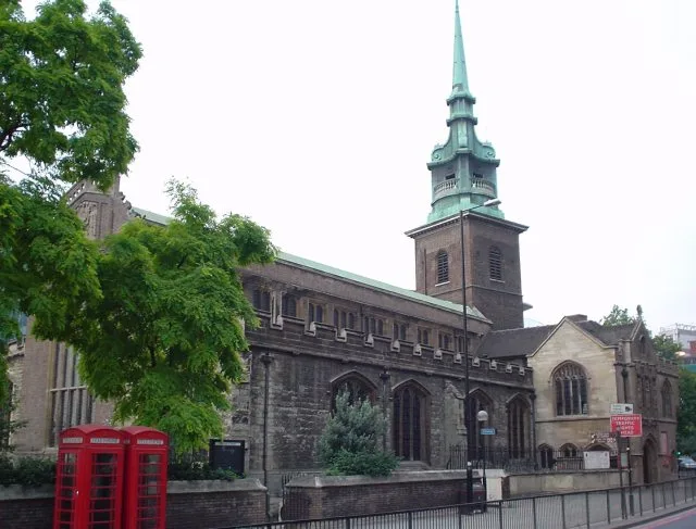
📷 5Historic churches · London
All Hallows-by-the-Tower
All Hallows-by-the-Tower — church in the City of London, United Kingdom.
 📷 5
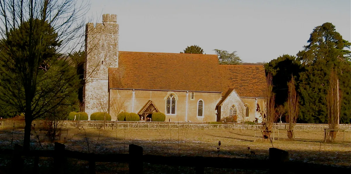
📷 5Historic churches · London
All Saints Church, West Farleigh
All Saints Church, West Farleigh — Grade I listed church in West Farleigh, Maidstone, Kent, England, UK.
 📷 5
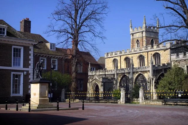
📷 5Historic churches · London
All Saints' Church, Huntingdon
All Saints' Church, Huntingdon — Grade I listed church in Huntingdonshire, United Kingdom.
 📷 5
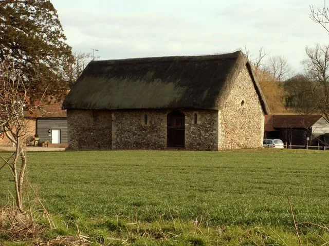
📷 5Historic churches · London
Chapel of St Helen, Wicken Bonhunt
Chapel of St Helen, Wicken Bonhunt — church building in Wicken Bonhunt, Uttlesford, Essex, England, UK.
More places in this region
 Flagship📷 10
Historic churches · South East England
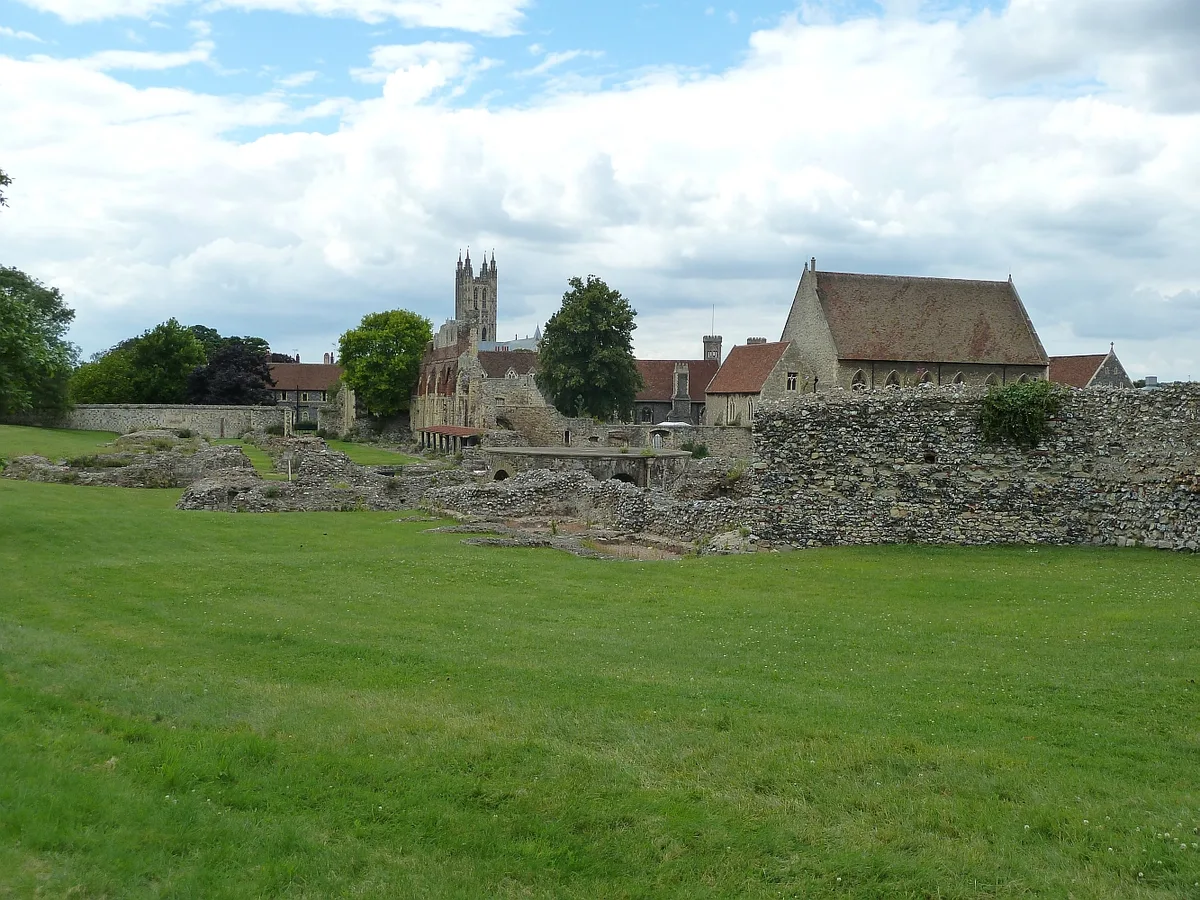
St Augustine's Abbey
St Augustine's Abbey — monastery in Canterbury, Kent, England, UK.
 📷 5
📷 5Historic churches · South East England
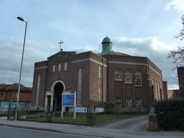
286
286 — church building in Swaythling, Southampton, England.
 📷 5
📷 5Historic churches · South East England
Abbey Church of St Gregory the Great, Downside Abbey
Abbey Church of St Gregory the Great, Downside Abbey — church in Stratton-on-the-Fosse, Somerset, England, UK.
 📷 5
📷 5Historic churches · South East England
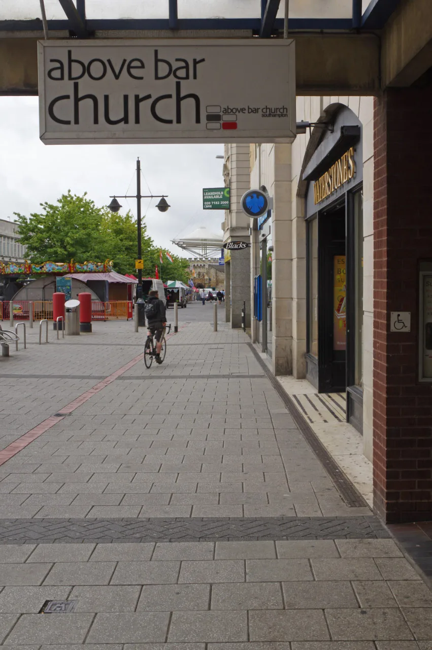
Above Bar Church, Southampton
Above Bar Church, Southampton — church in Southampton, UK.
Frequently asked questions
- Where is St John the Baptist's Church, Clayton?
- St John the Baptist's Church, Clayton is in West Sussex, South-East England, United Kingdom (postcode BN6 9PQ), in the parish of Hassocks.
- When was St John the Baptist's Church, Clayton built?
- Built or established in 1050.
- Is St John the Baptist's Church, Clayton a listed building?
- St John the Baptist's Church, Clayton is officially recognised as Grade I listed building listed.
- Is St John the Baptist's Church, Clayton a protected site?
- Yes — St John the Baptist's Church, Clayton is part of the High Weald National Landscape (AONB).
- Is St John the Baptist's Church, Clayton free to visit?
- Yes, St John the Baptist's Church, Clayton is free to enter.
- How do I get to St John the Baptist's Church, Clayton?
- The nearest railway station is Hassocks, about 1.7 km away. Drivers can navigate to postcode BN6 9PQ.