Towns & cities · East Midlands
Sproxton
Also known as: Sproxton, Swydd Gaerlŷr
Sproxton — village and civil parish in Leicestershire, UK.

Wikimedia Commons contributors — see linked file page for photographer and licence licence
Plan your visit
- Typical visit
- 3 h–6 h
- Nearest railway station
- Central Station · 7.7 km
- Free entry
- Family-friendly
- Dog-friendly
About
Sproxton is a town, city, village or settlement in the United Kingdom. Recent population estimates put it at around 544 people. Address: LE14. Wikidata describes it as: "village and civil parish in Leicestershire, UK". Coordinates: 52.8114°, -0.7306°.
Photo gallery
From the Wikipedia article
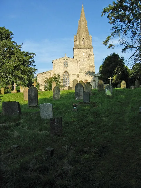
Sproxton () is a village and civil parish within the Borough of Melton in Leicestershire, England, close to the border with Lincolnshire. It has approximately 80 occupied dwellings (2021) and a population of 480, rising to 658 (including Coston, Saltby and Stonesby) at the 2011 census. The village and civil parish are not coterminous; the parish includes the villages of Sproxton, Saltby, Stonesby, Bescaby, and the former RAF Saltby. The River Eye runs through the parish. Nearby places are Waltham on the Wolds, Croxton Kerrial, Coston, Buckminster, and Skillington (in Lincolnshire). The Viking Way runs close by. Nearby is Sproxton Quarry Site of Special Scientific Interest. The 14th-century parish church of St Bartholomew, extended and restored in 1882 by architect Henry Woodyer, is a Grade II* listed building. There is evidence of Norman building in the west wall of the south aisle and the tower is 13th-century. The top part of the tower was rebuilt in the restoration of 1882. There is a Saxon cross in the churchyard - the only complete one in Leicestershire. A post mill stood at Sproxton. The mill was rebuilt in 1889 after it blew down and killed the miller. Wakes & Lamb of Newark rebuilt the mill using materials from the old mill and from one at Castle Bytham. It was wrecked by the gales of March 1916, but repaired. By 1920 it was out of use and was demolished in 1949 when owned by Mr T.A.Mount.
Excerpt from Wikipedia under CC BY-SA 4.0. See the source article linked in Sources below.
- Coordinates
- 52.8114, -0.7306
- County
- Leicestershire
- District
- Melton
- Parish
- Sproxton
- Postcode
- LE14
- Parliamentary constituency
- Melton and Syston
- Population
- 544
- Nearest railway station
- Central Station — 7.7 km
Sources
- wikidata: Q1862125 (CC0)
- wikipedia: Sproxton, Leicestershire (CC BY-SA 4.0)
- commons: The old school, Sproxton - geograph.org.uk - 700813.jpg (CC BY-SA 4.0)
Other places nearby
Loading nearby places…
Nearby
 📷 3
📷 3Historic churches · East Midlands
Church of St Andrew
Church of St Andrew — chirch in Coston, Leicestershire, England, UK.
 📷 3
📷 3Historic churches · East Midlands
Church of St John the Baptist
Church of St John the Baptist — church in Buckminster, Leicestershire, England, UK.
 📷 3
📷 3Memorials & monuments · East Midlands
Sewstern War Memorial
Sewstern War Memorial — Grade II listed building-listed memorial in england-east-midlands, United Kingdom.
 📷 5
📷 5Castles · East Midlands
Garthorpe, Leicestershire
Garthorpe is a village and civil parish (sometimes called Garthorpe and Coston) in Leicestershire, England, in the Melton district. It is about five miles east of Melton Mowbray. The parish includes t
 📷 5
📷 5Historic churches · East Midlands
St Mary's Church, Garthorpe
St Mary's Church, Garthorpe — Grade I listed church in Garthorpe, Melton, Leicestershire, England, UK.
 ★ Iconic📷 3
Cathedrals · East Midlands
Croxton Abbey and associated remains
Croxton Abbey and associated remains is a cathedral in the United Kingdom.
More towns in this region
 Flagship📷 3
Towns & cities · East Midlands
Aldborough
Aldborough — village in Norfolk, England, UK.
 Flagship📷 4
Towns & cities · East Midlands
Alderford
Alderford — village and civil parish in Norfolk, UK.
 Flagship📷 5
Towns & cities · East Midlands
Ashmanhaugh
Ashmanhaugh — village in Norfolk, England, UK.
 Flagship📷 3
Towns & cities · East Midlands
Attlebridge
Attlebridge — a village located in Broadland, United Kingdom.
Frequently asked questions
- Where is Sproxton?
- Sproxton is in Leicestershire, the East Midlands, United Kingdom (postcode LE14), in the parish of Sproxton.
- Is Sproxton free to visit?
- Yes, Sproxton is free to enter.
- How do I get to Sproxton?
- The nearest railway station is Central Station, about 7.7 km away. Drivers can navigate to postcode LE14.