Forests & woodlands · East of England
Skipper's Island
Skipper's Island is a forest or woodland in the United Kingdom.

Wikimedia Commons contributors — see linked file page for photographer and licence licence
Plan your visit
- Typical visit
- 1 h–3 h
- Nearest railway station
- Kirby Cross · 3.8 km
- Free entry
- Family-friendly
- Dog-friendly
About
Skipper's Island is a named forest, woodland or nature reserve in the United Kingdom. Coordinates: 51.8754°, 1.2156°. This entry is part of The Great Britain Guide, a free, ad-free, open-data tourist directory.
Photo gallery
Protected designations
- Site of Special Scientific Interest: Hamford Water SSSI
- National Nature Reserve: HAMFORD WATER
- Ramsar wetland: Hamford Water
Designations sourced from Natural England open data under OGL v3.
From the Wikipedia article
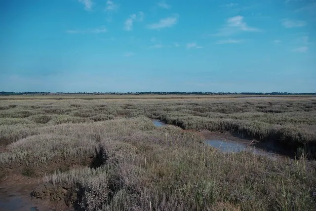
Skipper's Island is a 94.3-hectare (233-acre) nature reserve north of Kirby-le-Soken in Essex, England. It is owned and managed by the Essex Wildlife Trust. The highest part of the island has thorn thickets, separated by grassy rides. The lowest land is saltmarsh, and there is also extensive rough pasture with brackish pools. Flora include sea hog's fennel and lax-flowered sea-lavender, and there are breeding birds such as shelducks and oystercatchers. The island is connected to the mainland by two causeways, and access is only by prior arrangement with the trust.
Excerpt from Wikipedia under CC BY-SA 4.0. See the source article linked in Sources below.
- Coordinates
- 51.8754, 1.2156
- County
- Essex
- District
- Tendring
- Parish
- Thorpe-le-Soken
- Postcode
- CO16 0NL
- Parliamentary constituency
- Clacton
- Nearest railway station
- Kirby Cross — 3.8 km
Sources
- osm: r962470 (ODbL)
- wikipedia: Skipper's Island (CC BY-SA 4.0)
- commons: Saltmarsh On Skippers Island - geograph.org.uk - 1443771.jpg (CC BY-SA 4.0)
Other places nearby
Loading nearby places…
Nearby
 Flagship📷 5
Wildlife reserves · East of England
Skipper's Island
Skipper's Island — island off the coast of Essex.
 📷 3
📷 3Memorials & monuments · East of England
World War II bombing decoy HA2 Kirby-le-Soken
World War II bombing decoy HA2 Kirby-le-Soken is a memorial in the United Kingdom.
 📷 2
📷 2Islands · East of England
Horsey Island
Horsey Island — island in Essex, England.
 📷 3
📷 3Distilleries · East of England
East Coast Distillery
East Coast Distillery — Whisky/spirit distillery.
 📷 3
📷 3Canals · East of England
Beaumont Cut
Beaumont Cut — canal closed in the 1930s.
 📷 3
📷 3Memorials & monuments · East of England
Kirby Le Soken War Memorial
Kirby Le Soken War Memorial — a memorial in england-east, United Kingdom.
More forests in this region
 📷 3
📷 3Forests & woodlands · East of England
Betty's Fen
Betty's Fen is a forest or woodland in the United Kingdom.
 📷 3
📷 3Forests & woodlands · East of England
Bowthorpe Marsh
Bowthorpe Marsh is a forest or woodland in the United Kingdom.
 📷 4
📷 4Forests & woodlands · East of England
Bradfield Woods National Nature Reserve
Bradfield Woods National Nature Reserve is a forest or woodland in the United Kingdom.
 📷 5
📷 5Forests & woodlands · East of England
Captain's Wood Nature Reserve
Captain's Wood Nature Reserve is a forest or woodland in the United Kingdom.
Frequently asked questions
- Where is Skipper's Island?
- Skipper's Island is in Essex, East of England, United Kingdom (postcode CO16 0NL), in the parish of Thorpe-le-Soken.
- Who owns Skipper's Island?
- Skipper's Island is owned by Essex Wildlife Trust.
- Is Skipper's Island a protected site?
- Yes — Skipper's Island is part of the Hamford Water SSSI Site of Special Scientific Interest and the HAMFORD WATER National Nature Reserve.
- Is Skipper's Island free to visit?
- Yes, Skipper's Island is free to enter.
- How do I get to Skipper's Island?
- The nearest railway station is Kirby Cross, about 3.8 km away. Drivers can navigate to postcode CO16 0NL.