Mountains & hills · South West England
Shovel Down
Shovel Down — Named summit at 433 m.

Wikimedia Commons contributors — see linked file page for photographer and licence licence
Plan your visit
- Typical visit
- 3 h–8 h
- Best time of year
- Late spring – early autumn (May–Oct)
- Free entry
- Dog-friendly
About
Shovel Down is a named summit in the United Kingdom. Wikidata describes it as: "Named summit at 433 m.". Coordinates: 50.6560°, -3.9000°.
Photo gallery
Protected designations
- Site of Special Scientific Interest: North Dartmoor SSSI
Designations sourced from Natural England open data under OGL v3.
From the Wikipedia article
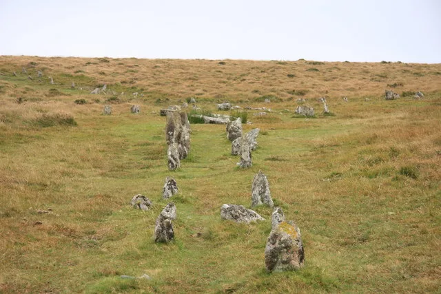
Shovel Down is an area of Dartmoor in Devon that is covered in megaliths including the remains of several stone rows, the Fourfold Stone Circle, and several standing stones.
Excerpt from Wikipedia under CC BY-SA 4.0. See the source article linked in Sources below.
Background
Description
The Long Stone () stands in the middle of two stone rows. It is referred to as the "Langstone" in a documentary source of 1240. It now marks the boundary of three parishes.
Sourced from Wikipedia under CC BY-SA 4.0.
- Coordinates
- 50.6560, -3.9000
- County
- Devon
- District
- West Devon
- Parish
- Gidleigh
- Postcode
- TQ13 8EU
- Parliamentary constituency
- Central Devon
Sources
- osm: n330282686 (ODbL)
- wikipedia: Shovel Down (CC BY-SA 4.0)
- commons: Shovel Down Stone Row - geograph.org.uk - 1513000.jpg (CC BY-SA 4.0)
Other places nearby
Loading nearby places…
Nearby
 📷 3
📷 3Hill forts · South West England
Shovel Down
Shovel Down is a hill fort in the United Kingdom.
 📷 3
📷 3Memorials & monuments · South West England
Shovel Down Stone
Shovel Down Stone — a memorial in england-south-west, United Kingdom.
📷 3Stone circles · South West England
Stone Rows
Stone Rows — a stone circle in england-south-west, United Kingdom.
 📷 3
📷 3Archaeological sites · South West England
Three Boys
Three Boys — a archaeological in england-south-west, United Kingdom.
 📷 3
📷 3Burial mounds & barrows · South West England
Stonetor Hill Cairn Circle
Stonetor Hill Cairn Circle — a burial mound in england-south-west, United Kingdom.
 📷 3
📷 3Natural landmarks · South West England
Kes Tor Round Pound
Kes Tor Round Pound — a natural landmark in england-south-west, United Kingdom.
More mountains in this region
 📷 5
📷 5Mountains & hills · South West England
Alex Tor
Alex Tor — Named summit at 291 m.
 📷 5
📷 5Mountains & hills · South West England
Ash Hole Cavern
Ash Hole Cavern — cave in Brixham, Devon, England, UK.
 📷 5
📷 5Mountains & hills · South West England
Babbacombe Bay
Babbacombe Bay — bay in Devon, England.
 📷 5
📷 5Mountains & hills · South West England
Barley Bay
Barley Bay — bay in the United Kingdom.
Frequently asked questions
- Where is Shovel Down?
- Shovel Down is in Devon, South-West England, United Kingdom (postcode TQ13 8EU), in the parish of Gidleigh.
- Is Shovel Down a protected site?
- Yes — Shovel Down is part of the North Dartmoor SSSI Site of Special Scientific Interest.
- Is Shovel Down free to visit?
- Yes, Shovel Down is free to enter.
- How do I get to Shovel Down?
- Drivers can navigate to postcode TQ13 8EU. It sits within the Central Devon parliamentary constituency.