Mountains & hills · Scottish Lowlands
Shillhope Law
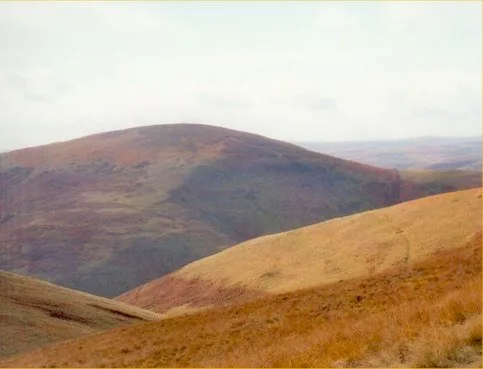
Shillhope Law — Named summit at 501 m.

Wikimedia Commons contributors — see linked file page for photographer and licence licence
Plan your visit
- Typical visit
- 3 h–8 h
- Best time of year
- Late spring – early autumn (May–Oct)
- Free entry
- Dog-friendly
About
Shillhope Law is a named summit in the United Kingdom. Wikidata describes it as: "Named summit at 501 m.". Coordinates: 55.3808°, -2.2016°.
Photo gallery
Protected designations
- Site of Special Scientific Interest: River Coquet and Coquet Valley Woodlands SSSI
Designations sourced from Natural England open data under OGL v3.
From the Wikipedia article
Shillhope Law is a hill in the southern Cheviots, a range of hills in Northumberland, England. Shillhope Law is a relatively unremarkable member of this group; in common with its neighbours it has a small summit and steep, grassy sides falling to deeply incised valleys on either side. However, unlike its neighbours, the ridge connecting Shillhope Law to the higher dome of The Cheviot to the north is bisected by a low col at 343 metres (1,125 ft) m, giving it enough relative height to be a Marilyn. It has an elevation of 501 m (1,644 ft) and a prominence of 158 m (518 ft). The narrow road that climbs up Coquetdale from Alwinton to the foot of Shillhope Law eases any access problems. On the other side of the valley lies the Otterburn Training Area and training (without live ammunition) can take place on the northern side of Shillhope Law. Shillhope Law can be easily climbed from the farms on its western side, Barrowburn and Shillmoor, although the ascent is steep. These two climbs can be combined to give a circular walk of about 5 miles (8.0 km). The view is not far-reaching in any direction because numerous hills and ridges of the same height or higher in all directions except south and south-east.
Excerpt from Wikipedia under CC BY-SA 4.0. See the source article linked in Sources below.
- Coordinates
- 55.3808, -2.2016
- District
- Northumberland
- Parish
- Alwinton
- Postcode
- NE65 7BZ
- Parliamentary constituency
- North Northumberland
Sources
- osm: n471580381 (ODbL)
- wikipedia: Shillhope Law (CC BY-SA 4.0)
- commons: Shillhope Law.jpg (CC BY-SA 4.0)
Other places nearby
Loading nearby places…
Nearby
 📷 3
📷 3Natural landmarks · Scottish Lowlands
Shillhope Law
Shillhope Law — mountain in United Kingdom.
 📷 3
📷 3Natural landmarks · Scottish Lowlands
Wedder Leap Picnic Area
Wedder Leap Picnic Area — a other in scotland-lowlands, United Kingdom.
📷 4Historic bridges · North East England
Barrow Burn
Barrow Burn in England North East, United Kingdom.
 📷 3
📷 3Wildlife reserves · North East England
Barrow Burn Meadows
Barrow Burn Meadows in England North East, United Kingdom.
 📷 5
📷 5National parks · North East England
Usway Burn
Usway Burn in England North East, United Kingdom.
 📷 3
📷 3Archaeological sites · Scottish Lowlands
old Linbrig Village
old Linbrig Village — a archaeological in scotland-lowlands, United Kingdom.
More mountains in this region
 📷 3
📷 3Mountains & hills · Scottish Lowlands
Andrewhinney Hill
Andrewhinney Hill — Named summit at 677 m.
 📷 3
📷 3Mountains & hills · Scottish Lowlands
Arbory Hill
Arbory Hill — Named summit at 429 m.
 📷 3
📷 3Mountains & hills · Scottish Lowlands
Auchenton Hill ( East Mount Lowther)
Auchenton Hill ( East Mount Lowther) — Named summit at 631 m.
 📷 3
📷 3Mountains & hills · Scottish Lowlands
Bakestall
Bakestall — Named summit at 673.5 m.
Frequently asked questions
- Where is Shillhope Law?
- Shillhope Law is in the Scottish Lowlands, United Kingdom (postcode NE65 7BZ), in the parish of Alwinton.
- Is Shillhope Law a protected site?
- Yes — Shillhope Law is part of the River Coquet and Coquet Valley Woodlands SSSI Site of Special Scientific Interest.
- Is Shillhope Law free to visit?
- Yes, Shillhope Law is free to enter.
- How do I get to Shillhope Law?
- Drivers can navigate to postcode NE65 7BZ. It sits within the North Northumberland parliamentary constituency.