Natural landmarks · Scottish Highlands
Sgùrr na Cìche
Also known as: Sgurr na Ciche, Sgùrr na Cìche (Cnòideart)
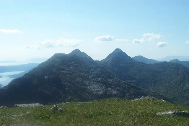
Sgùrr na Cìche — 1040m high mountain in Highland, Scotland, UK.

Wikimedia Commons contributors — see linked file page for photographer and licence licence
Plan your visit
- Typical visit
- 1 h–2 h
- Free entry
- Dog-friendly
About
Sgùrr na Cìche is a named natural landmark in the United Kingdom. Part of Knoydart. Wikidata describes it as: "1040m high mountain in Highland, Scotland, UK". Coordinates: 57.0127°, -5.4572°.
Photo gallery
From the Wikipedia article
Sgùrr na Cìche (Scottish Gaelic for ''pap' or 'conical hilltop'') is a mountain in Knoydart, in the Northwest Highlands of Scotland. It lies on the edge of Knoydart in an area known as the Rough Bounds of Knoydart. The peak has a distinctive conical summit, making it easily recognisable in views from many of Scotland's mountains, including Càrn Eige and Ben Nevis. Its close neighbours include Ladhar Bheinn and The Saddle, but thanks to the deep gulf separating it from them, it has a high prominence — the 25th highest in Britain. Sgùrr na Cìche may be climbed from the head of Loch Nevis on the southern side of Knoydart by following the ridge of Druim a' Ghoirtein. However, due to the remoteness of the Knoydart peninsula, it is more commonly climbed as part of a circuit from the head of Glen Dessarry, via a route that also takes in the neighbouring Munros of Garbh Chioch Mhòr and Sgùrr nan Coireachan. It is also the wettest place in the United Kingdom, with a yearly rainfall average of 5,000 millimetres (200 in).
Excerpt from Wikipedia under CC BY-SA 4.0. See the source article linked in Sources below.
- Coordinates
- 57.0127, -5.4572
- Address
- Knoydart, Scotland
- Official site
- www.walkhighlands.co.uk
Sources
- wikidata: Q3481115 (CC0)
- wikipedia: Sgùrr na Cìche (CC BY-SA 4.0)
- commons: Sgurr na Ciche.jpg (CC BY-SA 4.0)
Other places nearby
Loading nearby places…
Nearby
 📷 5
📷 5Mountains & hills · Scottish Highlands
Sgùrr na Cìche
Sgùrr na Cìche — Named summit at 1040 m.
 📷 3
📷 3Mountains & hills · Scottish Highlands
Druim a' Ghoirtein
Druim a' Ghoirtein — a mountain in scotland-highlands, United Kingdom.
 📷 3
📷 3Mountains & hills · Scottish Highlands
Garbh Chìoch Mhòr
Garbh Chìoch Mhòr — Named summit at 1013 m.
 📷 3
📷 3Mountains & hills · Scottish Highlands
Beinn an Aodainn East Top
Beinn an Aodainn East Top — a mountain in scotland-highlands, United Kingdom.
 📷 3
📷 3Mountains & hills · Scottish Highlands
Garbh Chioch Mhor - Garbh Chioch Bheag
Garbh Chioch Mhor - Garbh Chioch Bheag — a mountain in scotland-highlands, United Kingdom.
 📷 3
📷 3Mountains & hills · Scottish Highlands
Ben Aden
Ben Aden — Named summit at 887 m.
More natural landmarks in this region
 Flagship📷 3
Natural landmarks · Scottish Highlands
Dunalastair Water
Dunalastair Water — lake in Perth and Kinross, Scotland, UK, on the River Tummel.
 Flagship📷 3
Natural landmarks · Scottish Highlands
Loch Arkaig
Loch Arkaig — lake in Highland, Scotland, UK, outflows east to River Arkaig.
 Flagship📷 3
Natural landmarks · Scottish Highlands
Loch Assynt
Loch Assynt — lake in Highland, Scotland, UK, outflows to the River Inver and Loch na Garbh Uidhe.
 Flagship📷 3
Natural landmarks · Scottish Highlands
Loch Awe
Loch Awe — lake in Argyll and Bute, Scotland, UK, outflows to the River Awe.
Frequently asked questions
- Where is Sgùrr na Cìche?
- Sgùrr na Cìche is in Scottish Highlands, in the United Kingdom — coordinates 57.0127°, -5.4572°.
- Is Sgùrr na Cìche free to visit?
- Yes — admission to Sgùrr na Cìche is free.