Mountains & hills · Scottish Highlands
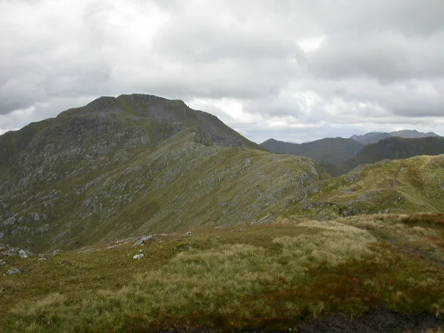
Sgùrr a' Mhaoraich
Also known as: Sgùrr a' Mhorair
Sgùrr a' Mhaoraich — Named summit at 1027 m.

Wikimedia Commons contributors — see linked file page for photographer and licence licence
Plan your visit
- Typical visit
- 3 h–8 h
- Best time of year
- Late spring – early autumn (May–Oct)
- Free entry
- Dog-friendly
About
Sgùrr a' Mhaoraich is a named summit in the United Kingdom. Also known as: Sgùrr a' Mhorair. Wikidata describes it as: "Named summit at 1027 m.". Coordinates: 57.1056°, -5.3304°.
Photo gallery
From the Wikipedia article
Sgùrr a' Mhaoraich is a Scottish mountain located to the north of Loch Cuaich in the northwestern highlands. It has a height of 1027 m (3369 ft) and is classed as a Munro. Viewed from Kinloch Hourn to the west, or from the north, it shows large, steep, rocky flanks with a complex series of ridges and corries, but like its neighbours such as Gleouraich, its southern side is gentler and grassier. The mountain is known in Gaelic, and used to be known in English as Sgùrr a' Mhorair, meaning "peak of the nobleman", but has been changed on modern maps to Sgùrr a' Mhaoraich, which derives from the Gaelic maorach meaning shellfish. This may be a reference to the hill's ribbed summit, which has been said to resemble a shell. In the Gaelic periodical Gairm in 1979, an article noted that though the writer had seen the name "Sgùrr a' Mhaoraich" in writing, he had only ever heard "Sgùrr a' Mhorair" spoken and jokes that Gheibhear maoraich air cladach, ach cha do thachair orm riamh buidheann diubh a’ siurradh nam beann - "You find shellfish on the beach, but I've never come across a bunch wandering on the mountains". The mountain is most commonly climbed from the shores of Loch Cuaich to the south. A stalker's path leads up the Bac nan Canaichean ridge to the subsidiary top of Sgùrr Coire nan Eiricheallach (891 m or 2,923 ft), which is connected to the main summit by a 1.5 km ridge, which has a number of rocky outcrops which can be scrambled over or bypassed. An alternative, and less frequently climbed route is from the northeast end of Gleann Cuaich (Glen Quoich), by way of a stalker's path which runs the length of Coire a' Chaorainn and to the rocky summit of Am Bathaich (892 m or 2,927 ft), and from there south to Sgùrr a' Mhaoraich via a high bealach.
Excerpt from Wikipedia under CC BY-SA 4.0. See the source article linked in Sources below.
- Coordinates
- 57.1056, -5.3304
- Address
- Highland, Scotland
- Official site
- www.walkhighlands.co.uk
Sources
- osm: n260172914 (ODbL)
- wikipedia: Sgùrr a' Mhaoraich (CC BY-SA 4.0)
- commons: Sgurr a’ Mhaoraich.jpg (CC BY-SA 4.0)
Other places nearby
Loading nearby places…
Nearby
 📷 3
📷 3Natural landmarks · Scottish Highlands
Sgùrr a' Mhaoraich
Sgùrr a' Mhaoraich — 1027m high mountain in Highland, Scotland, UK.
 📷 3
📷 3Mountains & hills · Scottish Highlands
Sgurr a' Mhaoraich - Sgurr a' Mhaoraich Beag
Sgurr a' Mhaoraich - Sgurr a' Mhaoraich Beag — a mountain in scotland-highlands, United Kingdom.

Mountains & hills · Scottish Highlands
Sgurr a' Mhaoraich - Am Bathaich
Sgurr a' Mhaoraich - Am Bathaich — a mountain in scotland-highlands, United Kingdom.
 📷 3
📷 3Mountains & hills · Scottish Highlands
Sgurr a' Mhaoraich - Sgurr Coire nan Eiricheallach
Sgurr a' Mhaoraich - Sgurr Coire nan Eiricheallach — a mountain in scotland-highlands, United Kingdom.
 📷 3
📷 3Natural landmarks · Scottish Highlands
Eas Coire nan Choire
Eas Coire nan Choire in Scotland Islands, United Kingdom.
 📷 3
📷 3Mountains & hills · Scottish Highlands
Sgùrr Thionail
Sgùrr Thionail — a mountain in scotland-highlands, United Kingdom.
More mountains in this region
 📷 3
📷 3Mountains & hills · Scottish Highlands
A' Bhuidheanach Bheag
A' Bhuidheanach Bheag — Named summit at 936 m.
 📷 3
📷 3Mountains & hills · Scottish Highlands
A' Chailleach
A' Chailleach — Named summit at 997 m.
 📷 3
📷 3Mountains & hills · Scottish Highlands
A' Chailleach
A' Chailleach — Named summit at 930 m.
 📷 3
📷 3Mountains & hills · Scottish Highlands
A' Chaoirnich
A' Chaoirnich — Named summit at 875 m.
Frequently asked questions
- Where is Sgùrr a' Mhaoraich?
- Sgùrr a' Mhaoraich is in Scottish Highlands, in the United Kingdom — coordinates 57.1056°, -5.3304°.
- Is Sgùrr a' Mhaoraich free to visit?
- Yes — admission to Sgùrr a' Mhaoraich is free.