Natural landmarks · North West England
Semerwater
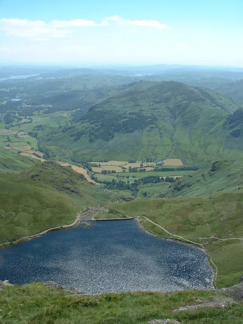
Semerwater — lake in North Yorkshire, England, UK.

Wikimedia Commons contributors — see linked file page for photographer and licence licence
Plan your visit
- Typical visit
- 1 h–2 h
- Free entry
- Dog-friendly
About
Semerwater is a named natural landmark in the United Kingdom. Wikidata describes it as: "lake in North Yorkshire, England, UK". Coordinates: 54.2806°, -2.1250°.
Photo gallery
Protected designations
- Site of Special Scientific Interest: Semerwater SSSI
Designations sourced from Natural England open data under OGL v3.
From the Wikipedia article
Semerwater () is the second largest natural lake in North Yorkshire, England, after Malham Tarn. It is half a mile (800 m) long, covers 100 acres (0.40 km2) and lies in Raydale, opposite the River Bain within Yorkshire Dales National Park. A private pay and display parking area is at the foot of the lake. Semerwater attracts canoers, windsurfers, yachtsmen and fishermen. There are three small settlements nearby: Stalling Busk Countersett Marsett Semerwater was the subject of a number of sketches and paintings by the artist J. M. W. Turner. Semerwater is a pleonastic place name. The name, first recorded in 1153, derives from the Old English elements sæ 'lake', mere 'lake' and water. The form "Lake Semerwater" introduces a fourth element with the same meaning. The lake is a Site of Special Scientific Interest, first notified in 1975.
Excerpt from Wikipedia under CC BY-SA 4.0. See the source article linked in Sources below.
- Coordinates
- 54.2806, -2.1250
- District
- North Yorkshire
- Parish
- Bainbridge
- Postcode
- DL8 3DD
- Parliamentary constituency
- Richmond and Northallerton
Sources
- wikidata: Q7337694 (CC0)
- wikipedia: Semerwater (CC BY-SA 4.0)
- commons: Semerwater2.jpg (CC BY-SA 4.0)
Other places nearby
Loading nearby places…
Nearby
 📷 3
📷 3Historic bridges · North West England
Little Ings Bridge
Little Ings Bridge — Grade II listed building-listed bridge in england-north-west, United Kingdom.
 📷 3
📷 3Historic bridges · North West England
Semer Water Bridge
Semer Water Bridge — Grade II listed building-listed bridge in england-north-west, United Kingdom.
 📷 3
📷 3Historic houses · North West England
Countersett Hall
Countersett Hall — house in Bainbridge, Richmondshire, England, UK.
Campsites · North West England
Stablefell Camping
Stablefell Camping — a campsite in england north west.
 📷 3
📷 3Hill forts · North West England
Bainbridge Hillfort (Late Bronze Age, Early Iron Age)
Bainbridge Hillfort (Late Bronze Age, Early Iron Age) — a hill fort in england-north-west, United Kingdom.
Vineyards · North West England
Bainbridge slight univallate hillfort
Bainbridge slight univallate hillfort — a UK vineyard in england north west, producing English or Welsh wine from cool-climate grape varieties.
More natural landmarks in this region
 ★ Iconic📷 4
Natural landmarks · North West England
Coniston Water
Lake District lake — Swallows and Amazons setting and Donald Campbell water-speed history.
 📷 3
📷 3Natural landmarks · North West England
Elter Water
Elter Water — lake in the United Kingdom.
 📷 3
📷 3Natural landmarks · North West England
Esthwaite Water
Esthwaite Water — lake in the United Kingdom.
 Flagship📷 3
Natural landmarks · North West England
Stickle Tarn
Stickle Tarn — lake near Harrison Stickle, Langdale, Cumbria, United Kingdom.
Frequently asked questions
- Where is Semerwater?
- Semerwater is in North-West England, United Kingdom (postcode DL8 3DD), in the parish of Bainbridge.
- Is Semerwater a protected site?
- Yes — Semerwater is part of the Semerwater SSSI Site of Special Scientific Interest.
- Is Semerwater free to visit?
- Yes, Semerwater is free to enter.
- How do I get to Semerwater?
- Drivers can navigate to postcode DL8 3DD. It sits within the Richmond and Northallerton parliamentary constituency.