Mountains & hills · Scottish Highlands
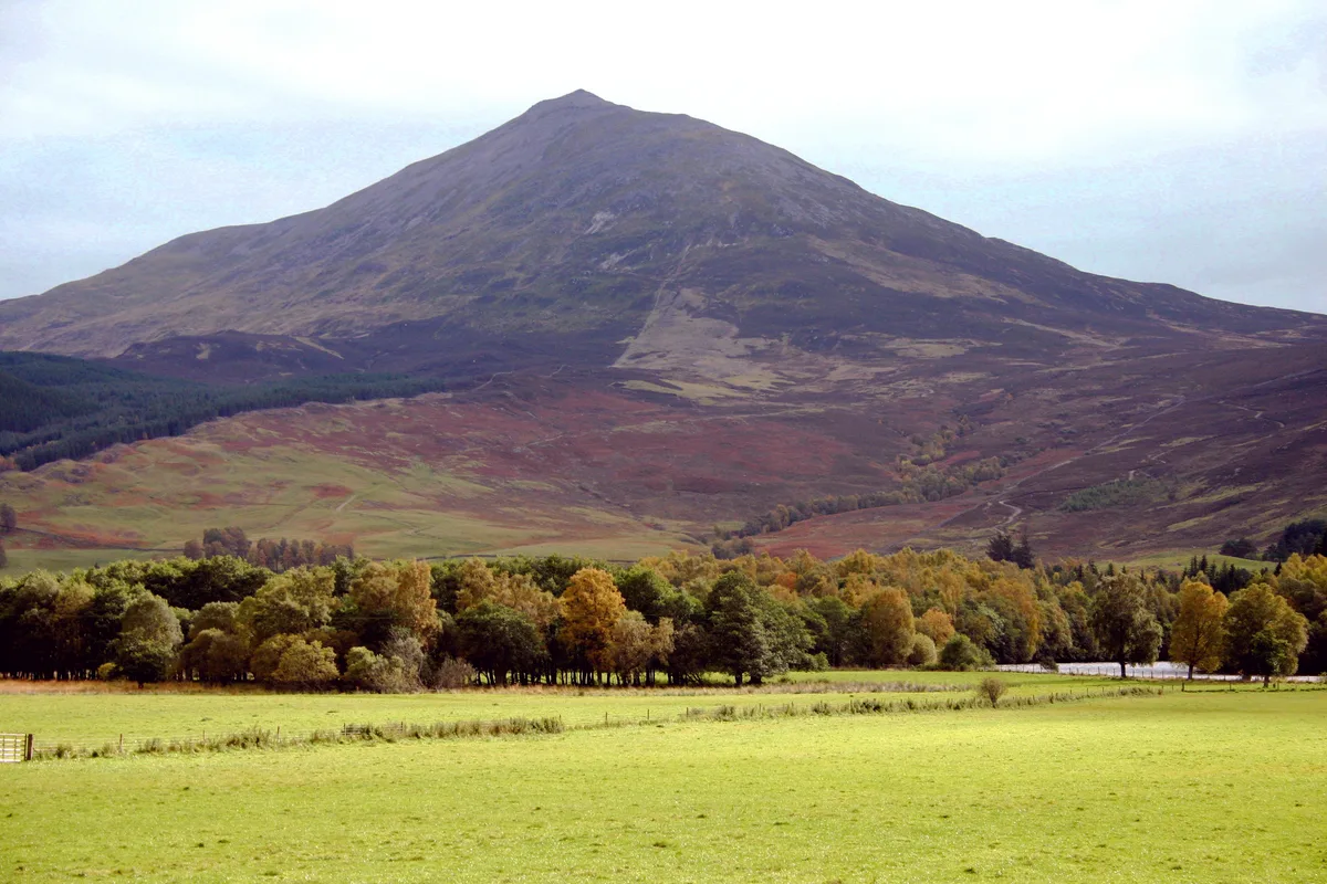
Schiehallion
Also known as: Sìth Chailleann, Sìdh Chailleann
Schiehallion — Named summit at 1083 m.

Wikimedia Commons contributors — see linked file page for photographer and licence licence
Plan your visit
- Typical visit
- 3 h–8 h
- Best time of year
- Late spring – early autumn (May–Oct)
- Free entry
- Dog-friendly
About
Schiehallion is a named summit in the United Kingdom. Also known as: Sìth Chailleann. Wikidata describes it as: "Named summit at 1083 m.". Coordinates: 56.6669°, -4.1003°.
Photo gallery
From the Wikipedia article
Schiehallion (; Scottish Gaelic: Sìth Chailleann, IPA: [ʃiˈxaʎən̪ˠ]) is a prominent cone-shaped mountain in the Breadalbane region of the Scottish Highlands, in the county of Perthshire. It rises to 1,083 metres (3,553 ft) and is classed as a Munro. Schiehallion has a rich flora, interesting folklore and archaeology, and a unique place in scientific history for an 18th-century experiment in "weighing the Earth". It is near the centre of mainland Scotland. The mountain's popularity amongst walkers led to erosion on its footpath and extensive repairs were undertaken in 2001.
Excerpt from Wikipedia under CC BY-SA 4.0. See the source article linked in Sources below.
Background
History
The slopes of Schiehallion have been inhabited and cultivated since the first millennium BC until approximately two hundred years ago. Schiehallion has been used for grazing sheep and stalking red deer. Since 1999 the eastern side of the mountain has been owned by the John Muir Trust.
Description
Schiehallion's isolated position and regular shape led it to be selected by the English astronomer Charles Mason (of Mason–Dixon line fame) for a ground-breaking experiment to estimate the mass of the Earth in 1774. The deflection of a pendulum by the mass of the mountain provided an estimate of the mean density of the Earth, from which its mass and a value for Newton's gravitational constant G could be deduced. Mason turned down a commission to carry out the work, and it was instead coordinated by the Astronomer Royal, Nevil Maskelyne. He was assisted in the task by mathematician Charles Hutton, who devised a graphical system to represent large volumes of surveyed heights, later known as…
Sourced from Wikipedia under CC BY-SA 4.0.
- Coordinates
- 56.6669, -4.1003
- Address
- Perthshire, Scotland
- Official site
- www.hill-bagging.co.uk
Sources
- osm: n273925520 (ODbL)
- wikipedia: Schiehallion (CC BY-SA 4.0)
- commons: Schiehallion 01.jpg (CC BY-SA 4.0)
Other places nearby
Loading nearby places…
Nearby
 📷 4
📷 4Natural landmarks · Scottish Highlands
Schiehallion
Schiehallion — mountain in Perth and Kinross, Scotland, UK.
 📷 3
📷 3Natural landmarks · Scottish Highlands
Craigh Na Dun (Outlander serie)
Craigh Na Dun (Outlander serie) — a other in scotland-highlands, United Kingdom.
 Flagship📷 3
Natural landmarks · Scottish Highlands
Dunalastair Water
Dunalastair Water — lake in Perth and Kinross, Scotland, UK, on the River Tummel.
 📷 3
📷 3Memorials & monuments · Scottish Highlands
Nevil Maskelyne Memorial
Nevil Maskelyne Memorial — a memorial in scotland-highlands, United Kingdom.
 📷 3
📷 3Archaeological sites · Scottish Highlands
Braes of Foss, dun site
Braes of Foss, dun site — a archaeological in scotland-highlands, United Kingdom.
 📷 4
📷 4Historic bridges · Scottish Highlands
Dunalastair House
Dunalastair House in Scotland Islands, United Kingdom.
More mountains in this region
 📷 3
📷 3Mountains & hills · Scottish Highlands
A' Bhuidheanach Bheag
A' Bhuidheanach Bheag — Named summit at 936 m.
 📷 3
📷 3Mountains & hills · Scottish Highlands
A' Chailleach
A' Chailleach — Named summit at 997 m.
 📷 3
📷 3Mountains & hills · Scottish Highlands
A' Chailleach
A' Chailleach — Named summit at 930 m.
 📷 3
📷 3Mountains & hills · Scottish Highlands
A' Chaoirnich
A' Chaoirnich — Named summit at 875 m.
Frequently asked questions
- Where is Schiehallion?
- Schiehallion is in Scottish Highlands, in the United Kingdom — coordinates 56.6669°, -4.1003°.
- Is Schiehallion free to visit?
- Yes — admission to Schiehallion is free.